Related Research Articles
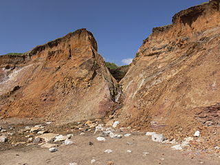
A chine is a steep-sided coastal gorge where a river flows to the sea through, typically, soft eroding cliffs of sandstone or clays. The word is still in use in central Southern England—notably in East Devon, Dorset, Hampshire and the Isle of Wight—to describe such topographical features. The term 'bunny' is sometimes used to describe a chine in Hampshire. The term chine is also used in some Vancouver suburbs in Canada to describe similar features.

Alum Bay is a bay near the westernmost point of the Isle of Wight, England, within close sight of the Needles rock formation. Of geological interest and a tourist attraction, the bay is noted for its multi-coloured sand cliffs. The waters and adjoining seabed form part of the Needles Marine Conservation Zone and the shore and heath above are part of the Headon Warren and West High Down Site of Special Scientific Interest.

Sandown is a seaside resort and civil parish on the south-east coast of the Isle of Wight, United Kingdom with the resort of Shanklin to the south and the settlement of Lake in between. Together with Shanklin, Sandown forms a built-up area of 21,374 inhabitants.

Sandown Bay is a broad open bay which stretches for much of the length of the Isle of Wight's southeastern coast. It extends 8+1⁄2 miles (13.7 km) from Culver Down, near Yaverland in the northeast of the Island, to just south of Shanklin, near the village of Luccombe in the southwest. At Luccombe, the bay is separated from The Undercliff by a large headland from which Upper Ventnor sits atop. The towns of Shanklin, Lake and Sandown are on the bay's coast, while Luccombe and Upper Ventnor feature panoramic views across both Sandown Bay to the East and the Undercliff to the southwest. Due to the bay being relatively sheltered from offshore winds it is often used as temporary anchorage point for boats, including large cargo ships, before continuing east towards Continental Europe, or north towards The Solent.

Brook is a village on the Isle of Wight, England. According to the Post Office the 2011 census population was included in the civil parish of Brighstone.

Lake is a large village and civil parish located on Sandown Bay, on the Isle of Wight, England. It is six miles south-east of Newport situated between Sandown and Shanklin, and 1+1⁄2 miles (2.4 km) to the east of the hamlet of Apse Heath.

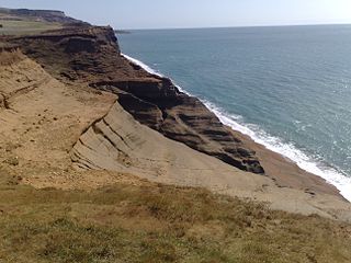
Compton Bay is a bay located on the southwest section of the Isle of Wight, England. Its northwestern edge is defined by the distinctive white chalk cliff of Freshwater Cliff, named after adjacent Freshwater Bay, which forms a small cove with the village of Freshwater situated just behind. Its northeastern edge is formed from the soft red and orange lower cretaceous rocks of Brook Bay, which are rapidly eroding.

Monks Bay is situated on the southern coast of the Isle of Wight, England just to the east of the village of Bonchurch, it is around 1⁄3 mile (0.54 km) in length. It is popular with visitors and is one of the natural highlights of the town, which has hosted such figures as Charles Dickens. The bay is also a good site for local flora, and it has a row of houses which look out to the English Channel.

The Isle of Wight Coastal Path is a circular long-distance footpath of 70 miles (113 km) around the Isle of Wight, UK. It follows public footpaths and minor lanes, with some sections along roads.
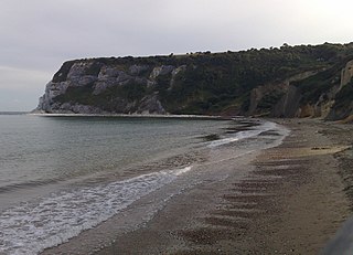
Whitecliff Bay is a sandy bay near Foreland which is the easternmost point of the Isle of Wight, England, about two miles south-west of Bembridge and just to the north of Culver Down. The bay has a shoreline of around three-quarters of a mile (1.2 km) and has a popular sandy shingle beach which is over half a mile long. It is a tourist site with three holiday parks in the vicinity of the bay; it has two cafes though minimal facilities. Access is limited and only possible down two steeply sloping concrete tracks.
Ladder Chine is a geological feature on the south west coast of the Isle of Wight, England. It is west of the village of Chale. It is a sandy coastal ravine, one of a number of such chines on the island created by stream erosion of soft Cretaceous rocks. It leads from the 190 foot high clifftop to a knickpoint approximately halfway down the cliff face above Chale Bay beach.

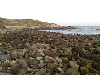
Churchill Chine is a geological feature on the south west coast of the Isle of Wight, England. It is west of the village of Brook and just east of Hanover Point. It is a small sandy coastal gully, one of a number of such chines on the island created by stream erosion of soft Cretaceous rocks. It leads from the 30 foot high clifftop to the beach of Brook Bay.

Chale Bay is a bay on the south-west coast of the Isle of Wight, England. It lies to the west of the village of Chale from which it takes its name. It faces south-west towards the English Channel, its shoreline is 3+1⁄4 miles (5.2 km) in length and is gently curving. It stretches from Artherfield Point in the north-west to Rocken End in the south-east.

Horseshoe Bay is a small bay on the south-east coast of the Isle of Wight, England. It lies at the east end of the headland of Culver Down. It faces south-east towards the English Channel and its shoreline is approximately 100 yards (90 m) in length. It should not be confused with a similarly named Horseshoe Bay about 8 miles (13 km) southwest at Bonchurch.
Seagrove Bay is a bay on the northeast coast of the Isle of Wight, England. It lies to the east of the village of Seaview facing towards Selsey Bill with a 2⁄3 mile (1.1 km) shoreline stretching from Nettlestone Point in the north to Horestone Point in the south. The bay has both the Seaside Award Flag and the Water Quality Award.

Wheelers Bay is a small bay on the south-east coast of the Isle of Wight, England. It lies to the east of Ventnor. It faces south-east towards the English Channel, its shoreline is 300 yards (270 m) in length. A 90-yard (82 m) section of the bay, to the side of the slipway, is used as dry-storage for boats; in recent years this has been targeted by thieves. The bay is home to an open-air café known as The Seapot.

Orchard Bay is a small bay with sand and shingle beach on the south-east coast of the Isle of Wight, England. It lies to the south-west of the Ventnor Botanic Garden and just along the coast west from Steephill Cove. It faces south towards the English Channel, its shoreline is 220 yards (200 m) in length - 65 yards (60 m) of which is beach.
Watershoot Bay is a bay on the southernmost tip of the Isle of Wight, England. It lies 1+1⁄2 miles (2.4 km) to the south-west of the village of Niton. It faces south out into the English Channel, and is one of the smallest and remotest bays of the Isle of Wight with a rocky shoreline only around 500 feet (150 m) in length. It lies to the west of St. Catherine's Point lighthouse and is surrounded by a 170-acre area of undulating grassland and scrub owned by the National Trust and known as Knowles Farm.

Gurnard Bay is a bay on the north-west coast of the Isle of Wight, England, in the western arm of the Solent. It lies to the north-west of the village of Gurnard from which it takes its name. Its shoreline is 1+1⁄4 miles (2.0 km) in length and is gently curving. It stretches from Gurnard Head in the west to Egypt Point to the east. A panoramic view of the bay and the village of Gurnard can be seen from ferries approaching Cowes or East Cowes from the Solent. There is a pebble and shingle beach on the bay which is bordered by a row of municipally-owned beach huts. Watersports are popular pastimes in the bay, and the Gurnard Sailing Club is located at its eastern end.
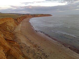
Brook Bay is a bay on the south western coast of the Isle of Wight, England. It lies to the west of the village of Brook. It faces south west out into the English Channel. It stretches about 2km from Hanover Point in the east to Sudmoor Point to the west. Much of the surrounding land, including the hamlet of Brookgreen is owned by the National Trust.
References
- ↑ "Google Earth". earth.google.com. Retrieved 2020-10-05.