This article may be confusing or unclear to readers.(August 2011) |

County Kerry, Ireland is home to a wide range of fortified castle structures. The castles below are referenced by the Irish National Grid on Ordnance Survey maps.
This article may be confusing or unclear to readers.(August 2011) |
County Kerry, Ireland is home to a wide range of fortified castle structures. The castles below are referenced by the Irish National Grid on Ordnance Survey maps.
Castles and maps listed below are sourced mainly from the Discovery (Irish TV) series. The series attributed the maps below (Scale: 1:50 000) to Ordnance Survey, the Irish national mapping agency. Most of the listed castles and forts clearly indicated on the maps and are accessible to walkers and the general public. Some maps use the older SCALE 1:126,720 from the series published in 1986.
Listed as "Castle" or "Promontory Fort", markings of "Dun Cinn Tire" and "Signal Tower" are also included.
Refers to the Ordnance Survey sheet on which the structure can be found.
National Grid segment in which the structure is located. Each grid segment covers an actual area of 1 square kilometre.
The number of the Vertical, N-S, line of the National Grid system.
The number of the Horizontal, E-W, line of the National Grid system. The structure to be located will then lie in the square to the North East of the intersecting H/V lines.
Some general reference point clearly marked on the map or generally, well known; a town, village, harbour, headland or road etc.
Nearest main road or road, e.g. N 22 or R 559. If structure is easily accessible? Visibility of site from road.
As some castles are obliterated, the location of the sites are listed, as in the case of Tralee Castle. Because their position and prominence was historically important, the known information is entered so that a more comprehensive understanding of the area and era may be obtained.
| Structure | OS Sheet | N.G. Segment | Vert. | Horiz. | Type | Near | Comment | Marked Y/N |
|---|---|---|---|---|---|---|---|---|
| Dunquin | 70 | V | 31 | 99 | - | Dunquin | - | Y |
| Shrone Point | 83 | - | 35 | 76 | Prom Fort | Portmagee | Valentia Island | - |
| Raheen (near) | 70 | V | 35 | 97 | Prom Fort | Slea Head | R 559 | - |
| Foilnanean Cliffs | 83 | - | 36 | 76 | Prom Fort | Portmagee | Valentia Island | - |
| Ventry Harbour | - | - | 37 | 97 | - | - | - | - |
| Cahertrant | 70 | V | 37 | 97 | Prom Fort | Leckeel | off R 559 | - |
| Gallarus Castle | 70 | Q | 38 | 5 | - | Murreaght | R 559 | - |
| Alachai Mor | 83 | - | 38 | 65 | Prom Fort | St. Finan's Bay | - | - |
| Cloghanecanuig | 83 | 38 | 68 | - | - | - | - | - |
| Ballymore Point | - | - | 39 | 99 | Prom Fort | Ventry Harbour | R 559 | - |
| Feonanagh | 70 | - | 40 | 9 | - | - | - | - |
| Ballinskelligs Castle | - | - | 43 | 65 | - | Ballinskelligs | - | - |
| Cooncrome | 83 | - | 43 | 81 | Prom Fort | Caherciveen | - | - |
| Ballymacadoyle Hill | 70 | V | 43 | 98 | Prom Fort | Dingle | Beyond Colaiste Ide | Y |
| Ballycarbery Castle | 83 | - | 44 | 79 | - | Caherciveen | off N 70 | - |
| Emiaghmore | 83 | - | 45 | 70 | - | Ballinskelligs | R 566 | - |
| Beenbane Cliffs | 70 | V | 45 | 98 | Prom Fort | Dingle | E. harbour entrance | Y |
| Doonsheane | 70 | V | 47 | 98 | Prom Fort | Dingle | Short Strand Inlet | |
| Bulls Head | 70 | V | 49 | 97 | Prom Fort | Lispole | off N 86 | - |
| Minard | 70 | 53 | 97 | Minard Head | Anascaul/Dingle | Y | ||
| Caherdaniel | 83 | - | 54 | 58 | off N 70 | Example | ||
| Cill Muire | 83 | Example | 54 | 58 | Example | Minard East | Example | Example |
| Castle Cove | 83 | Example | 59 | 60 | Example | Castle Cove | N 70 | Example |
| Straigue Fort | 83 | Example | 61 | 63 | Stone Fort | Caherdaniel | Example | Example |
| Kilshannig | 71 | Q | 62 | 19 | Signal Tower | Castlegregory | Example | Example |
| Knockglass More | 71 | Example | 70 | 10 | Prom Fort | Camp | Example | Example |
| Fenit Island | 71 | Q | 72 | 17 | Example | Fenit R 558 | Example | Yes |
| Barrow | 71 | Q | 72 | 18 | Example | Golf Club | Example | Example |
| Caherconree | 71 | Q | 72 | 96 | Hill Fort | Camp R 560 | Example | Yes |
| Ballyheige Fortification | 71 | Q | 73 | 28 | Example | Ballyheige | Example | Example |
| Rahoneen | 71 | Q | 75 | 20 | Example | Ardfert | Example | Example |
| Rathmoral | 71 | Q | 79 | 29 | Example | Ballyheige | Example | Example |
| Ballymaquim | 71 | Example | 82 | 26 | Example | Abbeydorney | Example | Example |
| Tralee castle | 71 | Example | 83 | 14 | Example | Town center | No trace | No |
| Dromaloughane | 78 | Example | 85 | 91 | Example | Beaufort | Example | Example |
| Ballybeggan | 71 | Example | 86 | 15 | Example | Tralee Racecourse | N 69 | Example |
| Dromreag | 71 | Example | 88 | 4 | Example | Fieries | Example | Example |
| Lixnaw Tower | 71 | Example | 88 | 29 | Example | Lixnaw | R 557 | Example |
| Kenmare Castle | 78 | V | 88 | 70 | Example | Tubrid | off N 70 | Example |
| Dromore Castle | 78 | Example | 88 | 91 | Example | Beaufort | off N 72 | Example |
| Doonimlaghbeg | 71 | Example | 89 | 11 | Example | Example | N 22 | Example |
| Lixnaw Bridge | 71 | Example | 89 | 29 | Example | Lixnaw | R 557 | Example |
| Fieries | Example | Example | 90 | 2 | Example | Example | R 561 | Example |
| Roxborough | 71 | Example | 91 | 4 | Example | Farranfore | N 22 | Example |
| Aghadoe Castle (Parkavonear Castle) | 78 | Example | 93 | 92 | Example | Example | R 562/ N 22 | Example |
| Ross Castle | 78 | Example | 94 | 88 | Example | Killarney | Example | Example |
| Castlelough | 78 | Example | 97 | 88 | Example | Killarney | N 71 | Example |
| Ardea Castle | Example | Example | Example | Example | Example | Example | Example | Example |
| Ballybunion Castle | Example | Example | Example | Example | Example | Example | Example | Example |
| Ballingarry Castle | Example | Example | Example | Example | Example | Example | Example | Example |
| Ballymalis Castle | ||||||||
| Ballyseedy Castle | Sheet | Sgmt | V | H | Tralee | Hotel |
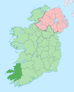
County Kerry is a county in Ireland. It is located in the South-West Region and forms part of the province of Munster. It is named after the Ciarraige who lived in part of the present county. The population of the county was 147,707 at the 2016 census.

Tralee is the county town of County Kerry in the south-west of Ireland. The town is on the northern side of the neck of the Dingle Peninsula, and is the largest town in County Kerry. The town's population was 23,691 as of the 2016 census, thus making it the 8th largest town, and 14th largest urban settlement, in Ireland. Tralee is well known for the Rose of Tralee International Festival, which has been held annually in August since 1959.
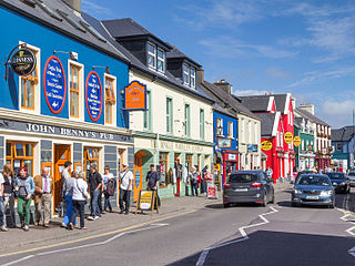
Dingle is a town in County Kerry, Ireland. The only town on the Dingle Peninsula, it sits on the Atlantic coast, about 50 kilometres (30 mi) southwest of Tralee and 71 kilometres (40 mi) northwest of Killarney.

The N22 road is a national primary road in Ireland which goes through counties Kerry and Cork, from Tralee in the west through Killarney, Macroom and Ballincollig to Cork City in the east.

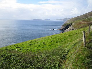
The Dingle Peninsula is the northernmost of the major peninsulas in County Kerry. It ends beyond the town of Dingle at Dunmore Head, the westernmost point of Ireland and arguably Europe.

Kinvara or Kinvarra is a sea port village located in the southwest of County Galway, Ireland. It is located in the civil parish of Kinvarradoorus in the north of the barony of Kiltartan. Kinvarra is also a District Electoral Division (DED).

Ballyferriter is a Gaeltacht village in County Kerry, Ireland. It is in the west of the Corca Dhuibhne (Dingle) peninsula and according to the 2002 census, about 75% of the town's population speak the Irish language on a daily basis. The village is named after the Norman-Irish Feiritéar family who settled in Ard na Caithne in the late medieval period. The last Chief of the Name was the seventeenth-century Bard and leader Piaras Feiritéar who was executed. The older Irish name for the village An B[h]uailtín is still used locally.

Ventry, officially Ceann Trá, is a Gaeltacht village in County Kerry, Ireland, on the Dingle Peninsula, 7 kilometres west of Dingle. Due to its long sandy beach, Ventry is a popular tourist destination. The town is connected to Dingle via the R559 regional road.

The Kerry Senior Football Championship is an annual Gaelic football competition organised by the Kerry County Board of the Gaelic Athletic Association since 1889 for the top Gaelic football teams in the county of Kerry in Ireland.

Tralee Bay is located in on the west coast of County Kerry, Ireland. It is situated between Kerry Head on the north side and the Maharees on the west and extends eastwards as far as the bridge at Blennerville. Several small rivers feed into the bay through the town of Tralee. Villages around the bay include; Ballyheigue, Fenit, Kilfinora, Spa, Blennerville, Camp and Castlegregory.

Dunkerron Castle is a ruined four-storey tower house located in Templenoe, near Kenmare, County Kerry, in south-west Ireland. The castle was the family seat of the O'Sullivan Mór family from the late 16th century.
Slieve Mish Mountains, is a predominantly sandstone mountain range at the eastern end of the Dingle Peninsula in County Kerry, Ireland. Stretching 19 kilometres, from the first major peak of Barnanageehy outside of Tralee in the east, to Cnoc na Stuaice in near Central Dingle in the west, the range has over 17 material peaks, with the core of the mountain range based around the massif of its highest peak, Baurtregaum, and its deep glacial valleys of Derrymore Glen and Curraheen Glen.
Two Rock is a mountain in Dún Laoghaire–Rathdown, Ireland. It is 536 metres high and is the 382nd highest mountain in Ireland. It is the highest point of the group of hills in the Dublin Mountains which comprises Two Rock, Three Rock, Kilmashogue and Tibradden Mountains. The mountain takes its name from the two granite tors that lie to the south-east of the summit. From the summit, which is called Fairy Castle, there are views of much of the Dublin area from Tallaght to Howth to the north while Bray Head, Killiney Hill, the Great Sugar Loaf and the Wicklow Mountains are visible to the south. The summit area is mostly shallow bog while ferns and gorse cover the lower slopes. The mountain is also an important habitat for red grouse.

The Mallow–Tralee line runs from Mallow to Killarney and Tralee Casement. Intermediate stations are Banteer, Millstreet, Rathmore, and Farranfore.
The High Sheriff of Kerry was the British Crown's judicial representative in County Kerry, Ireland from the 16th century until 1922, when the office was abolished in the new Free State and replaced by the office of Kerry County Sheriff. The sheriff had judicial, electoral, ceremonial and administrative functions and executed High Court Writs. In 1908, an Order in Council made the Lord-Lieutenant the Sovereign's prime representative in a county and reduced the High Sheriff's precedence. However the sheriff retained his responsibilities for the preservation of law and order in the county. The usual procedure for appointing the sheriff from 1660 onwards was that three persons were nominated at the beginning of each year from the county and the Lord Lieutenant then appointed his choice as High Sheriff for the remainder of the year. Often the other nominees were appointed as under-sheriffs. Sometimes a sheriff did not fulfil his entire term through death or other event and another sheriff was then appointed for the remainder of the year. The dates given hereunder are the dates of appointment. All addresses are in County Kerry unless stated otherwise.

Doonshean or Doonsheane is a townland in western County Kerry in Ireland. It is located about 3.8 km east from the neighbouring town of Dingle.
Fahan is an area on the Dingle Peninsula in County Kerry, Ireland, noted for a collection of clochán, or drystone beehive huts. Fahan lies below Mount Eagle on the southern coast of the Dingle peninsula, to the west of the fishing village of Ventry and to the east of the steep cliffs of Slea Head. Fahan has many antiquities, including cave dwellings, stone beehive huts, stone monuments and forts.

Cloonnafinneela is a townland of County Kerry, Ireland.