List of covered bridges in Columbia County, Pennsylvania

Last updated

The green dots are the approximate locations of the covered bridges Covered bridges in Columbia County, Pennsylvania.png
The green dots are the approximate locations of the covered bridges

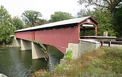
As of 2007, there are a total of 21 covered bridges in Columbia County, Pennsylvania, in the United States. The number of covered bridges in Columbia County is the third highest number of covered bridges in any one county in Pennsylvania, behind Washington County and Lancaster County. [1] [2] Columbia County is also home to one of two sets of twin covered bridges in the United States. [1]

Contents

By 1962, a large number of the covered bridges in Columbia County were experiencing weathering. During this year, Columbia County began working on the preservation of the damaged bridges. [3]

There is an organization known as the Columbia County Covered Bridges Association that has existed since 1991 and supports the presence of covered bridges in the county. The county commissioner of Columbia County, Chris Young, is also a supporter of Columbia County's covered bridges, stating that "When you stand on a covered bridge, you're actually going back in time". [2] 18 of the covered bridges are open to vehicle traffic, as of 2002, and these are maintained by officials of Columbia County. The remainder of the bridges are maintained by the Columbia County Covered Bridges Association. A number of the covered bridges are attractions for local and regional tourism. They are also used for picnics and fishing. [2]

A number of the covered bridges were damaged during Tropical Storm Lee in 2011. Three of these bridges were the Josiah Hess Covered Bridge No. 122, the Davis Covered Bridge, and the Rupert Covered Bridge No. 56. The Josiah Hess Covered Bridge No. 122 received some damage to its abutments. The Davis Covered Bridge was closed after the tropical storm. The Rupert Covered Bridge No. 56 sustained minor damage from a tree branch that went through its side. [4]

Statistics and history

The existing covered bridges in Columbia County are spread across at least 11 townships. Out of these, four are in Fishing Creek Township, five are in Cleveland Township, two are in Greenwood Township, two are in Jackson Township, and two are in Franklin Township. The rest of the townships in Columbia County have one or zero covered bridges. [5]

While fewer than 20 covered bridges remain in Columbia County in the 21st century, a total of 116 covered bridges have been built in the county, meaning that 97 covered bridges in the county have been destroyed. Of these, nine were destroyed in the 1800s, including one, the Berwick-Nescopeck Covered Bridge, that was destroyed in the late 1830s. Considerably more covered bridges were destroyed in the 1900s. In this century, a total of 60 covered bridges were lost. Two more covered bridges were destroyed in the 21st century. Additionally, 17 covered bridges were lost at an unknown date. [5]

Table

NameDate builtLengthTypeStream crossedImageSource
Creasyville Covered Bridge 188144.5 feet (13.6 m) Queen post truss Little Fishing Creek Creasyville Covered Bridge 9.jpg [1]
Davis Covered Bridge 187587 feet (27 m) Burr Arch Roaring Creek Davis Covered Bridge 2.JPG [1]
Esther Furnace Covered Bridge 1881101 feet (31 m) Queen post Roaring Creek [1]
Fowlersville Covered Bridge 188640 feet (12 m) Queen post West Branch Briar Creek (later moved) FOWLERSVILLE COVERED BRIDGE, COLUMBIA CO. PENNSYLVANIA.jpg [1]
Hollingshead Covered Bridge No. 40 1851116 feet (35 m) Burr Arch Catawissa Creek Hollingshead Covered Bridge 1.JPG [1]
Johnson Covered Bridge No. 28 188261 feet (19 m) Queen truss Mugser Run Johnson Covered Bridge 1.JPG [1]
Josiah Hess Covered Bridge No. 122 1875110 feet (34 m) Burr arch truss Huntington Creek Josiah Hess Covered Bridge 14.JPG [1]
Jud Christie Covered Bridge No. 95 187663 feet (19 m) Queen post truss Little Fishing Creek Jud Christian Covered Bridge 1.JPG [1]
Lawrence L. Knoebel Covered Bridge 188141 feet (12 m) Queen truss West Creek (later moved) Lawrence L. Knoebel Covered Bridge 1.JPG [1]
Kramer Covered Bridge No. 113 188150 feet (15 m) Queen post Mud Run Kramer Covered Bridge 8.JPG [1]
Kreigbaum Covered Bridge 187662 feet (19 m) Queen post South Branch Roaring Creek Kreigbaum Covered Bridge 1.JPG [1]
Parr's Mill Covered Bridge No. 10 186684 feet (26 m) Burr Arch Roaring Creek Parr's Mill Covered Bridge 4.JPG [1]
Patterson Covered Bridge No. 112 187582 feet (25 m) Burr truss Green Creek Patterson CB 112 PA.jpg [1]
Richards Covered Bridge 188064 feet (20 m)Modified multiple kingpost South Branch Roaring Creek Richards Covered Bridge 1.JPG [1]
Rupert Covered Bridge No. 56 1847185 feet (56 m) Burr Arch truss Fishing Creek Rupert Covered Bridge 13.jpg [1]
Sam Eckman Covered Bridge No. 92 187666 feet (20 m) Queen post truss Little Fishing Creek Sam Eckman Covered Bridge 1.JPG [1]
Shoemaker Covered Bridge 188149 feet (15 m) Queen post truss West Branch Run Shoemaker Covered Bridge 2.JPG [1]
Snyder Covered Bridge No. 17 187660.2 feet (18.3 m) Burr Arch truss or Queen post truss Roaring Creek Snyder Covered Bridge 6.JPG [1]
Stillwater Covered Bridge No. 134 1849151 feet (46 m) Burr arch Fishing Creek Stillwater Covered Bridge - Pennsylvania.jpg [1]
Twin Bridges-East Paden Covered Bridge No. 120 1884112 feet (34 m) and 75 feet (23 m) Queen post and Burr arch Huntington Creek TWIN BRIDGES - WEST PADEN.jpg [1]
Wanich Covered Bridge No. 69 184498 feet (30 m) Burr arch Little Fishing Creek Wanich C Bridge PA.jpg [1]

See also

Related Research Articles

<span class="mw-page-title-main">Baumgardener's Covered Bridge</span> Bridge

The Baumgardner's Covered Bridge is a covered bridge that spans Pequea Creek in Lancaster County, Pennsylvania, United States. A county-owned and maintained bridge, its official designation is the Pequea #10 Bridge. Note: The mill was constructed in 1800.

<span class="mw-page-title-main">Siegrist's Mill Covered Bridge</span> Bridge in Pennsylvania, United States

The Siegrist's Mill Covered Bridge is an 88-foot (27 m), Burr Arch Truss covered bridge over Chiques Creek between Rapho and West Hempfield townships, Lancaster County in U.S. state of Pennsylvania. Owned and maintained by the county, its official designation is the Big Chiques #6 Bridge.

<span class="mw-page-title-main">Pinetown Bushong's Mill Covered Bridge</span> Bridge in Pennsylvania, United States

The Pinetown Bushong's Mill Covered Bridge is a covered bridge that spans the Conestoga River in Lancaster County, Pennsylvania, United States. A county-owned and maintained bridge, its official designation is the Big Conestoga #6 Bridge. The bridge is also known as Pinetown Covered Bridge, Nolte's Point Mill Bridge and Bushong's Mill Bridge.

<span class="mw-page-title-main">Fishing Creek Township, Columbia County, Pennsylvania</span> Township in Pennsylvania, United States

Fishing Creek Township is a township in Columbia County, Pennsylvania, United States. The population was 1,416 at the 2010 census.

<span class="mw-page-title-main">Hurricane Agnes</span> Category 1 Atlantic hurricane in 1972

Hurricane Agnes in 1972 was the costliest hurricane to hit the United States at the time, causing an estimated $2.1 billion in damage. The hurricane's death toll was 128. The effects of Agnes were widespread, from the Caribbean to Canada, with much of the east coast of the United States affected. Damage was heaviest in Pennsylvania, where Agnes was the state's wettest tropical cyclone. Due to the significant effects, the name Agnes was retired in the spring of 1973.

<span class="mw-page-title-main">Hurricane Diane</span> Category 2 Atlantic hurricane in 1955

Hurricane Diane was the first Atlantic hurricane to cause more than an estimated $1 billion in damage, including direct costs and the loss of business and personal revenue. It formed on August 7 from a tropical wave between the Lesser Antilles and Cape Verde. Diane initially moved west-northwestward with little change in its intensity, but began to strengthen rapidly after turning to the north-northeast. On August 12, the hurricane reached peak sustained winds of 105 mph (165 km/h), making it a Category 2 hurricane. Gradually weakening after veering back west, Diane made landfall near Wilmington, North Carolina, as a strong tropical storm on August 17, just five days after Hurricane Connie struck near the same area. Diane weakened further after moving inland, at which point the United States Weather Bureau noted a decreased threat of further destruction. The storm turned to the northeast, and warm waters from the Atlantic Ocean helped produce record rainfall across the northeastern United States. On August 19, Diane emerged into the Atlantic Ocean southeast of New York City, becoming extratropical two days later and completely dissipating by August 23.

<span class="mw-page-title-main">Hurricane Gordon (2000)</span> Category 1 Atlantic hurricane in 2000

Hurricane Gordon caused minor damage in the Eastern United States. The seventh named storm and fourth hurricane of the 2000 Atlantic hurricane season, Gordon developed in the extreme western Caribbean Sea from a tropical wave on September 14. Shortly thereafter, the depression moved inland over the Yucatán Peninsula and later emerged into the Gulf of Mexico on September 15. The depression began to quickly organize, and by early on September 16, it was upgraded to Tropical Storm Gordon. After becoming a tropical storm, Gordon continued to intensify and was reclassified as a hurricane about 24 hours later; eventually, the storm peaked as an 80 mph (130 km/h) Category 1 hurricane. However, southwesterly upper-level winds caused Gordon to weaken as it approached land, and it was downgraded to a tropical storm by late on September 17. At 0300 UTC on September 18, Gordon made landfall near Cedar Key, Florida as a strong tropical storm. After moving inland, Gordon rapidly weakened and had deteriorated to tropical depression status by nine hours later. Later that day, Gordon merged with a frontal boundary while centered over Georgia.

<span class="mw-page-title-main">1933 Chesapeake–Potomac hurricane</span> Category 4 Atlantic hurricane in 1933

The 1933 Chesapeake–Potomac hurricane was among the most damaging hurricanes in the Mid-Atlantic states in the eastern United States. The sixth storm and third hurricane of the very active 1933 Atlantic hurricane season, it formed in the eastern Atlantic, where it moved west-northwestward and eventually became a Category 4 on the Saffir-Simpson hurricane wind scale. A strong ridge over New England allowed a continued northwest course, bringing the storm south of Bermuda and later toward the middle coast of the eastern United States. Advance warning allowed hundreds of people to evacuate ahead of the hurricane making landfall. It did so in northeastern North Carolina on August 23 with winds of about 90 mph (150 km/h). Soon after, the eye crossed over Norfolk, Virginia, the first time that happened since 1821. The hurricane weakened into a tropical storm over northern Virginia shortly before passing near Washington, D.C., becoming the worst tropical cyclone there since 1896. Curving northward, the storm moved through Pennsylvania and New York before losing tropical characteristics on August 25. Now extratropical, the former hurricane moved across Atlantic Canada, dissipating on August 28.

<span class="mw-page-title-main">Buck Hill Farm Covered Bridge</span> Bridge in Pennsylvania, United States

The Buck Hill Covered Bridge, Eichelberger's Covered Bridge, or Abram Hess' Mill Bridge is a burr arch-truss style covered bridge located in Lancaster County, Pennsylvania, United States. It is located on the Buck Hill Farm's pond on private property.

<span class="mw-page-title-main">Tropical Storm Beryl (1994)</span> Atlantic tropical storm in 1994

Tropical Storm Beryl caused flooding in several states in the Eastern United States in August 1994. The second named storm and third tropical cyclone of the season, Beryl developed from an upper-level low pressure area over the northeastern Gulf of Mexico on August 14. Initially a tropical depression, the system intensified into a tropical storm about 24 hours after forming. Beryl then moved slowly northeastward and peaked with maximum sustained winds of 60 mph (95 km/h) before making landfall near Panama City, Florida, early on August 16. Within 12 hours of moving inland, the storm weakened to a tropical depression, but persisted as a tropical cyclone for a few days while traversing the Eastern United States. Beryl was absorbed by a frontal system while situated over Connecticut early on August 19.

<span class="mw-page-title-main">Fishing Creek (North Branch Susquehanna River tributary)</span> Tributary of river in Pennsylvania

Fishing Creek is a 29.98-mile (48.25 km) long tributary of the Susquehanna River in Columbia County, Pennsylvania, in the United States. It joins the Susquehanna River near the census-designated place of Rupert and the town of Bloomsburg. The watershed has an area of 385 square miles (1,000 km2).

<span class="mw-page-title-main">Huntington Creek (Pennsylvania)</span>

Huntington Creek is a tributary of Fishing Creek in Luzerne and Columbia counties, Pennsylvania, in the United States. It is approximately 29.5 miles (47.5 km) long.

<span class="mw-page-title-main">Little Fishing Creek</span> Creek in Columbia County, Pennsylvania

Little Fishing Creek is a tributary of Fishing Creek in Sullivan County, Lycoming County, and Columbia County, in Pennsylvania, in the United States. It is approximately 23.5 miles (37.8 km) long and flows through eight townships. The watershed of the creek has an area of 68.1 square miles (176 km2). The creek has six named tributaries, of which the largest are Spruce Run and West Branch Run.

<span class="mw-page-title-main">Plunketts Creek Bridge No. 3</span> Bridge over Plunketts Creek in Pennsylvania

Plunketts Creek Bridge No. 3 was a rubble masonry stone arch bridge over Plunketts Creek in Plunketts Creek Township, Lycoming County in the U.S. state of Pennsylvania. It was built between 1840 and 1875, probably closer to 1840, when the road along the creek between the unincorporated villages of Barbours and Proctor was constructed. Going upstream from the mouth, the bridge was the third to cross the creek, hence its name.

<span class="mw-page-title-main">Tropical Storm Lee (2011)</span>

Tropical Storm Lee was the thirteenth named storm and fifteenth system overall of the 2011 Atlantic hurricane season, developing from a broad tropical disturbance over the gulf on September 1. It was designated as Tropical Storm Lee the next day. Prior to 2020, when Marco formed on August 22, Lee was tied with 2005's Maria as the earliest-forming 13th Atlantic tropical storm. The system was rather large, and due to drifting, Lee brought flash flooding to the Gulf Coast. Flooding associated with the rains caused significant property damage in the areas, with drowning deaths reported in both Mississippi and Georgia. Elsewhere, the storm helped spread wildfires that destroyed homes and killed two people in Texas, and a traffic accident in Alabama resulted in one death. Rough surf offshore drowned one person in each of these states. After becoming extratropical, Lee caused historic flooding in Pennsylvania, New York, and Canada, mainly Quebec and Ontario.

<span class="mw-page-title-main">Rupert Covered Bridge No. 56</span> United States historic place

The Rupert Covered Bridge No. 56 is a covered bridge in Columbia County, Pennsylvania, in the United States. It is one of 23 covered bridges in Columbia County. The bridge is on the National Register of Historic Places and is the oldest existing covered bridge in Columbia County. The bridge is located in the community of Rupert and is open to traffic.

<span class="mw-page-title-main">Josiah Hess Covered Bridge No. 122</span> United States historic place

The Josiah Hess Covered Bridge No. 122 is a historic wooden covered bridge over Huntington Creek in Fishing Creek Township in Columbia County, Pennsylvania. It is a 105.1-foot-long (32.0 m), Burr Truss arch bridge constructed in 1875. It is one of 28 historic covered bridges in Columbia and Montour Counties.

<span class="mw-page-title-main">Welle Hess Covered Bridge No. S1</span> United States historic place

The Welle Hess Covered Bridge No. S1, also known as the Laubach Covered Bridge, was a historic wooden covered bridge located at Sugarloaf Township in Columbia County, Pennsylvania. It was a 126-foot-long (38 m), Burr Truss arch bridge with a tin roof constructed in 1871. It crossed Fishing Creek and was one of 28 historic covered bridges in Columbia and Montour Counties.

<span class="mw-page-title-main">Raven Creek</span> River

Raven Creek is a tributary of Fishing Creek in Columbia County, Pennsylvania, in the United States. It is approximately 8.1 miles (13.0 km) long and flows through Sugarloaf Township, Benton Township, and Fishing Creek Township. The watershed of the creek has an area of 11.90 square miles (30.8 km2). Numerous bridges, both covered and non-covered, have been built over the creek. Its main tributary is East Branch Raven Creek.

References

  1. 1 2 3 4 5 6 7 8 9 10 11 12 13 14 15 16 17 18 19 20 21 22 23 Columbia County, 2007, retrieved July 11, 2013
  2. 1 2 3 George Ingram (November 24, 2002), Covered treasures Columbia County, Pa.'s nearly two dozen covered bridges... , retrieved July 13, 2013
  3. Covered Bridges , retrieved July 11, 2013
  4. Video clips and news on covered bridge damage due to Hurricane Lee (PDF), October 3, 2011, archived from the original (PDF) on March 3, 2016, retrieved July 13, 2013
  5. 1 2 http://www.lostbridges.org/report.aspx (Database. Select "Pennsylvania" for the state field and "Columbia" for the county field)