This is a list of bridges and other crossings of the Conestoga River , from the Susquehanna River upstream to the source. All locations are in Pennsylvania.
This is a list of bridges and other crossings of the Conestoga River , from the Susquehanna River upstream to the source. All locations are in Pennsylvania.

Pennsylvania, officially the Commonwealth of Pennsylvania, is a U.S. state spanning the Mid-Atlantic, Northeastern, Appalachian, and Great Lakes regions of the United States. It borders Delaware to its southeast, Maryland to its south, West Virginia to its southwest, Ohio and the Ohio River to its west, Lake Erie and New York to its north, the Delaware River and New Jersey to its east, and the Canadian province of Ontario to its northwest via Lake Erie.
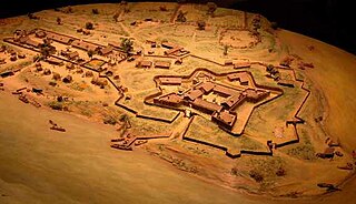
Fort Duquesne was a fort established by the French in 1754, at the confluence of the Allegheny and Monongahela rivers. It was later taken over by the British, and later the Americans, and developed as Pittsburgh in the U.S. state of Pennsylvania. Fort Duquesne was destroyed by the French before its British conquest during the Seven Years' War, known as the French and Indian War on the North American front. The British replaced it, building Fort Pitt between 1759 and 1761. The site of both forts is now occupied by Point State Park, where the outlines of the two forts have been laid in brick.

Interstate 76 (I-76) is an east–west Interstate Highway in the Eastern United States. The highway runs approximately 435.66 miles (701.13 km) from an interchange with I-71 west of Akron, Ohio, east to I-295 in Bellmawr, New Jersey. This route is not contiguous with I-76 in Colorado and Nebraska.

Washington Crossing Historic Park is a 500-acre (2 km2) state park operated by the Pennsylvania Department of Conservation and Natural Resources in partnership with the Friends of Washington Crossing Park. The park is divided into two sections. One section of the park, the "lower park," is headquartered in the village of Washington Crossing located in Upper Makefield Township in Bucks County, Pennsylvania. It marks the location of George Washington's crossing of the Delaware River during the American Revolutionary War.

Warriors Path State Park is a Pennsylvania state park on 349 acres (141 ha) in Liberty Township, Bedford County, Pennsylvania, in the United States. It is named for the Great Indian Warpath that was used by the Iroquois in war raids with the Cherokee and other tribes. Warriors Path State Park is surrounded on three sides by the Raystown Branch Juniata River. The park is a seasonal day use park. The park can be accessed by foot from the main gate when the gate is closed November through mid-April.

This is a list of properties and districts listed on the National Register of Historic Places in Pennsylvania. As of 2015, there are over 3,000 listed sites in Pennsylvania. All 67 counties in Pennsylvania have listings on the National Register.

The Delaware River–Turnpike Toll Bridge is a four-lane, steel through arch bridge crossing the Delaware River between Burlington Township, Burlington County, New Jersey and Bristol Township, Bucks County, Pennsylvania, United States. As a part of Interstate 95 (I-95), it is a major highway link between Philadelphia and New York City. The bridge also connects the Pennsylvania Turnpike's east-west mainline with the main trunk of the New Jersey Turnpike, via the Pearl Harbor Memorial Turnpike Extension. Tolls are collected only in the west/southbound direction via electronic toll collection.

The East River Tunnels are four single-track railroad passenger service tunnels that extend from the eastern end of Pennsylvania Station under 32nd and 33rd Streets in Manhattan and cross the East River to Long Island City in Queens. The tracks carry Long Island Rail Road (LIRR) and Amtrak trains travelling to and from Penn Station and points to the north and east. The tracks also carry New Jersey Transit trains deadheading to Sunnyside Yard. They are part of Amtrak's Northeast Corridor, used by trains traveling between New York City and New England via the Hell Gate Bridge.
Elk State Park is a 3,192-acre (1,292 ha) Pennsylvania state park in Jones Township, Elk County and Sergeant Township, McKean County, Pennsylvania, in the United States. East Branch Clarion River Lake is a man-made lake covering 1,160 acres (470 ha) within the park. The lake and streams in the park are stocked with cold and warm water fish. There are 3,151 acres (1,275 ha) of woods open to hunting.
Tuscarora Creek is a 49.2-mile-long (79.2 km) tributary of the Juniata River in central Pennsylvania in the United States. It rises in eastern Huntingdon County, east of the borough of Shade Gap, and flows northeast between Tuscarora Mountain and Shade Mountain, reaching the Juniata River at Port Royal in Juniata County.

Milton State Park is an 82-acre (33 ha) Pennsylvania state park in the borough of Milton in Northumberland County, Pennsylvania in the United States. The park is on Montgomery Island in the West Branch Susquehanna River, just east of the village of West Milton in Union County. Milton State Park is on Pennsylvania Route 642.

Bucktail State Park Natural Area is a 16,433-acre (6,650 ha) Pennsylvania state park in Cameron and Clinton Counties in Pennsylvania in the United States. The park follows Pennsylvania Route 120 for 75 miles (121 km) between Emporium and Lock Haven. Bucktail State Park Natural Area park runs along Sinnemahoning Creek and the West Branch Susquehanna River and also passes through Renovo. The park is named for the Civil War Pennsylvania Bucktails Regiment and is primarily dedicated to wildlife viewing, especially elk.

Sinnemahoning Creek is a 15.7-mile-long (25.3 km) tributary of the West Branch Susquehanna River in Cameron and Clinton counties, Pennsylvania, in the United States.

U.S. Route 15 (US 15) is United States Numbered Highway that runs from Walterboro, South Carolina, north to Painted Post, New York. In Pennsylvania, the highway runs for 194.89 miles (313.65 km), from the Maryland state line just south of Gettysburg, north to the New York state line near Lawrenceville.
The following outline is provided as an overview of and topical guide to the United States Commonwealth of Pennsylvania:

The Walt Whitman Bridge is a single-level suspension bridge spanning the Delaware River from Philadelphia in the west to Gloucester City in Camden County, New Jersey in the east. The bridge is named after American poet and essayist Walt Whitman, who resided in nearby Camden toward the end of his life.

The Winooski River Bridge, also known locally as the Checkered House Bridge, is a historic Pennsylvania through truss bridge, carrying U.S. Route 2 (US 2) across the Winooski River in Richmond, Vermont. Built in 1929, it is one of only five Pennsylvania trusses in the state, and was the longest bridge built in the state's bridge-building program that followed massive flooding in 1927. The bridge was listed on the National Register of Historic Places in 1990.