
Lancaster County, sometimes nicknamed the Garden Spot of America or Pennsylvania Dutch Country, is a county in the Commonwealth of Pennsylvania. It is located in the south central part of Pennsylvania. As of the 2020 census, the population was 552,984, making it Pennsylvania's sixth-most populous county. Its county seat is Lancaster. Lancaster County comprises the Lancaster, Pennsylvania metropolitan statistical area.

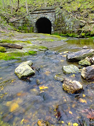
The Bitzer's Mill Covered Bridge is a covered bridge that spans the Conestoga River in Lancaster County, Pennsylvania, United States. It is the oldest bridge in the county still in use. A county-owned and maintained bridge, its official designation is the Big Conestoga #2 Bridge. The bridge is also called Martin's Mill Bridge, Eberly's Cider Mill Covered Bridge, and Fiand's/Fiantz's Covered Bridge.
Conestoga Township is a township in west central Lancaster County, Pennsylvania. At the 2020 census, the population was 3,922.

The Rockville Bridge is the longest stone masonry arch railroad viaduct ever built, at 3,820 feet (1,160 m). It has 48 70-foot spans.

The Conestoga River, also referred to as Conestoga Creek, is a 61.6-mile-long (99.1 km) tributary of the Susquehanna River flowing through the center of Lancaster County, Pennsylvania, United States.

The Smithfield Street Bridge is a lenticular truss bridge crossing the Monongahela River in Pittsburgh, Pennsylvania, USA.

The Delair Bridge is a railroad bridge with a vertical-lift section that crosses the Delaware River between Philadelphia, Pennsylvania, and Pennsauken Township, New Jersey, just south of the Betsy Ross Bridge. The two-track bridge is part of Conrail Shared Assets Operations and is jointly used by Norfolk Southern Railway and CSX Transportation freight trains, as well as by the New Jersey Transit Atlantic City Line service.

George Westinghouse Memorial Bridge in East Pittsburgh, Pennsylvania, carries U.S. Route 30, the Lincoln Highway, over the Turtle Creek Valley near to where it joins the Monongahela River Valley east of Pittsburgh. The reinforced concrete open-spandrel deck arch bridge has a total length of 1,598 feet (487 m) comprising five spans. The longest, central span is 460 feet (140 m), with the deck height 240 feet (73 m) above the valley floor, for a time the world's longest concrete arch span structure. It cost $1.75 million. The design engineers were Vernon R. Covell and George S. Richardson, with architectural design by Stanley Roush. The pylons at the ends of the bridges feature Art Deco reliefs by Frank Vittor.

Conestoga is an unincorporated community and census-designated place (CDP) in Conestoga Township, Lancaster County, Pennsylvania, United States. At the 2010 census, the population was 1,258. The Conestoga post office serves ZIP code 17516.

The Phoenix Iron Works, located in Phoenixville, Pennsylvania, was a manufacturer of iron and related products during the 19th century and early 20th century. Phoenix Iron Company was a major producer of cannon for the Union Army during the American Civil War. The company also produced the Phoenix column, an advance in construction material. Company facilities are a core component of the Phoenixville Historic District, a National Register of Historic Places site that was in 2006 recognized as a historic landmark by ASM International.
Safe Harbor is an unincorporated community located within Conestoga Township in Lancaster County, Pennsylvania, United States.

Dunlap's Creek Bridge was the first arch bridge in the United States built of cast iron. It was designed by Richard Delafield and built by the United States Army Corps of Engineers. Constructed from 1836 to 1839 on the National Road in Brownsville, Pennsylvania, it remains in use today. It is listed on the National Register of Historic Places and is a National Historic Civil Engineering Landmark (1978). It is located in the Brownsville Commercial Historic District and supports Market Street, the local main thoroughfare. Due to the steep sides of the Monongahela River valley, there is only room for two short streets parallel to the river's shore and graded mild enough to be comfortable to walk before the terrain rises too steeply for business traffic.

The Safe Harbor Bridge also known as the Safe Harbor Trestle, Port Road Bridge and the Enola Low Grade Line Steel Trestle is a steel deck truss trestle that spans the Conestoga River at Safe Harbor, Pennsylvania near the Susquehanna River for the Port Road Branch and the former Columbia and Port Deposit Railroad along the Susquehanna River.
Frank Harold Shaw was an American civil engineer notable for designing bridges and water supply infrastructure in Lancaster County, Pennsylvania. Two water towers that he designed, affectionately named "George and Martha" by local residents, were landmarks on the Lancaster skyline until their demolition in 1996.

The Bridge in West Earl Township, as it is designated on the National Register of Historic Places, is also known by its historic name, Big Conestoga Creek Bridge No. 12. It carries Farmersville Road across the Conestoga River at Brownstown, West Earl Township, Pennsylvania, in the United States. The bridge is notable for its form, a three-span, continuous, arched concrete girder that does not touch the abutments. Designer Frank H. Shaw was a consulting engineer to Lancaster County when the bridge was constructed in 1917, but appointed county engineer that same year. The bridge was replaced with a new three-span structure in 2019. It is now known as the Sergeant Melvin R. Wink Memorial Bridge.

The Atglen and Susquehanna Branch is an abandoned branch line of the Pennsylvania Railroad that ran between Lemoyne and Atglen, Pennsylvania. A portion of the line is now the Enola Low Grade Trail.

The Reading-Halls Station Bridge is an historic, American, Howe pony truss railroad bridge that is located in Muncy Township, Lycoming County, Pennsylvania.

The Conestoga Creek Viaduct spans the Conestoga River east of Lancaster, Pennsylvania. The present structure, built in 1887–88, is a five-span, two-track stone arch railroad bridge. The first crossing at this location was a 1,412 feet (430 m) series of 11 wooden Town lattice trusses constructed in 1829 for the Columbia and Philadelphia Railroad, which was purchased by the Pennsylvania Railroad (PRR) and incorporated into its main line in 1857. PRR shortened the viaduct and replaced the remaining wooden trusses with iron Whipple trusses in 1863. The 1887-88 stone arch replacement was originally intended to be four tracks wide, but only half of the superstructure width was constructed, leaving an unfinished spandrel wall on the southern face. Tie rods were added in 1930 to brace the spandrel walls.

The New Hampton Pony Pratt Truss Bridge is a historic pony Pratt truss bridge on Shoddy Mill Road in New Hampton of Lebanon Township, Hunterdon County, New Jersey. It crosses the Musconetcong River between Lebanon Township, Hunterdon County and Washington Township, Warren County. It was designed by Francis C. Lowthorp and built in 1868 by William Cowin of Lambertville, New Jersey. The bridge was added to the National Register of Historic Places on July 26, 1977 for its significance in engineering, industry and transportation. It is one of the few early examples of iron Pratt truss bridges remaining in the United States. It was later documented by the Historic American Engineering Record in 1991. It was added as a contributing property to the New Hampton Historic District on April 6, 1998.
The Main Street Bridge, historically known as the Califon Bridge, is a Pratt thru truss bridge that carries Main Street over the South Branch Raritan River in Califon, Hunterdon County, New Jersey. The bridge was added to the National Register of Historic Places on October 14, 1976, as part of the Califon Historic District.

