List of crossings of the St. Johns River

Last updated

This is a list of bridges and other crossings of the Saint Johns River .

Contents

Crossings

CrossingCarriesMiles to ICWImageLocationCoordinates

Florida

Mayport Ferry Florida A1A.svg SR A1A Mayport FL ferry04.jpg Mayport 30°23′43.3″N81°26′0.88″W / 30.395361°N 81.4335778°W / 30.395361; -81.4335778
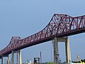
Dames Point Bridge I-295.svg I-295 5.7 Dames point bridge jax march05.jpg Jacksonville 30°23′4.65″N81°33′25.13″W / 30.3846250°N 81.5569806°W / 30.3846250; -81.5569806
Mathews Bridge Alt plate.svg
US 90.svg
Florida 115.svg US 90 Alt.  / SR 115 (Arlington Expressway)
16.1 Mathews Bridge.jpg Jacksonville 30°19′37.98″N81°37′18.07″W / 30.3272167°N 81.6216861°W / 30.3272167; -81.6216861
Hart Bridge Alt plate.svg
US 1.svg
US 1 Alt.
17.3 Hart Bridge, Jacksonville FL Pano Contrast.jpg Jacksonville 30°18′55.72″N81°37′39.48″W / 30.3154778°N 81.6276333°W / 30.3154778; -81.6276333
Main Street Bridge US 1.svgUS 90.svg US 1  / US 90 18.4 Main St Bridge, Jacksonville FL Pano.jpg Jacksonville 30°19′21.34″N81°39′30.86″W / 30.3225944°N 81.6585722°W / 30.3225944; -81.6585722
Acosta Bridge Florida 13.svg SR 13
JTA Skyway
19.6 Jacksonville Acosta Bridge Panorama.jpg Jacksonville 30°19′18.76″N81°39′51.34″W / 30.3218778°N 81.6642611°W / 30.3218778; -81.6642611
Strauss Trunnion Bridge Florida East Coast Railway 19.6 FEC Drawbridge.jpg Jacksonville 30°19′18.63″N81°39′53.98″W / 30.3218417°N 81.6649944°W / 30.3218417; -81.6649944
Fuller Warren Bridge I-95.svg I-95 19.9 Fuller Warren Bridge, Jacksonville FL 2 Panorama.jpg Jacksonville 30°18′55.48″N81°40′19.54″W / 30.3154111°N 81.6720944°W / 30.3154111; -81.6720944
Buckman Bridge I-295.svg I-295 28.8 Buckman Bridge, Jaxsonville FL Panorama 1 3667.jpg Orange Park 30°11′23.93″N81°40′2.44″W / 30.1899806°N 81.6673444°W / 30.1899806; -81.6673444
Shands Bridge Florida 16.svg SR 16 46.0 Shands Bridge St Johns river01.jpg Green Cove Springs 29°59′8.06″N81°37′1.65″W / 29.9855722°N 81.6171250°W / 29.9855722; -81.6171250
Memorial Bridge US 17.svgFlorida 100.svg US 17  / SR 100 73.6 Memorial Bridge (Palatka) pc5771.jpg Palatka to East Palatka 29°38′45.31″N81°37′22.25″W / 29.6459194°N 81.6228472°W / 29.6459194; -81.6228472
Rail bridge CSX Transportation 84.3 Buffalo Bluff 29°35′33″N81°40′51″W / 29.59250°N 81.68083°W / 29.59250; -81.68083
Fort Gates Ferry Fort Gates Ferry Road Fort Gates Ferry.jpg Salt Springs to Welaka 29°26′0″N81°39′50″W / 29.43333°N 81.66389°W / 29.43333; -81.66389
Drayton Island Ferry Drayton Island Road Georgetown to Drayton Island
(partial crossing)
29°23′09″N81°38′17″W / 29.38583°N 81.63806°W / 29.38583; -81.63806
Astor Bridge Florida 40.svg SR 40 120.6 AstorBridge.jpg Astor to Volusia 29°10′03″N81°31′23″W / 29.16750°N 81.52306°W / 29.16750; -81.52306
Francis P. Whitehair Bridge Florida 44.svg SR 44 137.8 DeLand FL St Johns River01.jpg Crows Bluff to DeLand 29°00′31″N81°22′56″W / 29.00861°N 81.38222°W / 29.00861; -81.38222
Rail bridge CSX Transportation Sanford FL RR bridge03.jpg DeBary to Sanford 28°50′16″N81°19′29″W / 28.83778°N 81.32472°W / 28.83778; -81.32472
Benedict Bridge US 17.svgUS 92.svg US 17  / US 92 156.4 CA Bill Benedict Bridge; Memorial Sign.JPG DeBary to Sanford 28°50′15″N81°19′26″W / 28.83750°N 81.32389°W / 28.83750; -81.32389
Lake Monroe Bridge(Closed)Formerly US 17.svgUS 92.svg US 17  / US 92 Lake Monroe Bridge n029717.jpg DeBary to Sanford 28°50′13″N81°19′27″W / 28.83694°N 81.32417°W / 28.83694; -81.32417
Veterans Memorial Bridge I-4.svg I-4 156.7 Interstate4 SJRVMB c60c15eb61 o.jpg DeBary to Sanford 28°50′09″N81°19′09″W / 28.83583°N 81.31917°W / 28.83583; -81.31917
Douglas Stenstrom Bridge Florida 415.svg SR 415 Osteen FL St Johns River bridge03.jpg Sanford to Osteen 28°48′09″N81°12′37″W / 28.80250°N 81.21028°W / 28.80250; -81.21028
Mims Bridge Florida 46.svg SR 46 FL St Johns River Bridge SR 46 west01.jpg Seminole County to Volusia County 28°42′50″N81°02′00″W / 28.71389°N 81.03333°W / 28.71389; -81.03333
Florida 50.svg SR 50 FL 50; Two Bridges over Saint Johns River.JPG Orange County to Brevard County 28°32′34″N80°56′35″W / 28.54278°N 80.94306°W / 28.54278; -80.94306
Beachline Expressway BridgeToll Florida 528.svg SR 528 Orange County to Brevard County 28°27′10.25″N80°53′49.62″W / 28.4528472°N 80.8971167°W / 28.4528472; -80.8971167
Rail Bridge Brightline future extension to Orlando, Florida Orange County to Brevard County
Florida 520.svg SR 520 FL St Johns River Bridge SR 520 east03.jpg Orange County to Brevard County 28°22′10.25″N80°52′22.10″W / 28.3695139°N 80.8728056°W / 28.3695139; -80.8728056
Space Coast ParkwayUS 192.svg US 192 FL St Johns River Bridge US192 west04.jpg 28°5′6.06″N80°45′5.98″W / 28.0850167°N 80.7516611°W / 28.0850167; -80.7516611

See also

Related Research Articles

Dames Point Bridge Bridge in Florida, United States of America

The Dames Point Bridge is a cable-stayed bridge over the St. Johns River in Jacksonville, Florida on the Interstate 295 East Beltway. Construction began in 1985 and was completed in 1989. The main span is 1,300 feet (396.2 m), and is 175 feet (53.3 m) high. The bridge was designed by HNTB Corporation and RS&H, Inc. The Massman Construction Company built the bridge.

Swing bridge Bridge which pivots around the mid-point

A swing bridge is a movable bridge that has as its primary structural support a vertical locating pin and support ring, usually at or near to its center of gravity, about which the turning span can then pivot horizontally as shown in the animated illustration to the right. Small swing bridges as found over canals may be pivoted only at one end, opening as would a gate, but require substantial underground structure to support the pivot.

The Henry Holland Buckman Bridge carries I-295 West Beltway traffic over the St. Johns River in Jacksonville, Florida. It was named for Henry Holland Buckman, a prominent legislator and attorney who was instrumental in establishing the Florida state road system.

Mathews Bridge Bridge in Jacksonville, Florida, United States of America

The Mathews Bridge is a cantilever bridge in Jacksonville, Florida, which spans the St. Johns River. Constructed in 1953, the bridge brings traffic along the Arlington Expressway between downtown Jacksonville and the Arlington neighborhood. It was named after John E. Mathews, a Florida state legislator and Chief Justice of the 1955 Florida Supreme Court who helped gather funding for the bridge's construction. Originally silver in color, the bridge was painted maroon in 1984 in celebration of Jacksonville's United States Football League franchise, the Jacksonville Bulls.

Fuller Warren Bridge Bridge in Florida, United States of America

The Fuller Warren Bridge is the prestressed-concrete girder bridge that carries Interstate 95 (I-95) across the St. Johns River in Jacksonville, Florida. The current structure was finished in October 2002, replacing the original bascule-bridge span, finished in 1954.

The Isaiah David Hart Bridge is a truss bridge that spans the St. Johns River in Jacksonville, Florida. It carries U.S. Route 1 Alternate and State Road 228 (SR 228). It is named after Isaiah Hart, the founder of Jacksonville. It was designed by Sverdrup & Parcel.

Shands Bridge Bridge in Florida, United States of America

The Shands Bridge is a two-lane automobile bridge carrying SR 16 over the St. Johns River south of Jacksonville, Florida.

St. Johns River Veterans Memorial Bridge Bridge in Florida, United States of America

The original St. Johns River Bridge was a four-lane concrete-and-steel causeway bridge constructed over the St. Johns River at the west outlet of Lake Monroe. It is a part of Interstate 4, and spans the border between Seminole and Volusia Counties in Florida, United States. On the Seminole side is Sanford and on the Volusia side is DeBary.

Sidney Lanier Bridge

The Sidney Lanier Bridge is a cable-stayed bridge that spans the Brunswick River in Brunswick, Georgia, carrying four lanes of U.S. Route 17. The current bridge was built as a replacement to the original vertical-lift bridge, which was twice struck by ships. It is currently the longest-spanning bridge in Georgia and is 480 feet (150 m) tall. It was named for poet Sidney Lanier. Each year, there is the "Bridge Run" sponsored by Southeast Georgia Health System when the south side of the bridge is closed to traffic and people register to run the bridge.

Market Street Bridge (Chattanooga) Bridge over the Tennessee River in Chattanooga, Tennessee

The Market Street Bridge, officially referred to as the John Ross Bridge, is a bascule bridge that spans the Tennessee River between downtown Chattanooga, Tennessee, and the Northshore District. It carries North Market Street, and was named in honor of Cherokee Chief John Ross. The bridge was completed in 1917 at a cost of $1.1 million. In the mid-1970s, the southern terminus of US 127 was moved several miles north to the intersection of Dayton Boulevard and Signal Mountain Boulevard in the nearby suburb of Red Bank.

Dexter Coffin Bridge

The Dexter Coffin Bridge is a crossing for Interstate 91 over the Connecticut River north of Hartford, Connecticut, connecting the towns of Windsor Locks, Connecticut and East Windsor, Connecticut. It can be seen from the Windsor Locks Amtrak station.

Edison Bridge (Florida) Bridge in United States of America

The Edison Bridge is the name given to a set of two one-way bridges located in Fort Myers, Florida. Named after inventor Thomas Alva Edison, the two bridges carry each direction of U.S. Highway 41 Business over the Caloosahatchee River, connecting downtown Fort Myers with North Fort Myers.

Joseph E. Muller Bridge Bridge in Massachusetts, Hampden County; Massachusetts

The Joseph E. Muller Bridge is a crossing of the Connecticut River in Western Massachusetts, connecting the communities of Holyoke and South Hadley. The bridge carries U.S. Route 202 (US 202).

Memorial Bridge (Palatka, Florida) Bridge over St. Johns River in Florida, US

Memorial Bridge spans the St. Johns River and connects Palatka to East Palatka, Florida. The bridge is the only permanent vehicle crossing between Green Cove Springs and Astor. As such, the bridge is an important part of connecting the region. Both US 17 and SR 100 use the bridge as a river crossing.

References