Related Research Articles

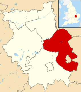
North Yorkshire is a non-metropolitan county and the largest lieutenancy area in England. The ONS estimated that the population of the Shire was 602,300 in mid-2016, excluding unitary authorities.

For local government purposes, Scotland is divided into 32 areas designated as "council areas", which are all governed by single-tier authorities designated as "councils". They have the option under the Local Government (Scotland) Act 1997 of being known as a "comhairle" when opting for a Gaelic name; only Comhairle nan Eilean Siar has chosen this option, whereas the Highland Council has adopted its Gaelic form alongside its English equivalent informally.

Halton is a local government district in the ceremonial county of Cheshire in North West England, with borough status and administered by a unitary authority. It was created in 1974 as a district of the non-metropolitan county of Cheshire, and became a unitary authority area on 1 April 1998 under Halton Borough Council. Since 2014 it has been a member of the Liverpool City Region Combined Authority. The borough consists of the towns of Runcorn and Widnes and the civil parishes of Hale, Daresbury, Moore, Preston Brook, Halebank and Sandymoor. The district borders Merseyside, Warrington and Cheshire West and Chester. The borough straddles the River Mersey – the area to the north is historically part of Lancashire, that to the south part of Cheshire.
East Cambridgeshire is a local government district in Cambridgeshire, England. Its council is based in Ely. The population of the District Council at the 2011 Census was 83,818.

The Borough of Fylde is a local government district with borough status in Lancashire, England. It covers part of the Fylde plain, after which it is named. The council's headquarters are in St Annes. Some council departments, including Planning and an office of the Registrar, were previously located in Wesham, but in 2007 these offices were transferred to the ownership of the NHS North Lancashire Primary Care Trust and have since been replaced by a new housing development. The population of the Non-metropolitan district at the 2011 census was 75,757.
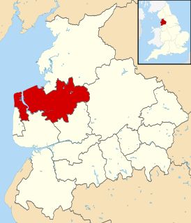
Wyre is a local government district with borough status in Lancashire, England. The population of the non-metropolitan district at the 2011 census was 107,749. The district borders the unitary authority of Blackpool as well as the districts of Lancaster, Ribble Valley, Fylde and Preston. The council is based in Poulton-le-Fylde.
Northern Ireland is divided into 11 districts for local government purposes. In Northern Ireland, local councils do not carry out the same range of functions as those in the rest of the United Kingdom; for example they have no responsibility for education, road-building or housing. Their functions include planning, waste and recycling services, leisure and community services, building control and local economic and cultural development. The collection of rates is handled centrally by the Land and Property Services agency of the Northern Ireland Executive.

The City of Lancaster is a local government district of Lancashire, England, with the status of a city and non-metropolitan district. It is named after its largest settlement, Lancaster, but covers a far larger area, which includes the towns of Morecambe, Heysham, and Carnforth, as well as outlying villages, farms, rural hinterland and a section of the Yorkshire Dales National Park. The district has a population of 146,038 (mid-2019 est.), and an area of 222.5 square miles (576.2 km2).

Belfast City Council is the local authority with responsibility for part of the city of Belfast, the capital and largest city of Northern Ireland. The Council serves an estimated population of 333,871 (2011), the largest of any district council in Northern Ireland, while also being the fourth smallest by area. Belfast City Council is the primary council of the Belfast Metropolitan Area, a grouping of six district councils with commuter towns and overspill from Belfast, containing a total population of 579,276.

Lisburn and Castlereagh is a local government district in Northern Ireland. The district was created on 1 April 2015. It consists of the combined area of the City of Lisburn with the Borough of Castlereagh, but not including "the localities of Gilnahirk, Tullycarnet, Braniel, Castlereagh, Merok, Cregagh, Wynchurch, Glencregagh and Belvoir, Collin Glen, Poleglass, Lagmore, Twinbrook, Kilwee and Dunmurry" which transferred to Belfast. The local authority is Lisburn and Castlereagh City Council.

Derry City and Strabane District Council is the local authority for Derry and Strabane district in Northern Ireland. It was created as part of the 2014 Northern Ireland local government reform, replacing Derry City Council and Strabane District Council. The first elections to the authority were on 22 May 2014 and it acted as a shadow authority to its two predecessors until the new district formally came into being on 1 April 2015. The name was changed from Derry and Strabane City Council on 24 February 2016.

Causeway Coast and Glens is a local government district covering most of the northern part of Northern Ireland. It was created on 1 April 2015 by merging the Borough of Ballymoney, the Borough of Coleraine, the Borough of Limavady and the District of Moyle. The local authority is Causeway Coast and Glens Borough Council.
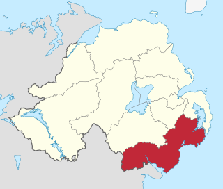
Newry, Mourne and Down is a local government district in Northern Ireland that was created on 1 April 2015 by merging Newry and Mourne District and Down District. It covers most of the southeastern part of Northern Ireland. The local authority is Newry, Mourne and Down District Council.

Armagh City, Banbridge and Craigavon is a local government district in Northern Ireland. The district was created as Armagh, Banbridge and Craigavon on 1 April 2015 by merging the City and District of Armagh, Banbridge District and most of the Borough of Craigavon. The word "City" was added to the name on 24 February 2016, to reflect Armagh's city status. The local authority is Armagh City, Banbridge and Craigavon Borough Council.
References
- ↑ "Population Estimates for UK, England and Wales, Scotland and Northern Ireland, Mid-2019". Office for National Statistics. 6 May 2020. Retrieved 6 May 2020.
- ↑ "Standard Area Measurements (2016) for Administrative Areas in the United Kingdom". Office for National Statistics. 1 February 2017. Retrieved 9 February 2017.