ESPON metropolitan areas in the United Kingdom

Last updated

The 20 largest ESPON metropolitan areas in the UK, ranked by population. Uk-metro-areas.svg
The 20 largest ESPON metropolitan areas in the UK, ranked by population.

A metropolitan area is generally defined as consisting of an urban area, conurbation or agglomeration, together with the surrounding area to which it is closely economically and socially integrated through commuting.

Contents

The European Union's ESPON (European Spatial Planning Observation Network) project defined a harmonised series of metropolitan areas across Europe, made up of two components: Morphological Urban Areas (MUAs), which are similar to urban areas that form the densely populated urban cores of metropolitan areas, and Functional Urban Areas (FUAs), which form the labour basin surrounding Morphological Urban Areas. [1]

Morphological Urban Areas were calculated by combining contiguous local administrative units with population densities greater than 650 inhabitants per square kilometre, with Functional Urban Areas then being calculated by combining surrounding local administrative units where 10% or more of the workforce works within the core Morphological Urban Area. [2]

According to the harmonised European definition, there were eighteen metropolitan areas in the United Kingdom with populations of more than 500,000 at the time of the 2001 census.

This article lists the UK metropolitan areas defined by ESPON, which excluded combined conurbations such as the Liverpool-Manchester megalopolis, which (in 2001) had a combined population of 5.6 million. [3] It also excluded city regions such as those formed in Greater Manchester, Leeds, Liverpool and Sheffield, which are typically areas covered by a combined authority.

Summary

In 2001, there were 46 metropolitan areas in the United Kingdom with a populations in the range 150,000 to 25 million inhabitants, according to the ESPON project, with the following population distribution:

CategoryPopulations (2011)Count
A12.8 – 25 million1
B6.4 – 12.8 million0
C3.2 – 6.4 million1
D1.6 – 3.2 million3
E0.8 – 1.6 million7
F0.4 – 0.8 million9
Gi0.2 – 0.4 million19
Gii<0.2 million~6
Total46

Source[ citation needed ]

By population (2001 data)

Source [4]

#Area (population)Parts (population)
1London (13,709,000) London  (8,265,000) • Southend  (291,000) • Chatham  (231,000) • LutonDunstable  (216,000) • Reading  (216,000) • AldershotFarnborough  (174,000) • Woking  (124,000) • Basildon  (113,000) • Slough  (112,000) • High Wycombe  (100,000) • Crawley  (99,000) • BracknellAscot  (96,000) • Harlow  (87,000) • Chelmsford  (76,000) • Hemel Hempstead  (68,000) • Maidstone  (65,000) • Maidenhead  (59,000) • St. Albans  (59,000) • Basingstoke  (55,000) • Aylesbury  (49,000) • Stevenage  (49,000) • Sittingbourne  (42,000) • Wokingham  (42,000) • Tunbridge Wells  (39,000) • SandhurstYateley  (37,000) • Guildford  (34,000) • Windsor  (33,000) • Bishop's Stortford  (31,000) • Letchworth  (28,000) • Horsham  (27,000) • East Grinstead  (26,000) • Burgess Hill  (24,000) • Sevenoaks  (24,000) • Haywards Heath  (22,000) • Hitchin  (21,000) • Tonbridge  (20,000)
2Birmingham (3,683,000) Birmingham–Wolverhampton  (2,363,000) • Coventry  (308,000) • Nuneaton  (87,000) • WarwickLeamington  (71,000) • Redditch  (61,000) • Bromsgrove  (25,000) • Tamworth  (21,000)
3Manchester (2,556,000) Greater Manchester Urban Area  (2,207,000) • Macclesfield  (59,000)
4Leeds–Bradford (2,302,000) Leeds  (534,000) • Bradford  (341,000) • Huddersfield  (219,000) • HalifaxQueensbury  (155,000) • Wakefield  (111,000) • CastlefordPontefract  (102,000) • Harrogate  (60,000) • Dewsbury  (36,000)
5Liverpool-Birkenhead (2,241,000) LiverpoolBirkenhead  (1,170,000) • WiganAshton  (220,000) • Warrington  (168,000) • WidnesRuncorn  (121,000) • Chester  (58,000) • Southport  (44,000) • Ellesmere Port  (40,000) • Ormskirk  (24,000) • Skelmersdale  (20,000)
6Newcastle–Sunderland (1,599,000) Newcastle  (814,000) • Sunderland  (270,000) • BlythCramlington  (55,000) • Peterlee  (42,000) • Ashington  (27,000) • Seaham  (24,000) • Chester-le-Street  (23,000)
7Sheffield (1,569,000) Sheffield  (693,000) • Rotherham  (150,000) • Doncaster  (80,000) • Darfield  (73,000) • Chesterfield  (73,000) • Barnsley  (56,000)
8Portsmouth–Southampton (1,547,000) Portsmouth  (500,000) • Southampton  (376,000) • Bognor Regis  (66,000) • Salisbury  (29,000) • Winchester  (27,000) • Andover  (26,000)
9Nottingham–Derby (1,534,000) Nottingham  (532,000) • Derby  (217,000) • Mansfield  (185,000) • Ilkeston  (53,000) • Newark  (25,000) • Alfreton  (23,000)
10Glasgow (1,395,000) Greater Glasgow  (1,228,000) • East Kilbride  (59,000) • Cumbernauld  (45,000) • Kilmarnock  (39,000) • Dumbarton  (23,000)
11Cardiff and South Wales valleys (1,097,000) Cardiff  (353,000) • Newport  (192,000) • Merthyr Tydfil  (35,000) • Pontypridd  (28,000) • Caerphilly  (26,000) • Bridgend  (24,000) • Ebbw Vale  (22,000)
12Bristol (1,041,000) Bristol  (568,000) • Weston-super-Mare  (70,000) • Bath  (65,000) • Clevedon  (25,000)
13Belfast (799,000) Belfast  (501,000) • Bangor  (15,000)
14Edinburgh (782,000) Edinburgh  (478,000) • Livingston  (46,000)
15Brighton–Worthing–Littlehampton (769,000) BrightonWorthing  (410,000) • Eastbourne  (74,000) • Littlehampton  (40,000)
16Leicester (745,000) Leicester  (442,000) • Loughborough  (53,000) • Coalville  (39,000) • Hinckley  (20,000)
17Middlesbrough (656,000) Middlesbrough-Stockton  (389,000) • Darlington  (58,000) • Hartlepool  (53,000)
18Bournemouth–Poole (531,000) BournemouthPoole  (390,000)
19Swansea (462,000) Swansea  (219,000) • Port TalbotNeath  (51,000)
20Stoke (456,000) Stoke-on-Trent  (359,000)
21Hull (419,000) Hull  (284,000)
22Blackburn–Burnley (391,000) Blackburn  (182,000) • Burnley  (125,000)
23Norwich (364,000) Norwich  (193,000)
24Preston (354,000) PrestonLeyland  (249,000)
25Plymouth (343,000) Plymouth  (228,000)
26Aberdeen (332,000) Aberdeen  (183,000)
27Blackpool (304,000) Blackpool  (239,000)
28Northampton (288,000) Northampton  (220,000)
29Cambridge (283,000) Cambridge  (142,000)
30Milton Keynes (271,000) Milton Keynes  (136,000)
31Swindon (260,000) Swindon  (144,000)
32Exeter (259,000) Exeter  (105,000) • Exmouth  (25,000)
33Oxford (244,000) Oxford  (122,000)
34Ipswich (240,000) Ipswich  (120,000)
35York (234,000) York  (135,000)
36Torbay (231,000) Torbay  (178,000)
37Peterborough (219,000) Peterborough  (127,000)
38Dundee (211,000) Dundee  (150,000)
39Telford (209,000) Telford  (105,000)
40Bedford (202,000) Bedford  (108,000)
41Colchester (191,000) Colchester  (95,000)
42Lincoln (176,000) Lincoln  (99,000)
43Grimsby (174,000) Grimsby  (123,000)
44Gloucester (166,000) Gloucester  (134,000)
45Hastings–Bexhill (164,000) HastingsBexhill  (103,000)
46Cheltenham (164,000) Cheltenham  (82,000)

By region (2001 data)

Region Region population
[ citation needed ]
Metro RankMetropolitan areaMetro Population (2001)
Greater London 8,173,9411London13,709,000
West Midlands 5,601,8472Birmingham3,683,000
20Stoke456,000
39Telford209,000
North West 7,052,1773Manchester2,556,000
5Liverpool–Birkenhead2,241,000
22Blackburn–Burnley391,000
24Preston354,000
27Blackpool304,000
Yorkshire and the Humber 5,283,7334Leeds–Bradford2,302,000
7Sheffield1,569,000
21Hull419,000
35York234,000
43Grimsby174,000
North East 2,596,8866Newcastle–Sunderland1,599,000
17Middlesbrough656,000
South East 8,634,7508Portsmouth–Southampton1,547,000
15Brighton–Worthing–Littlehampton769,000
30Milton Keynes271,000
33Oxford244,000
45Hastings–Bexhill164,000
East Midlands 4,533,2229Nottingham–Derby1,543,000
16Leicester745,000
28Northampton288,000
42Lincoln176,000
Wales 11Cardiff and South Wales valleys1,097,000
19Swansea462,000
South West 5,288,93512Bristol1,041,000
18Bournemouth–Poole531,000
25Plymouth343,000
31Swindon260,000
32Exeter259,000
36Torbay231,000
44Gloucester166,000
46Cheltenham164,000
East of England 5,846,96523Norwich364,000
29Cambridge283,000
34Ipswich240,000
37Peterborough219,000
40Bedford202,000
41Colchester191,000
Scotland 5,404,70010Glasgow1,395,000
14Edinburgh782,000
26Aberdeen332,000
38Dundee211,000
Northern Ireland 13Belfast799,000

See also

Related Research Articles

<span class="mw-page-title-main">Metropolitan area</span> Administrative unit of a dense urban core and its satellite cities

A metropolitan area or metro is a region consisting of a densely populated urban agglomeration and its surrounding territories sharing industries, commercial areas, transport network, infrastructures and housing. A metropolitan area usually comprises multiple principal cities, jurisdictions and municipalities: neighborhoods, townships, boroughs, cities, towns, exurbs, suburbs, counties, districts and even states and nations in areas like the eurodistricts. As social, economic and political institutions have changed, metropolitan areas have become key economic and political regions.

<span class="mw-page-title-main">Conurbation</span> Group of settlements linked by continuous urban area

A conurbation is a region comprising a number of metropolises, cities, large towns, and other urban areas which, through population growth and physical expansion, have merged to form one continuous urban or industrially developed area. In most cases, a conurbation is a polycentric urbanised area in which transportation has developed to link areas. They create a single urban labour market or travel to work area.

<span class="mw-page-title-main">Upper Silesian-Moravian metropolitan area</span> Place

The Upper Silesian-Moravian metropolitan area is a polycentric metropolitan area in southern Poland and northeastern Czech Republic, centered on the cities of Katowice and Ostrava, and has around 5 million inhabitants. Geographically, it is located mainly in Upper Silesia, with small parts of the area also in the historical regions of Moravia and Lesser Poland. Administratively, it is located in the three administrative units : mainly Silesian Voivodeship and a small western part of Lesser Poland Voivodeship in Poland, and also a small eastern part of Moravian-Silesian Region in Czechia.

<span class="mw-page-title-main">London metropolitan area</span> Region of England

The London metropolitan area is the metropolitan area of London, England. It has several definitions, including the London Travel to Work Area, and usually consists of the London urban area, settlements that share London's infrastructure, and places from which it is practicable to commute to work in London. It is also known as the London commuter belt, or Southeast metropolitan area.

<span class="mw-page-title-main">Nottingham Urban Area</span> Area of land in and around Nottingham, England

The Nottingham Built-up Area (BUA), Nottingham Urban Area, or Greater Nottingham is an area of land defined by the Office for National Statistics as which is built upon, with nearby areas linked if within 200 metres. It consists of the city of Nottingham and the adjoining urban areas of Nottinghamshire and Derbyshire, in the East Midlands of England. It had a total population of 729,977 at the time of the 2011 census. This was an increase of almost 10% since the 2001 census recorded population of 666,358, due to population increases, reductions and several new sub-divisions.

<span class="mw-page-title-main">South Hampshire</span> Conurbation in Hampshire, southern England

South Hampshire is a term used mainly to refer to the conurbation formed by the city of Portsmouth, city of Southampton and the non-metropolitan boroughs of Gosport, Fareham, Havant and Eastleigh in southern Hampshire, South East England. The area was estimated to have a population of over 1.5 million in 2013. It is the most populated part of South East England excluding London. The area is sometimes referred to as Solent City particularly in relation to local devolution, but the term is controversial.

Farnborough/Aldershot built-up area and Aldershot Urban Area are names used by the Office for National Statistics (ONS) to refer to a conurbation spanning the borders of Surrey, Berkshire and Hampshire in England. The ONS found a population of 252,937 in 2011. This makes it the 29th-largest built-up area in England.
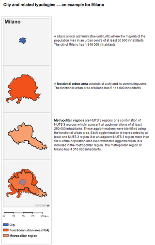
The larger urban zone (LUZ), or functional urban area (FUA), is a measure of the population and expanse of metropolitan and surrounding areas which may or may not be exclusively urban. It consists of a city and its commuting zone outside it.

<span class="mw-page-title-main">Radzionków</span> Place in Silesian Voivodeship, Poland

Radzionków is a town in Silesia in southern Poland, near Katowice. Borders on the Upper Silesian Metropolitan Union – metropolis with the population of 2 million. Located in the Silesian Highlands.

<span class="mw-page-title-main">Luton/Dunstable urban area</span> Conurbation in Bedfordshire, England, which includes Luton, Dunstable and Houghton Regis

The Luton/Dunstable urban area, according to the Office for National Statistics, is the conurbation including the settlements of Luton, Dunstable and Houghton Regis, in Bedfordshire, East of England.

<span class="mw-page-title-main">Miasteczko Śląskie</span> Place in Silesian Voivodeship, Poland

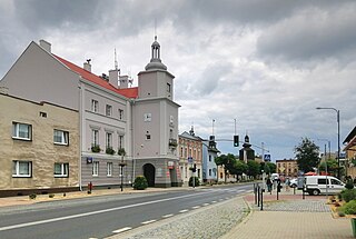
Miasteczko Śląskie is a small town in Upper Silesia in southern Poland, near Katowice. Borders on the Upper Silesian Metropolitan Union - metropolis with the population of 2 million. Located in the Silesian Highlands.

<span class="mw-page-title-main">Naples metropolitan area</span> Metropolitan area in Campania, Italy

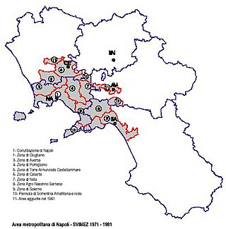
The Naples metropolitan area, or Greater Naples, is a metropolitan area in Campania, Italy, centered on the city of Naples.

<span class="mw-page-title-main">Katowice urban area</span> Silesian conurbation and largest urban area in Poland

The Katowice urban area, also known as the Upper Silesian urban area, is an urban area/conurbation in southern Poland, centered on Katowice. It is located in the Silesian Voivodeship and in a small part of the Lesser Poland Voivodeship. The Katowice urban area is the largest urban area in Poland and one of the largest in the European Union.

<span class="mw-page-title-main">Ostrava metropolitan area</span> Urban area in Czechia

The Ostrava metropolitan area is the metropolitan area with the city of Ostrava in the Czech Republic at its center. The Ostrava urban area is the largest urban area in the metropolitan area with a population of 365,000. The metropolitan area corresponds to the administrative Moravian-Silesian Region. The population of the metropolitan area is 966,175 as of 2023. An alternative definition, the Eurostat Larger Urban Zone, lists a population of 1,153,876. The Ostrava metropolitan area is sometimes combined with the Katowice metropolitan area to form a wider metropolitan area with a population of 5,008,000 (2015). The metropolitan area has 172 municipalities.

<span class="mw-page-title-main">Metropolitan areas in Poland</span>

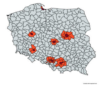
This is a list of metropolitan areas in Poland.

The Cardiff-Newport metropolitan area is a metropolitan area in South East Wales in the Gwent and South Glamorgan counties of Wales, United Kingdom. The metropolitan area includes the cities of Cardiff and Newport, along with a number of towns in the South Wales Valleys, including Merthyr Tydfil, Pontypridd, Caerphilly, Bridgend and Ebbw Vale. With these outlying settlements the metropolitan area has a population of 1.09 million.

<span class="mw-page-title-main">Vienna-Bratislava metropolitan region</span> Metropolitan region

The Vienna-Bratislava metropolitan region is one of 5 polycentric conurbations in European Union. It has population of over 4 million inhabitants and covers an area of around 14,000 square kilometres (5,400 sq mi). It is located in seven administrative units.

References

  1. "MUAs and FUAs delineation" (PDF). ESPON project 1.4.3 Study on Urban Functions. European Spatial Planning Observation Network. March 2007. p. 8. Retrieved 22 February 2010.
  2. "The methodology" (PDF). ESPON project 1.4.3 Study on Urban Functions. European Spatial Planning Observation Network. March 2007. p. 17. Retrieved 22 February 2010.
  3. Schulze Bäing, Andreas. "Shrinking cities and growing regions – emerging trends of new rural-urban relationships in the UK and Germany". 13 July. AESOP University of Manchester. Retrieved 19 March 2015.
  4. "British urban pattern: population data" (PDF). ESPON project 1.4.3 Study on Urban Functions. European Spatial Planning Observation Network. March 2007. p. 119. Retrieved 8 March 2019.