
County Fermanagh is one of the thirty-two counties of Ireland, one of the nine counties of Ulster and one of six counties of Northern Ireland
County Wicklow is a county in Ireland. The last of the traditional 32 counties, having been formed as late as 1606, it is part of the Eastern and Midland Region and the province of Leinster. It is bordered by the Irish Sea to the east and the counties of Wexford to the south, Carlow to the southwest, Kildare to the west, and South Dublin and Dún Laoghaire–Rathdown to the north.
County Londonderry, also known as County Derry, is one of the six counties of Northern Ireland, one of the thirty-two counties of Ireland and one of the nine counties of Ulster. Before the partition of Ireland, it was one of the counties of the Kingdom of Ireland from 1613 onward and then of the United Kingdom after the Acts of Union 1800. Adjoining the north-west shore of Lough Neagh, the county covers an area of 2,118 km2 (818 sq mi) and today has a population of about 252,231.
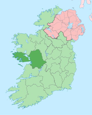
County Galway is a county in Ireland. It is in the Northern and Western Region, taking up the south of the province of Connacht. The county population was 276,451 at the 2022 census.
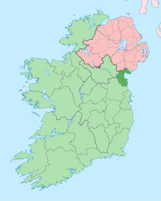
County Louth is a coastal county in the Eastern and Midland Region of Ireland, within the province of Leinster. Louth is bordered by the counties of Meath to the south, Monaghan to the west, Armagh to the north and Down to the north-east, across Carlingford Lough. It is the smallest county in Ireland by land area and the 17th most populous, with just over 139,100 residents as of 2022. The county is named after the village of Louth. Louth County Council is the local authority for the county.
Local government in Northern Ireland is divided among 11 districts. Councils in Northern Ireland do not carry out the same range of functions as those in the rest of the United Kingdom; for example they have no responsibility for education, road-building or housing. Their functions include planning, waste and recycling services, leisure and community services, building control and local economic and cultural development. The collection of rates is handled centrally by the Land and Property Services agency of the Northern Ireland Executive.

Bradford, also known as the City of Bradford, is a metropolitan borough in West Yorkshire, England. It is named after its largest settlement, Bradford, but covers a larger area which includes the towns and villages of Keighley, Shipley, Bingley, Ilkley, Haworth, Silsden, Queensbury, Thornton and Denholme. Bradford has a population of 528,155, making it the fourth-most populous metropolitan district and the sixth-most populous local authority district in England. It forms part of the West Yorkshire Urban Area conurbation which in 2011 had a population of 1,777,934, and the city is part of the Leeds-Bradford Larger Urban Zone (LUZ), which, with a population of 2,393,300, is the fourth largest in the United Kingdom after London, Birmingham and Manchester.

Maghera is a small town at the foot of the Glenshane Pass in Northern Ireland. Its population was 4,235 in the 2021 Census. Formerly in the barony of Loughinsholin within the historic County Londonderry, it is today in the local-government district of Mid-Ulster.

Belfast City Council is the local authority with responsibility for part of Belfast, the largest city of Northern Ireland. The council serves an estimated population of 345,006 (2019), the largest of any district council in Northern Ireland, while being the smallest by area. Belfast City Council is the primary council of the Belfast Metropolitan Area, a grouping of six former district councils with commuter towns and overspill from Belfast, containing a total population of 579,276.

Omagh District Council was a local council in Northern Ireland. It merged with Fermanagh District Council in April 2015 under local government reorganisation to become Fermanagh and Omagh District Council.
An electoral division is a legally defined administrative area in the Republic of Ireland, generally comprising multiple townlands, and formerly a subdivision of urban and rural districts. Until 1996, EDs were known as district electoral divisions in the 29 county council areas and wards in the five county boroughs. Until 1972, DEDs also existed in Northern Ireland. The predecessor poor law electoral divisions were introduced throughout the island of Ireland in the 1830s. The divisions were used as local-government electoral areas until 1919 in what is now the Republic and until 1972 in Northern Ireland.
Christianity is the largest religion in Northern Ireland. In the 2021 census, 79.7% of the Northern Irish population identified as Christians: Catholic (42.3%); Presbyterian (16.6%); Church of Ireland (11.5%); Methodist (2.4%); Other Christian (6.9%). Meanwhile, 1.3% of the population belonged to other religions, 17.4% stated they were non-religious and 1.5% did not state a religious or non-religious identity. The Catholic Church has seen a small growth in adherents, while the other recorded Christian groups have seen a small decrease.
The Belfast metropolitan area, also known as Greater Belfast, is a grouping of council areas which include commuter towns and overspill from Belfast, Northern Ireland, with a population of 672,522 in 2011, combining the Belfast, Lisburn, Newtownabbey, North Down, Castlereagh and Carrickfergus districts. This equates to 37.1% of Northern Ireland's population.
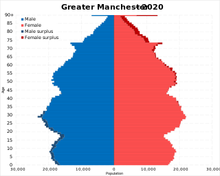
The demography of Greater Manchester is analysed by the Office for National Statistics and data is produced for each of its ten metropolitan boroughs, each of the Greater Manchester electoral wards, the NUTS3 statistical sub-regions, each of the Parliamentary constituencies in Greater Manchester, the 15 civil parishes in Greater Manchester, and for all of Greater Manchester as a whole; the latter of which had a population of 2,682,500 at the 2011 UK census. Additionally, data is produced for the Greater Manchester Urban Area. Statistical information is produced about the size and geographical breakdown of the population, the number of people entering and leaving country and the number of people in each demographic subgroup.
A census of the population of the United Kingdom is taken every ten years. The 2011 census was held in all counties of the UK on 27 March 2011. It was the first UK census which could be completed online via the Internet. The Office for National Statistics (ONS) is responsible for the census in England and Wales, the General Register Office for Scotland (GROS) is responsible for the census in Scotland, and the Northern Ireland Statistics and Research Agency (NISRA) is responsible for the census in Northern Ireland.

Leeds, England is the third most populous city in the United Kingdom.

White: Gypsy or Irish Traveller is an ethnicity classification used in the 2011 United Kingdom Census. In the 2011 census, the White: Gypsy or Irish Traveller population was 63,193 or about 0.1 per cent of the total population of the country. The ethnicity category may encompass populace from the distinct ethnic groups of Romanichal Travellers or Irish Travellers, and their respective related subgroupings, who identify as, or are perceived to be, white people in the United Kingdom.