Craigavon Borough
| |
---|---|
Area | 378 km2 (146 sq mi) Ranked 19th of 26 |
District HQ | Craigavon |
Country | Northern Ireland |
Sovereign state | United Kingdom |
Website | www |
Craigavon Borough Council was a local council in counties Armagh, Down and Antrim, in Northern Ireland. It merged with Armagh City and District Council and Banbridge District Council in May 2015 under local government reorganisation in Northern Ireland to become Armagh, Banbridge and Craigavon District Council.
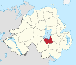
The headquarters of the council were in Craigavon, on the shores of Lough Neagh, a new town built between Lurgan and Portadown. The council area included the large towns of Lurgan and Portadown, as well as smaller ones including Waringstown and Donaghcloney. The average council budget of £15.5 million provided a wide range of services to the 93,023 people living in the area.
The council area consisted of four electoral areas – Central, Loughside, Lurgan and Portadown – in which 26 councillors were elected every four years. The council held an annual meeting in June, at which a new Mayor and Deputy Mayor were elected. Parties elected in 2011, the last elections for the council, were Democratic Unionist Party (DUP) nine seats, Sinn Féin eight, Ulster Unionist Party (UUP) six, Social Democratic and Labour Party (SDLP) four, and Alliance Party of Northern Ireland one.
The last election was due to take place in May 2009, but on 25 April 2008, Shaun Woodward, Secretary of State for Northern Ireland announced that the scheduled 2009 district council elections were to be postponed until the introduction of the eleven new councils in 2011. [1] The proposed reforms were abandoned in 2010, and the 2011 Northern Ireland local elections took place to fill the last body on the council before being dissolved [2] The proposed reform took effect on 1 April 2015.
Together with part of the district of Banbridge, it was part of the Upper Bann constituency for elections to the Westminster Parliament and Northern Ireland Assembly.
1973 | 1977 | 1981 | 1985 | 1989 | 1993 | 1997 | 2001 | 2005 | 2011 | |
---|---|---|---|---|---|---|---|---|---|---|
Ulster Unionist (UUP) | 11 | 10 | 9 | 11 | 12 | 10 | 11 | 8 | 6 | 6 |
Alliance (APNI) | 4 | 3 | 1 | 2 | 2 | 1 | 1 | |||
Vanguard (VUPP) | 4 | |||||||||
Democratic Unionist (DUP) | 3 | 4 | 7 | 6 | 4 | 4 | 3 | 6 | 9 | 9 |
Social Democratic and Labour Party (SDLP) | 2 | 6 | 5 | 5 | 6 | 6 | 7 | 7 | 4 | 2 |
Independent Nationalist (IN) | 1 | 2 | ||||||||
United Ulster Unionist (UUUP) | 1 | 1 | ||||||||
Workers' Party (WP) | 1 | 2 | 2 | 1 | 1 | |||||
Sinn Féin (SF) | 2 | 1 | 2 | 2 | 4 | 6 | 8 | |||
Independent Unionist (IU) | 1 | 1 | 1 | |||||||
Note: The Workers' Party were known as The Republican Clubs in 1977 and Workers Party Republican Clubs in 1981.
Source: Freedom of Information request to Craigavon Borough Council
Below is a list of members who made up the final sitting of the council before it was dissolved.
Name | Party | |
---|---|---|
Jonathan Buckley | DUP | |
Phil Moutray | DUP | |
Robert Smith | DUP | |
Mark Baxter | DUP | |
Margaret Tinsley | DUP | |
Alan Carson | DUP | |
Darryn Causby | DUP | |
Gladys McCullough | DUP | |
Carla Lockhart | DUP | |
Catherine Seeley | Sinn Féin | |
Mark O'Dowd | Sinn Féin | |
Liam Mackle | Sinn Féin | |
Mairead O'Dowd | Sinn Féin | |
Paul Duffy | Sinn Féin | |
Gemma McKenna | Sinn Féin | |
Thomas O'Connor | Sinn Féin | |
Noel McGeown | Sinn Féin | |
Kyle Savage | Ulster Unionist | |
Arnold Hatch | Ulster Unionist | |
Ronald Harkness | Ulster Unionist | |
Colin McCusker | Ulster Unionist | |
Meta Crozier | Ulster Unionist | |
Kenneth Twyble | Ulster Unionist | |
Declan McAlinden | SDLP | |
Joseph Nelson | SDLP | |
Conrad Dixon | Alliance |
The area covered by Craigavon Borough Council had a population of 93,023 residents according to the 2011 Northern Ireland census. [4]
County Armagh is one of the six counties of Northern Ireland and one of the traditional thirty-two counties of Ireland. Adjoined to the southern shore of Lough Neagh, the county covers an area of 1,327 km2 (512 sq mi) and has a population of about 175,000. County Armagh is known as the "Orchard County" because of its many apple orchards. The county is part of the historic province of Ulster.
Lurgan is a town in County Armagh, Northern Ireland, near the southern shore of Lough Neagh. Lurgan is about 18 miles (29 km) south-west of Belfast and is linked to the city by both the M1 motorway and the Belfast–Dublin railway line. It had a population of about 28,634 at the 2021 UK census and is within the Armagh, Banbridge and Craigavon district. For some purposes, Lurgan is treated as part of the "Craigavon Urban Area" along with neighbouring Craigavon and Portadown.
Portadown is a town in County Armagh, Northern Ireland. The town sits on the River Bann in the north of the county, about 24 mi (39 km) southwest of Belfast. It is in the Armagh City, Banbridge and Craigavon Borough Council area and had a population of about 22,000 at the 2011 Census. For some purposes, Portadown is treated as part of the "Craigavon Urban Area", alongside Craigavon and Lurgan.
Craigavon is a town in northern County Armagh, Northern Ireland. Its construction began in 1965 and it was named after the first Prime Minister of Northern Ireland: James Craig, 1st Viscount Craigavon. It was intended to be the heart of a new linear city incorporating Lurgan and Portadown, but this plan was mostly abandoned and later described as having been flawed. Among local people today, "Craigavon" refers to the area between the two towns. It is built beside a pair of artificial lakes and is made up of a large residential area (Brownlow), a second smaller one (Mandeville), plus a central area (Highfield) that includes a substantial shopping centre, a courthouse and the district council headquarters. The area around the lakes is a public park and wildlife haven made up of woodland with walking trails. There is also a watersports centre, golf course and ski slope in the area. In most of Craigavon, motor vehicles are completely separated from pedestrians, and roundabouts are used extensively. It hosted the headquarters of the former Craigavon Borough Council.
Upper Bann is a parliamentary constituency in Northern Ireland, which is represented in the United Kingdom House of Commons. The current MP is Carla Lockhart of the DUP.
Armagh City and District Council was a district council in County Armagh in Northern Ireland. It merged with Banbridge District Council and Craigavon Borough Council in May 2015 under local government reorganisation in Northern Ireland to become Armagh, Banbridge and Craigavon District Council.
Banbridge was a local government district in Northern Ireland. The district was one of 26 council areas formed on 1 October 1973, following the implementation of the Local Government Act 1972. The headquarters of the council were in the town of Banbridge. In April 2015, most of the Banbridge district was included in the merged Armagh, Banbridge and Craigavon district. Some smaller areas in the east of the district became merged with the Newry, Mourne and Down District
James Harold McCusker was a Northern Ireland Ulster Unionist Party politician who served as the Deputy Leader of the UUP Assembly Group from 1982 to 1986.
Derryadd is a hamlet and townland in County Armagh, Northern Ireland. It is within the Armagh City, Banbridge and Craigavon Borough Council area, on the southern shores of Lough Neagh. In the 2001 Census it had a population of 201 people.
The Birches is a small village in northern County Armagh, Northern Ireland. It is 6 miles northwest of Portadown, close to junction 12 on the M1 Motorway and to the southern shore of Lough Neagh. In the 2001 Census it had a population of 150. It is within the Armagh City, Banbridge and Craigavon council area.
Derrywarragh Island is a boulder clay island on Lough Neagh, Northern Ireland. It is linked by a bridge to Maghery, County Armagh. The island is approximately 13 kilometres (8 mi) northwest of Portadown. Most of the island is wet grassland. There are also areas of wet woodland, marshes and swamps. The island is also regularly the home of wintering and breeding birds.
Craigavon Area Hospital is a teaching hospital in Portadown, Craigavon, County Armagh, Northern Ireland. It serves an estimated 241,000 people from the boroughs/districts of Craigavon, Banbridge, Armagh and Dungannon–South Tyrone. It is managed by the Southern Health and Social Care Trust and is located within the townland of Lisnisky, beside the A27 road, at the north-eastern edge of Portadown.
Bannfoot is a small village in the townland of Derryinver, County Armagh, Northern Ireland. It sits where the Upper Bann flows into Lough Neagh.
Armagh City, Banbridge and Craigavon is a local government district in Northern Ireland. The district was created as Armagh, Banbridge and Craigavon on 1 April 2015 by merging the City and District of Armagh, Banbridge District and most of the Borough of Craigavon. The word "City" was added to the name on 24 February 2016, to reflect Armagh's city status. The local authority is Armagh City, Banbridge and Craigavon Borough Council.
Maghery Country Park is a park in the village of Maghery, County Armagh, Northern Ireland, on the shores of Lough Neagh. It covers 30 acres (120,000 m2) and includes five km of woodland walks and picnic areas and is used for birdwatching, fishing, and walking. Coney Island lies one km off shore and boat trips are available from the park at weekends. It is an important local amenity and tourist attraction and is managed by Armagh City, Banbridge and Craigavon Borough Council.
Banbridge District Council was the local authority of Banbridge in Northern Ireland. It was created in 1973 when the Local Government (Boundaries) Act 1971 came into force. In May 2015, it merged with Armagh City and District Council and Craigavon Borough Council to form one of 11 new local government units. The new council area was named Armagh, Banbridge and Craigavon District Council.
Oxford Island is a National Nature Reserve and public recreation site on the southern shores of Lough Neagh at Lurgan, County Armagh. The site covers 282 acres and is owned and maintained by Armagh City, Banbridge and Craigavon Borough Council. Much of the area is designated as a National Nature Reserve due to its wide variety of natural habitats. The purpose of all work on the island is to maintain biodiversity and to provide a recreation area for everyone.
Armagh City, Banbridge and Craigavon Borough Council is a local authority that was established on 1 April 2015. It replaced Armagh City and District Council, Banbridge District Council and Craigavon Borough Council. The first elections to the authority were on 22 May 2014 and it acted as a shadow authority, before the Armagh, Banbridge and Craigavon district was created on 1 April 2015.
The first election to Armagh City, Banbridge and Craigavon Borough Council, part of the Northern Ireland local elections on 22 May 2014, returned 41 members to the newly-formed council via Single Transferable Vote. The Democratic Unionist Party won a plurality of seats, although the Ulster Unionist Party attracted the most first-preference votes.