This is a list of earthquakes that have occurred in the Italian seismic district of Irpinia since the 15th century. It comprises all of the significant earthquakes whose epicenter was located in Irpinia, not those whose epicenter was outside the area, but may have still have an effect on it. The death toll includes the total number of deaths as a result of the earthquake, not only those that occurred in Irpinia.
| Date | Name | Epicenter | Magnitude | Deaths | Ref. |
|---|---|---|---|---|---|
| December 5, 1456 | 1456 Central Italy earthquakes | Unknown | 7.4 Mw | 30,000–40,000 | [1] [2] |
| January 15, 1466 | 1466 Irpinia earthquake | South of the Sella di Conza pass in Monti Eremita – Marzano in the southern Apennines | 6.5 Mw | Hundreds | [1] |
| March 29, 1517 | 1517 Irpinia earthquake | Between the Formicoso plateau and Baronia | 5.4 ML | 26+ | |
| September 8, 1694 | 1694 Irpinia–Basilicata earthquake | Head of the Ofanto River | 6.87 ML | 6,000 | |
| March 14, 1702 | 1702 Irpinia–Benevento earthquake | Middle of the Calore valley, east of Benevento | 4.9 ML | 400 | |
| November 29, 1732 | 1732 Irpinia earthquake | Grottaminarda | 6.6 Mw | Thousands | |
| April 9, 1853 | 1853 Irpinia earthquake | Near the Sele in southern Irpinia | 5.6 ML | Around 12 | |
| June 7, 1910 | 1910 Irpinia earthquake | Calitri | 5.7 ML | 50 | |
| July 23, 1930 | 1930 Irpinia earthquake | Between Lacedonia and Bisaccia | 6.7 Mw | 1404 | |
| August 21, 1962 | 1962 Irpinia earthquake | Between Valle del Miscano and the Ufita River in northern Irpinia | 6.1 ML | 17 | |
| November 23, 1980 | 1980 Irpinia earthquake | Upper Sele Valley | 6.9 Mw | 2,914 | [1] |

An earthquake – also called a quake, tremor, or temblor – is the shaking of the Earth's surface resulting from a sudden release of energy in the lithosphere that creates seismic waves. Earthquakes can range in intensity, from those so weak they cannot be felt, to those violent enough to propel objects and people into the air, damage critical infrastructure, and wreak destruction across entire cities. The seismic activity of an area is the frequency, type, and size of earthquakes experienced over a particular time. The seismicity at a particular location in the Earth is the average rate of seismic energy release per unit volume.

Nusco is a town and comune in the province of Avellino in the south of Italy, east of Naples, with a population of around 4,100. It is situated in the mountains between the valleys of the Calore Irpino and Ofanto rivers. It is one of I Borghi più belli d'Italia.
Calabritto is an Italian town and a commune in the province of Avellino, Campania, Italy. It occupies a hilly-mountainous area at the eastern tip of the Monti Picentini range, in the upper Sele valley.

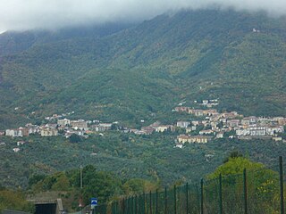
Guardia Lombardi, known as La Uàrdia in the Irpinian dialect, is a small town and comune in the Province of Avellino in Campania, Italy. At an elevation of 998 metres (3,274 ft), it is located in Irpinia in the Apennine Mountains of Southern Italy. It has experienced a number of major earthquakes throughout its history that have devastated the town, and is considered within zone 1 of the Protezione Civile's seismic classification index, indicating very high seismicity.
The 2006 Gulf of Mexico earthquake occurred in the eastern Gulf of Mexico on September 10 at 10:56 AM Eastern Daylight Time. The intraplate earthquake measured 5.9 on the moment magnitude scale and its epicenter was located about 250 miles (400 km) west-southwest of Anna Maria, Florida. The event was felt throughout much of the Gulf Coast of the United States and was the second earthquake of magnitude 5 or greater in the Gulf during 2006. Felt intensities, as measured on the Mercalli intensity scale, were as high as IV (Light) in Florida, with parts of Georgia at III (Weak).

The 1980 Irpinia earthquake took place in Italy on 23 November 1980, with a moment magnitude of 6.9 and a maximum Mercalli intensity of X (Extreme). It left at least 2,483 people dead, at least 7,700 injured, and 250,000 homeless.

The 2008 Lake Kivu earthquake shook several countries in Africa's Great Lakes region at 07:34:12 (GMT) on February 3. It measured 5.9 on the moment magnitude scale. The epicentre was 20 kilometres (12 mi) north of Bukavu at Lake Kivu in the Democratic Republic of Congo.
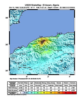
The 1980 El Asnam earthquake occurred on October 10 at 13:25:23 local time with a moment magnitude of 7.1 and a maximum Mercalli intensity of X (Extreme). The shock occurred in the Algerian town of El Asnam. The shocks were felt over 550 km (340 mi) away, with the initial earthquake lasting 35 seconds. It was the largest earthquake in Algeria, and was followed three hours later by a magnitude 6.2 aftershock. The earthquake created about 42 km (26 mi) of surface rupture and had a vertical slip of up to 4.2 m (14 ft). No foreshocks were recorded. The earthquake was found to have occurred very close to the epicenter of the 1954 Chlef earthquake using joint epicenter determination techniques. It occurred at a previously unknown reverse fault.
The 1703 Apennine earthquakes were a sequence of three earthquakes of magnitude ≥6 that occurred in the central Apennines of Italy, over a period of 19 days. The epicenters were near Norcia, Montereale and L'Aquila, showing a southwards progression over about 36 kilometres (22 mi). These events involved all of the known active faults between Norcia and L'Aquila. A total of about 10,000 people are estimated to have died as a result of these earthquakes, although because of the overlap in areas affected by the three events, casualty numbers remain highly uncertain.
The 1783 Calabrian earthquakes were a sequence of five strong earthquakes that hit the region of Calabria in southern Italy, the first two of which produced significant tsunamis. The epicenters form a clear alignment extending nearly 100 km from the Straits of Messina to about 18 km SSW of Catanzaro. The epicenter of the first earthquake occurred in the plain of Palmi. The earthquakes occurred over a period of nearly two months, all with estimated magnitudes of 5.9 or greater. Estimates of the total number of deaths lie in the range 32,000 to 50,000.
The 1694 Irpinia–Basilicata earthquake occurred on 8 September. It caused widespread damage in the Basilicata and Apulia regions of what was then the Kingdom of Naples, resulting in more than 6,000 casualties. The earthquake occurred at 11:40 UTC and lasted between 30 and 60 seconds.

The 1916 Irondale earthquake struck in the north-central region of the U.S. state of Alabama on October 18. The strongest earthquake in state history, it registered an estimated Richter scale magnitude of 5.1 and resulted in minor damage. Damage was limited to Shelby and Jefferson counties and reached its maximum severity near the epicenter in the city of Irondale, including cracked windows, fallen chimneys, and dried-up wells. While there were no fatalities, the earthquake spawned widespread panic, prompting alarmed workers to evacuate tall buildings.
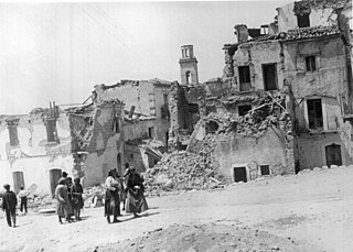
The 1930 Irpinia earthquake occurred at 00:08 UTC on 23 July, chiefly in an area known as Irpinia. It had a surface-wave magnitude of 6.6 and a maximum intensity of X . The event caused 1,404 deaths and 4,624–7,000 injuries. The epicenter was near the boundaries between the regions of Basilicata, Apulia, and Campania.
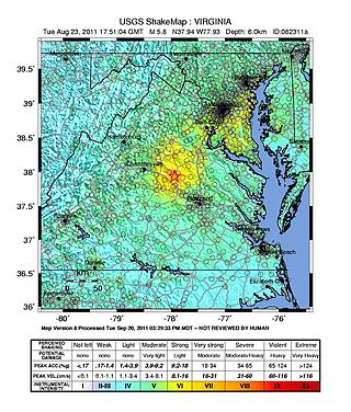
On August 23, 2011, a magnitude 5.8 earthquake hit the Piedmont region of the U.S. state of Virginia at 1:51:04 p.m. EDT. The epicenter, in Louisa County, was 38 mi (61 km) northwest of Richmond and 5 mi (8 km) south-southwest of the town of Mineral. It was an intraplate earthquake with a maximum perceived intensity of VIII (Severe) on the Mercalli intensity scale. Several aftershocks, ranging up to 4.5 Mw in magnitude, occurred after the main tremor.

A series of major earthquakes struck Central Italy between the Marche and Umbria regions in October 2016. The third quake on 30 October was the largest in Italy in 36 years, since the 1980 Irpinia earthquake.
The 1732 Irpinia earthquake was a seismic event with a magnitude of 6.6 that affected Irpinia and part of Sannio. It occurred on 29 November 1732 at 8:40 AM local time (UTC+1). The epicenter was located in the Campanian Apennines, in the area of the Ufita Valley, which is part of the modern-day Province of Avellino. Around twenty populated areas were destroyed entirely or in part and tens of others were significantly damaged. The number of deaths was estimated to be 1,940. Damage from the earthquake was classified as "severe", and the number of homes destroyed as classified as "many". The earthquake had a rating on the modified Mercalli intensity scale of X (extreme).

An earthquake measuring 6.6 Mw on the moment magnitude scale struck Iburi Subprefecture in southern Hokkaido, Japan, on 6 September 2018 at 3:08 a.m. JST. The earthquake's epicenter was near Tomakomai and occurred at a depth of 35.0 kilometers (21.7 mi). The Japan Meteorological Agency (JMA) registered a magnitude of 6.7 Mj and a maximum intensity of 7 on the shindo scale. Shaking from the earthquake was felt strongly in Hokkaido and Aomori Prefecture, and shaking was felt as far away as the Kantō region. Long period ground motion (LPGM) during the earthquake reached maximum of class 4 on the JMA LPGM intensity scales. The earthquake disrupted electrical service throughout Hokkaido, leaving 5.3 million residents without power. Forty-one people were confirmed dead and six hundred and ninety-one were injured. The event is officially known as Heisei san-jū-nen Hokkaidō Iburi tōbu jishin.
On December 5, 1456, the largest earthquake to occur on the Italian Peninsula struck the Kingdom of Naples. The earthquake had an estimated moment magnitude of Mw 7.19–7.4, and was centred near the town of Pontelandolfo in the present-day Province of Benevento, southern Italy. Earning a level of XI (Extreme) on the Modified Mercalli intensity scale, the earthquake caused widespread destruction in central and southern Italy. Estimates of the death toll range greatly with as many as 70,000 deaths reported. It was followed by two strong Mw 7.0 and 6.0 earthquakes to the north on December 30. The earthquake sequence is considered the largest in Italian history, and one of the most studied.
The second shock in the 1962 Irpinia earthquake sequence was the largest and most destructive in a series of earthquakes in the southern Apennines. It occurred on 21 August at 18:19 CET, measuring Mw 6.15 and assigned a maximum intensity of IX (Violent). It was preceded by an Mw 5.68 foreshock, and followed by a 5.34 aftershock. The earthquakes resulted in nearly 20 fatalities and significant property losses.