† largest Vrancea event ever occurred ‡ largest seismic losses ever experienced
Related Research Articles
An earthquake is the shaking of the surface of the Earth resulting from a sudden release of energy in the Earth's lithosphere that creates seismic waves. Earthquakes can range in intensity, from those that are so weak that they cannot be felt, to those violent enough to propel objects and people into the air, damage critical infrastructure, and wreak destruction across entire cities. The seismic activity of an area is the frequency, type, and size of earthquakes experienced over a particular time period. The seismicity at a particular location in the Earth is the average rate of seismic energy release per unit volume. The word tremor is also used for non-earthquake seismic rumbling.
A tsunami is a series of waves in a water body caused by the displacement of a large volume of water, generally in an ocean or a large lake. Earthquakes, volcanic eruptions and other underwater explosions above or below water all have the potential to generate a tsunami. Unlike normal ocean waves, which are generated by wind, or tides, which are in turn generated by the gravitational pull of the Moon and the Sun, a tsunami is generated by the displacement of water from a large event.
Earthquakes are caused by movements within the Earth's crust and uppermost mantle. They range from events too weak to be detectable except by sensitive instrumentation, to sudden and violent events lasting many minutes which have caused some of the greatest disasters in human history. Below, earthquakes are listed by period, region or country, year, magnitude, cost, fatalities and number of scientific studies.
The Hawaiian Islands are an archipelago of eight major islands, several atolls, and numerous smaller islets in the North Pacific Ocean, extending some 1,500 miles from the island of Hawaiʻi in the south to northernmost Kure Atoll. Formerly the group was known to Europeans and Americans as the Sandwich Islands, a name that James Cook chose in honor of the 4th Earl of Sandwich, the then First Lord of the Admiralty. Cook came across the islands by chance when crossing the Pacific Ocean on his Third Voyage in 1778, on board HMS Resolution; he was later killed on the islands on a return visit. The contemporary name of the islands, dating from the 1840s, is derived from the name of the largest island, Hawaiʻi Island.
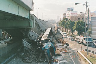
The Great Hanshin Earthquake, or Kobe earthquake, occurred on January 17, 1995, at 05:46:53 JST in the southern part of Hyōgo Prefecture, Japan, including the region known as Hanshin. It measured 6.9 on the moment magnitude scale and had a maximum intensity of 7 on the JMA Seismic Intensity Scale. The tremors lasted for approximately 20 seconds. The focus of the earthquake was located 17 km beneath its epicenter, on the northern end of Awaji Island, 20 km away from the center of the city of Kobe.
The 1964 Alaskan earthquake, also known as the Great Alaskan earthquake and Good Friday earthquake, occurred at 5:36 PM AKST on Good Friday, March 27. Across south-central Alaska, ground fissures, collapsing structures, and tsunamis resulting from the earthquake caused about 131 deaths.
The 1755 Lisbon earthquake, also known as the Great Lisbon earthquake, impacted Portugal, the Iberian Peninsula, and Northwest Africa on the morning of Saturday, 1 November, Feast of All Saints, at around 09:40 local time. In combination with subsequent fires and a tsunami, the earthquake almost completely destroyed Lisbon and adjoining areas. Seismologists estimate the Lisbon earthquake had a magnitude of 7.7 or greater on the moment magnitude scale, with its epicenter in the Atlantic Ocean about 200 km (120 mi) west-southwest of Cape St. Vincent and about 290 km (180 mi) southwest of Lisbon.
The 1960 Valdivia earthquake and tsunami or the Great Chilean earthquake on 22 May 1960 was the most powerful earthquake ever recorded. Various studies have placed it at 9.4–9.6 on the moment magnitude scale. It occurred in the afternoon, and lasted for approximately 10 minutes. The resulting tsunamis affected southern Chile, Hawaii, Japan, the Philippines, eastern New Zealand, southeast Australia, and the Aleutian Islands.
The 2001 Gujarat earthquake, also known as the Bhuj earthquake, occurred on 26 January, India's 52nd Republic Day, at 08:46 am IST. The epicentre was about 9 km south-southwest of the village of Chobari in Bhachau Taluka of Kutch District of Gujarat, India.
An earthquake and a tsunami, known as the Boxing Day Tsunami and, by the scientific community, the Sumatra–Andaman earthquake, occurred at 07:58:53 local time (UTC+7) on 26 December 2004, with an epicentre off the west coast of northern Sumatra, Indonesia. It was an undersea megathrust earthquake that registered a magnitude of 9.1–9.3 Mw, reaching a Mercalli intensity up to IX in certain areas. The earthquake was caused by a rupture along the fault between the Burma Plate and the Indian Plate.
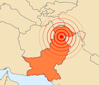
The 2005 Kashmir earthquake occurred at 08:50:39 Pakistan Standard Time on 8 October in Pakistani-administered Azad Kashmir. It was centred near the city of Muzaffarabad, and also affected nearby Balakot in Khyber Pakhtunkhwa and some areas of Indian-administered Jammu and Kashmir. It registered a moment magnitude of 7.6 and had a maximum Mercalli intensity of XI (Extreme). The earthquake was also felt in Afghanistan, Tajikistan, India, and the Xinjiang region. The severity of the damage caused by the earthquake is attributed to severe upthrust. Over 86,000 people died, a similar number were injured, and millions were displaced. It is considered the deadliest earthquake in South Asia, surpassing the 1935 Quetta earthquake.
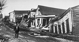
At 05:12 Pacific Standard Time on Wednesday, April 18, 1906, the coast of Northern California was struck by a major earthquake with an estimated moment magnitude of 7.9 and a maximum Mercalli intensity of XI (Extreme). High-intensity shaking was felt from Eureka on the North Coast to the Salinas Valley, an agricultural region to the south of the San Francisco Bay Area. Devastating fires soon broke out in San Francisco and lasted for several days. More than 3,000 people died, and over 80% of the city was destroyed. The events are remembered as one of the worst and deadliest earthquakes in the history of the United States. The death toll remains the greatest loss of life from a natural disaster in California's history and high on the lists of American disasters.
The following is a summary of significant earthquakes during the 21st century. In terms of fatalities, the 2004 Indian Ocean earthquake was the most destructive event with around 227,898 fatalities, followed by the 2010 Haiti earthquake with 160,000 fatalities, 2005 Kashmir earthquake 87,351 fatalities and 2008 Sichuan earthquake with 87,587 fatalities.
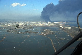
The 2011 Tōhoku earthquake and tsunami occurred at 14:46 JST on 11 March. The magnitude 9.0–9.1 (Mw) undersea megathrust earthquake had an epicenter in the Pacific Ocean, 72 km (45 mi) east of the Oshika Peninsula of the Tōhoku region, and lasted approximately six minutes, causing a tsunami. It is sometimes known in Japan as the "Great East Japan Earthquake", among other names. The disaster is often referred to in both Japanese and English as simply 3.11.
A potent magnitude 6.6 Mw intraplate aftershock occurred at 17:16 JST (08:16 UTC) on 11 April, in the Hamadōri region of Fukushima, Japan. With a shallow focus of 13 km (8.1 mi), the earthquake was centred inland about 36 km (22 mi) west of Iwaki, causing widespread strong to locally severe shaking. It was one of many aftershocks to follow the 11 March Tōhoku earthquake, and the strongest to have its epicentre located inland.
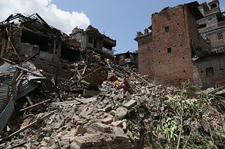
The April 2015 Nepal earthquake killed 8,964 people and injured 21,952 more. It occurred at on Saturday, 25 April 2015, with a magnitude of 7.8Mw or 8.1Ms and a maximum Mercalli Intensity of X (Extreme). Its epicenter was east of Gorkha District at Barpak, Gorkha, roughly 85 km (53 mi) northwest of central Kathmandu, and its hypocenter was at a depth of approximately 8.2 km (5.1 mi). It was the worst natural disaster to strike Nepal since the 1934 Nepal–Bihar earthquake. The ground motion recorded in Kathmandu, capital of Nepal, was of low frequency, which, along with its occurrence at an hour where many people in rural areas were working outdoors, decreased the loss of property and human lives.
This page is based on this Wikipedia article Text is available under the CC BY-SA 4.0 license; additional terms may apply. Images, videos and audio are available under their respective licenses.