An earthquake – also called a quake, tremor, or temblor – is the shaking of the Earth's surface resulting from a sudden release of energy in the lithosphere that creates seismic waves. Earthquakes can range in intensity, from those so weak they cannot be felt, to those violent enough to propel objects and people into the air, damage critical infrastructure, and wreak destruction across entire cities. The seismic activity of an area is the frequency, type, and size of earthquakes experienced over a particular time. The seismicity at a particular location in the Earth is the average rate of seismic energy release per unit volume.
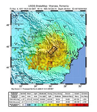
The 1977 Vrancea earthquake occurred on 4 March 1977, at 21:22 local time, and was felt throughout the Balkans. It had a magnitude of 7.5, making it the second most powerful earthquake recorded in Romania in the 20th century, after the 10 November 1940 seismic event. The hypocenter was situated in the Vrancea Mountains, the most seismically active part of Romania, at a depth of 85.3 km.

The Fukuoka earthquake, also known as the Fukuoka Prefecture West Sea Earthquake, struck Fukuoka Prefecture, Japan at 10:53 am JST on March 20, 2005, off the northwest coast of Fukuoka Prefecture, and lasted for approximately 1 minute. The Japan Meteorological Agency (JMA) measured it as peaking at a magnitude of 7.0 and a maximum seismic intensity of less than six, whereas the United States Geological Survey (USGS) reported a magnitude of 6.6. The quake occurred along a previously unknown fault in the Genkai Sea, North of Fukuoka city, and the residents of Genkai Island were forced to evacuate as houses collapsed and multiple landslides occurred in various places. Investigations subsequent to the earthquake determined that the new fault was most likely an extension of the known Kego fault that runs through the centre of the city.
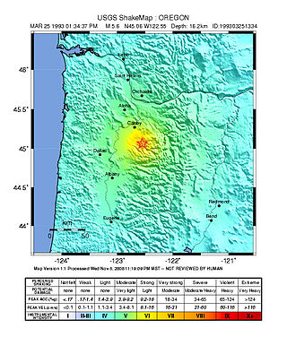
The 1993 Scotts Mills earthquake, also known as the "Spring break quake", occurred in the U.S. state of Oregon on March 25 at 5:34 AM Pacific Standard Time. With a moment magnitude of 5.6 and a maximum perceived intensity of VII on the Mercalli intensity scale, it was the largest earthquake in the Pacific Northwest since the Elk Lake and Goat Rocks earthquakes of 1981. Ground motion was widely felt in Oregon's Willamette Valley, the Portland metropolitan area, and as far north as the Puget Sound area near Seattle, Washington.

In the early morning hours of August 16, 1931, a powerful earthquake occurred in West Texas with a maximum Mercalli intensity of VIII (Severe). Estimates of its magnitude range between 5.8 and 6.4 mb, making it the most powerful earthquake ever recorded in Texas history. Its epicenter was near the town of Valentine, Texas; there, the earthquake caused damage to many homes and buildings. The earthquake may have been caused by movement along oblique-slip faulting in West Texas, the most seismically-active region in the state. Shaking from the earthquake was perceptible within a 400 mi (640 km) radius of the epicenter, affecting four U.S. states and northern Mexico. Several foreshocks and aftershocks accompanied the primary temblor, with the aftershocks continuing until at least November 3, 1931. The main earthquake caused no fatalities, though several people sustained minor injuries; the damage in Valentine amounted to $50,000–$75,000.
The 1940 Vrancea earthquake, also known as the 1940 Bucharest earthquake, occurred on Sunday, 10 November 1940, in Romania, at 03:39, when the majority of the population was at home.
The 1948 Desert Hot Springs earthquake occurred on December 4 at 3:43 p.m. Pacific Standard Time with a moment magnitude of 6.4 and a maximum Mercalli intensity of VII. The shock was felt from the central coast of California in the north, and to Baja California in the south, and came at a time when earthquake research in southern California resumed following the Second World War. It was one of two events in the 20th century that have occurred near a complex region of the southern San Andreas Fault system where it traverses the San Gorgonio Pass and the northern Coachella Valley. Damage was not severe, but some serious injuries occurred, and aftershocks continued until 1957.
The 1802 Vrancea earthquake occurred in the Vrancea Mountains of today's Romania on 26 October [O.S. 14 October] 1802, on St. Paraskeva's Day. With an estimated intensity of 7.9 on the moment magnitude scale, it is the strongest earthquake ever recorded in Romania and one of the strongest in European history. It was felt across an area of more than two million square kilometers in Eastern Europe and the Balkans, from Saint Petersburg to the Aegean Sea.
The 2011 Guerrero earthquake struck with a moment magnitude of 5.7 in southern Mexico at on 5 May. It was positioned west of Ometepec, Guerrero, with a focal depth of 24 km (14.9 mi), and was lightly felt in many adjacent areas.
The 1838 Vrancea earthquake struck the western part of Vrancea County on 23 January with a magnitude of 7.5. The seism caused extensive damage in Moldavia and Wallachia, and killed dozens of people. The earthquake occurred just 36 years after another earthquake of magnitude over 7 on Richter scale devastated the southern part of Wallachia.

The 1990 Vrancea earthquakes were three earthquakes on 30 and 31 May 1990 with magnitudes of 7.0 and 6.2 Mw that struck the Romanian county of Vrancea, on two consecutive days. Severe damage in the Bucharest-Brăila-Brașov area was reported and dozens of casualties in Romania and neighbouring Moldova, Ukraine and Bulgaria.
The 1901 Black Sea earthquakewas a 7.2 magnitude earthquake, the most powerful earthquake ever recorded in the Black Sea. The earthquake epicenter was located in the east of Cape Kaliakra, 30 kilometres (19 mi) off northeast coast of Bulgaria. The mainshock occurred at a depth of 15 km (9.3 mi) and generated a 4–5-metre (13–16 ft) high tsunami that devastated the coastal areas of Romania and Bulgaria. In Romania, the earthquake was felt not only throughout Northern Dobruja, but also in Oltenia and Muntenia, and even in southern Moldova.
The 1738 Vrancea earthquake occurred on 11 June [O.S. 31 May] 1738, during the third rule of Constantin Mavrocordat. The seism aroused great panic and is mentioned in several sources. It occurred in the lower lithospheric block, at a depth of 130 km (81 mi). Its effects were violent on large areas, the hardest hit being Bucharest, where several houses and churches collapsed.

The 2014 Vrancea earthquake struck Vrancea County on 22 November 2014 at , with a moment magnitude of 5.7. The earthquake occurred at a depth of 39 kilometers and lasted for thirty seconds. On the Mercalli scale the quake registered an intensity of VI (Strong).
The 1942 Ecuador earthquake or the Guayaquil earthquake occurred on 13 May at 21:13 local time with a moment magnitude of Mw 7.9. The temblor struck the coastal (Esmeraldas) region of Manabí Province, Ecuador. It caused damage mainly to cities including Guayaquil, Portoviejo and Guaranda. More than 300 people were killed and the total cost of damage was about US$2.5 million. Ecuador's largest city Guayaquil was the most affected despite the significant distantce from the epicenter. Many reinforced concrete structures in a particular area in the city were completely destroyed, contributing to fatalities.
On April 13, 1923 at 15:31 UTC, an earthquake occurred off the northern coast of the Kamchatka Peninsula in the USSR, present-day Russia. The earthquake had a surface-wave magnitude (Ms ) of 6.8–7.3 and an estimated moment magnitude (Mw ) of 7.0–8.2. This event came just two months after a slightly larger earthquake with an epicenter struck south of the April event. Both earthquakes were tsunamigenic although the latter generated wave heights far exceeding that of the one in February. After two foreshocks of "moderate force", the main event caused considerable damage. Most of the 36 casualties were the result of the tsunami inundation rather than the earthquake.
The 1995 Menglian earthquake or 1995 Myanmar–China earthquake occurred on 12 July at 05:46:43 local time in the Myanmar–China border region. The earthquake had an epicenter on the Myanmar side of the border, located in the mountainous region of Shan State. It registered 7.3 on the Chinese surface wave magnitude scale (Ms ) and 6.8 on the moment magnitude scale (Mw ). With a maximum Mercalli intensity assigned at VIII, it killed 11 people and left another 136 injured. Over 100,000 homes in both countries were destroyed and 42,000 seriously damaged. Some damage to structures were also reported in Chiang Mai and Chiang Rai, Thailand. The low death toll from this earthquake was attributed to an early warning issued prior to it happening. Precursor events including foreshocks and some seismic anomalies led to an evacuation of the area before the mainshock struck. It is thought to be one of the few successfully predicted earthquakes in history.
The 1979 Saint Elias earthquake affected Alaska at 12:27 AKST on 28 February. The thrust-faulting Mw 7.4–7.6 earthquake had an epicenter in the Granite Mountains. Though the maximum recorded Modified Mercalli intensity was VII, damage was minimal and there were no casualties due to the remoteness of the faulting. The epicenter lies near the Alaskan border between the United States and Canada.
The 1983 Kaoiki earthquake struck southern Hawaii Island on the morning of November 16, 1983. Measuring Mw 6.7, it was the largest to hit the island since 1975. The epicenter was located 50 km (30 mi) southeast of Hilo with an approximated depth of 12 km (7 mi). The shallow strike-slip earthquake was assigned a maximum intensity of IX (Violent) on the Modified Mercalli scale. 6 people were injured, widespread damage and landslides were reported across the island.