
The Netherlands, informally Holland, is a country located in Northwestern Europe with overseas territories in the Caribbean. It is the largest of four constituent countries of the Kingdom of the Netherlands. The Netherlands consists of twelve provinces; it borders Germany to the east, Belgium to the south, with a North Sea coastline to the north and west. It shares maritime borders with the United Kingdom, Germany and Belgium in the North Sea. The country's official language is Dutch, with West Frisian as a secondary official language in the province of Friesland. Dutch Low Saxon and Limburgish are recognised regional languages, while Dutch Sign Language, Sinte Romani and Yiddish are recognised non-territorial languages. Dutch, English and Papiamento are official in the Caribbean territories.

South Holland is a province of the Netherlands with a population of over 3.7 million as of October 2021 and a population density of about 1,373/km2 (3,560/sq mi), making it the country's most populous province and one of the world's most densely populated areas. Situated on the North Sea in the west of the Netherlands, South Holland covers an area of 3,307 km2 (1,277 sq mi), of which 607 km2 (234 sq mi) is water. It borders North Holland to the north, Utrecht and Gelderland to the east, and North Brabant and Zeeland to the south. The provincial capital is the Dutch seat of government The Hague, while its largest city is Rotterdam. The Rhine-Meuse-Scheldt delta drains through South Holland into the North Sea. Europe's busiest seaport, the Port of Rotterdam, is located in South Holland.
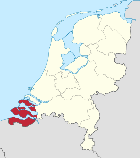
Zeeland is the westernmost and least populous province of the Netherlands. The province, located in the south-west of the country, borders North Brabant to the east, South Holland to the north, and the country of Belgium to the south and west. It consists of a number of islands and peninsulas and a strip bordering the Flemish provinces of East and West Flanders. Its capital is Middelburg with a population of 48,544 as of November 2019, the largest municipality in Zeeland is Terneuzen. Zeeland has two seaports: Vlissingen and Terneuzen. Its area is 2,934 square kilometres (1,130 sq mi), of which 1,151 square kilometres (440 sq mi) is water, and it has a population of 383,689 as of November 2019.

The Reformed Political Party is a conservative Calvinist political party in the Netherlands. The term Reformed is not a reference to political reform but is a synonym for Calvinism—a major branch of Protestantism. The SGP is the oldest political party in the Netherlands existing in its present form, and has been in opposition for its entire existence. Since 1925, it has won between 1.6% and 2.5% of the votes in general elections. Owing to its orthodox political ideals and its traditional role in the opposition, the party has been called a testimonial party. Since the general election of 2012, it has held 3 of the 150 seats of the House of Representatives.
The Delta Works is a series of construction projects in the southwest of the Netherlands to protect a large area of land around the Rhine–Meuse–Scheldt delta from the sea. Constructed between 1954 and 1997, the works consist of dams, sluices, locks, dykes, levees, and storm surge barriers located in the provinces of South Holland and Zeeland.

The Eastern Scheldt is a former estuary in the province of Zeeland, Netherlands, between Schouwen-Duiveland and Tholen on the north and Noord-Beveland and Zuid-Beveland on the south. It also features the largest national park in the Netherlands, founded in 2002.

The Ems is a river in northwestern Germany. It runs through the states of North Rhine-Westphalia and Lower Saxony, and discharges into the Dollart Bay which is part of the Wadden Sea. Its total length is 362.4 kilometres (225.2 mi). The state border between the Lower Saxon area of East Friesland (Germany) and the province of Groningen (Netherlands), whose exact course was the subject of a border dispute between Germany and the Netherlands, runs through the Ems estuary.

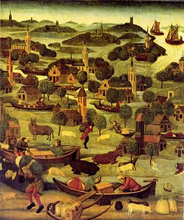
The 1953 North Sea flood was a major flood caused by a heavy storm at the end of Saturday, 31 January 1953 and morning of the next day. The storm surge struck the Netherlands, north-west Belgium, England and Scotland.

Zeelandic is a group of Friso-Franconian language varieties spoken in the southwestern parts of the Netherlands. It is currently considered a Low Franconian dialect of Dutch, but there have been movements to promote the status of Zeelandic from a dialect of Dutch to a separate regional language, which have been denied by the Dutch Ministry of Internal Affairs. More specifically, it is spoken in the southernmost part of South Holland (Goeree-Overflakkee) and large parts of the province of Zeeland, with the notable exception of eastern Zeelandic Flanders.

The All Saints' Flood of 1570 was a disaster which happened on November 1, on the Dutch and German coast. Affected cities include Egmond, Bergen op Zoom and Saeftinghe.
The St. Elizabeth's flood of 1421 was a flooding of the Grote Hollandse Waard, an area in what is now the Netherlands. It takes its name from the feast day of Saint Elisabeth of Hungary which was formerly 19 November. It ranks 20th on the list of worst floods in history. During the night of 18/19 November 1421 a heavy storm near the North Sea coast caused the dikes to break in a number of places and the lower-lying polder land was flooded. A number of villages were swallowed by the flood and were lost, causing between 2,000 and 10,000 casualties. The dike breaks and floods caused widespread devastation in Zeeland and Holland.

Numansdorp is a town and former municipality in the province South Holland in the Netherlands and is located on the island Hoeksche Waard near the Hollands Diep. On 1 January 1984, the municipalities Numansdorp and Klaaswaal were merged into one municipality called Cromstrijen. Cromstrijen was merged into the new municipality Hoeksche Waard in January 2019.

The Dollart or Dollard is a bay in the Wadden Sea between the northern Netherlands and Germany, on the west side of the estuary of the Ems river. Most of it dries at low tide. Many water birds feed there.

The St. Felix's flood happened on Saturday, 5 November 1530, the name day of St. Felix. This day was later known as Evil Saturday (kwade zaterdag). Large parts of Flanders and Zeeland were washed away, including the Verdronken Land van Reimerswaal. According to Audrey M. Lambert, "all the Oost Wetering of Zuid-Beveland was lost, save only the town of Reimerswaal."

Het Verdronken Land van Reimerswaal is an area of flood-covered land in Zeeland in the Netherlands between Noord Beveland and Bergen op Zoom. Some of it was lost in the St. Felix's Flood in 1530, and some of it in 1532. The Oosterschelde formerly flowed along its east and north edges. It is sometimes divided into the "Verdronken Land van Zuid-Beveland" and the "Verdronken Land van de Markiezaat van Bergen op Zoom". Verdronken is Dutch for "drowned", and Markizaat van Bergen op Zoom is the marquisate of Bergen op Zoom).

Paal is a hamlet in the southwest Netherlands. It is a part of the municipality of Hulst, Zeeland, and is located 35 km north of Antwerp, Belgium.

Brabantine Gothic, occasionally called Brabantian Gothic, is a significant variant of Gothic architecture that is typical for the Low Countries. It surfaced in the first half of the 14th century at St. Rumbold's Cathedral in the City of Mechelen.
Hendrik Peter "Henk" Jonker was a Dutch photographer. During World War II, he documented the impact of the German occupation of the Netherlands and after the war he started a press agency. Praised for portraying "ordinary people and small moments", his work appeared internationally in publications such as Time and Der Spiegel and was included in the 1955 exhibition The Family of Man; particularly notable are his photographs taken during the North Sea Flood of 1953.
Lydia Schouten is an internationally-known Dutch performance and video artist. Early in her career she critiqued traditional women's roles and the portrayal of women as sex objects. More recently, her work considers themes of loneliness, sex and violence. As of 2004, she lives in Amsterdam. Her work has been exhibited internationally and she has held artist in residencies in several countries. Schouten received the Maaskant Award from city of Rotterdam in 1975.

Provincial elections were held in the Netherlands on 20 March 2019. Eligible voters elected the members of the Provincial States in the twelve provinces of the Netherlands. The elections were held on the same day as the 2019 Dutch water boards elections and, in the Caribbean Netherlands, island council elections.
