
Bommenede or Bommenee is a former island, village, and municipality in the Netherlands, located about 5 km east of the city of Brouwershaven.
Bommenede or Bommenee is a former island, village, and municipality in the Netherlands, located about 5 km east of the city of Brouwershaven.
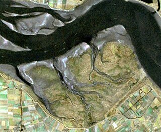
Bommenede was founded in the early 12th century by monks of the Cistercian monastery of Ter Duinen in Flanders. It was located on one of the four islands that later joined up to form the current island of Schouwen-Duiveland. The name was first mentioned in 1165, as insula Bomne. The island was a part of Holland, because the boundary between Holland and Zeeland lay in the Sonnemere, the water south of Bommenede.
According to the 19th-century historian A.J. van der Aa, [1] John of Bavaria ordered the construction of dykes around the island in 1412, creating the polder of Bommenede. The village of Bommenede was listed in 1153 as property of the Cistercian monastery of Ter Duinen in Flanders. The village survived two floods in 1530 and 1532 and a fire in 1540. In 1570, Bommenede and the neighbouring polder "Kijkuit" were flooded during the All Saints' Flood.

Because of the strategic location of the village, a defensive wall was built around it in 1574. The following year, the Spanish commander Mondragon besieged it for 20 days, and shot the village to pieces. At the end of the siege, no more than 20 healthy men survived in the village. [1]
The village was flooded again on January 26, 1682. The destruction was so great, that the Estates of Holland decided not to rebuild the village, and the last inhabitants left in 1684. Some remains of the village (now sometimes referred to as Oud-Bommenede) remained visible for years. Nowadays, there is still some overgrown debris in the waters of the Grevelingen.
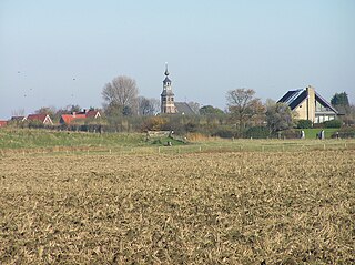
Part of the former island was reclaimed from the sea in 1701. In the southern part of the new polder, a new hamlet grew: Nieuw-Bommenede. In the middle of the 19th century, it had about 410 inhabitants. [1]

Bommenede was a separate heerlijkheid , and later a separate municipality (also called "Bommenede en Bloois"), until it was merged with the municipality of Zonnemaire on January 4, 1866. [2]

Holland is a geographical region and former province on the western coast of the Netherlands. From the 10th to the 16th century, Holland proper was a unified political region within the Holy Roman Empire as a county ruled by the counts of Holland. By the 17th century, the province of Holland had risen to become a maritime and economic power, dominating the other provinces of the newly independent Dutch Republic.

Koksijde is a town and a municipality in Belgium. It is located on the North Sea coast in the southwest of the Flemish province of West Flanders.

Beveren is a municipality in the Belgian province of East Flanders which comprises the towns of Beveren, Doel, Haasdonk, Kallo, Kieldrecht, Melsele, Verrebroek and Vrasene.
Saeftinghe or Saaftinge was a town in the southwest Netherlands, located in eastern Zeelandic Flanders, near Nieuw-Namen. It existed until 1584. It is now a swamp known as the Drowned Land of Saeftinghe and an official nature reserve area. The land is a crosspoint where the river Scheldt meets the salty waters of the North Sea in the estuary Western Scheldt. It is a treacherous place where the tides easily consume large stretches of land in a matter of seconds and must not be explored without an experienced guide.

Numansdorp is a village and former municipality in the province South Holland in the Netherlands and is located on the island Hoeksche Waard near the Hollands Diep. On 1 January 1984, the municipalities Numansdorp and Klaaswaal were merged into one municipality called Cromstrijen. Cromstrijen was merged into the new municipality Hoeksche Waard in January 2019.

Kruiningen is a village in the Dutch province of Zeeland. It is located in the municipality of Reimerswaal, about 5 km south of the village of Yerseke.

Noordgouwe is a village in the Dutch province of Zeeland. It is a part of the municipality of Schouwen-Duiveland, and lies about 5 km north of Zierikzee.

Oosterland is a village in the south-west Netherlands. It is located in the municipality of Schouwen-Duiveland, Zeeland, about 22 km south of Hellevoetsluis.

Dussen is a village in the Dutch province of North Brabant. It is a part of the municipality of Altena, and is located about 12 km south of Gorinchem. Dussen Castle is located near the village.

Termunten is a village in the Dutch province of Groningen. It is a part of the municipality of Eemsdelta, and lies about 33 km east of Groningen.
Lamswaarde is a village in the Dutch province of Zeeland. It is a part of the municipality of Hulst, and lies about 23 km southwest of Bergen op Zoom.

Ossenisse is a village in the Dutch province of Zeeland. It is a part of the municipality of Hulst, and lies about 24 km west of Bergen op Zoom.
Kattendijke is a village in the Dutch province of Zeeland. It is located in the municipality of Goes on the Oosterschelde about 5 km northeast of the city of Goes.

Klaaskinderenkerke is a former village in the Dutch province of Zeeland. The polder Klaaskinderen was flooded on December 14, 1511, and was never reclaimed again. The church of Klaaskinderenkerke disappeared in this flood, and in the 19th century, only a small hamlet was left.
Koedood is a hamlet in the Dutch province of South Holland. It is located on the border of the municipalities of Albrandswaard and Barendrecht.

Maasdam is a village in the Dutch province of South Holland. It is located about 14 km south of the city of Rotterdam, in the municipality of Hoeksche Waard, on the rural Hoeksche Waard island.
Onwaard is a former municipality in the Dutch province of South Holland. It was located east of the village of Melissant on the island Goeree-Overflakkee. The municipality contained no villages nor hamlets; only a few farms. It consisted of a number of small polders: Onwaard, Oud-Kraaijer, Kraaijenisse, and part of the Nieuw-Kraaijer polder.
De Vennip is a former municipality in the Dutch province of North Holland. It consisted of a small area of land east of Hillegom, and a large part of the Haarlemmermeer lake, including the island of Beinsdorp.

Ter Doest Abbey was a Cistercian abbey in Belgium, in the present Lissewege, a district of Bruges, West Flanders.

Ten Duinen Abbey or the Abbey of the Dunes was a Cistercian monastery at Koksijde in what is now Belgium. It was one of the richest and most influential religious institutions in the medieval County of Flanders. It later relocated to the city of Bruges.