

This is an alphabetically arranged list of trading posts or forts in present-day Montana from 1807 to the end of the fur trading era in the state.
This is an alphabetically arranged list of trading posts or forts in present-day Montana from 1807 to the end of the fur trading era in the state.
The North West Company fur trader Francois-Antoine Larocque travelled parts of the eastern present-day Montana in 1805, [1] : 156–220 and the following explorations of the Lewis and Clark Expedition opened the area further for commerce. [1] : 28 The first fur trading post built in the future state was Fort Raymond at the confluence of Yellowstone River and Bighorn River, where it carried out trade with the Crow Nation from 1807 to around 1813. [2] : 68 Soon after the establishment of Fort Raymond, trail-blazers from the fur companies found way to the heart of the country of every Native Nation in the territory. Decade by decade, at number of smaller and bigger posts established by different trading companies from both Canada and the United States dotted the banks of the major rivers winding their way through the plains and mountain valleys. The biggest forts stayed active year after year, while others lasted a season and were destroyed by wind and weather or burned by Native Americans. Some of the ruins and old places of bargain are now recognized as historic sites by the United States or Montana. [3]
| Name | Other names | Location | County | Company | Active | Main customers | Remarks |
|---|---|---|---|---|---|---|---|
| Big Horn Post#2 [3] : 127 | Confluence of the Bighorn and the Yellowstone | Treasure | Rocky Mountain Fur Company | 1824– ? | The Crow | ||
| Brazeau Houses [3] : 110 | Braseau's Houses | Extreme lower Yellowstone | Richland | 1828– ? | |||
| Fort Alexander [3] : 114 | North side of the Yellowstone, six miles west of Forsyth | Rosebud | American Fur Company | 1842–1850 [2] : 67 | The Crow | ||
| Fort Andrew [3] : 98 | At the Missouri, 30 miles east of James Kipp Recreation Area | Phillips | American Fur Company | 1862– ? | Inundated | ||
| Fort Benton (#1) [3] : 127 | At the confluence of the Bighorn and the Yellowstone | Treasure | Missouri Fur Company | 1821– 1824? [2] : 68 | The Crow | ||
| Fort Benton [3] : 35 | Fort Lewis, Fort Clay | At the Upper Missouri, city of Fort Benton | Chouteau | American Fur Company | 1846–1864 | The Blackfeet | National Historic Landmark |
| Fort Campbell [3] : 36 | Near the city of Fort Benton | Chouteau | Harvey, Primeau & Co. | 1846–1861 | |||
| Fort Cass [3] : 127 | At the confluence of the Bighorn and the Yellowstone | Treasure | American Fur Company | 1832–1838 [2] : 68 | The Crow | ||
| Fort Chardon [4] : 46 | Fort F. A. Chardon | At the confluence of the Judith and the Missouri | Chouteau | 1843– ? | |||
| Fort Charles [3] : 129 | At the Missouri, right east of Oswego | Valley | 1861– ? | ||||
| Fort Connah [3] : 72 | Near Post Creek | Lake | Hudson's Bay Company | 1845–1871 | |||
| Fort Cotton [3] : 36 | At the upper Missouri, 10 miles southwest of Fort Benton | Chouteau | Union Fur Company | 1843– ? (short-lived) | |||
| Fort Dauphin [3] : 129 | At the Missouri, south of Nashua | Valley | Louis Dauphin | 1860– ? | |||
| Fort Galpin [3] : 129 | At the Missouri, near the city of Fort Peck | Valley | LaBarge, Harkness and Company | 1862–1864 | |||
| Fort Hawley [3] : 98 | At the Missouri, 30 miles east of James Kipp Recreation Area | Phillips | Northwest Fur Company | 1866– ? | Inundated | ||
| Fort Jackson [3] : 111 | At the Missouri, near Poplar | Roosevelt | American Fur Company | 1833– ? (short-lived) | |||
| Fort Kipp [3] : 98 | At the Missouri, near the city of Fort Kipp | Roosevelt | 1860-1860 | Burned by Native Americans | |||
| Fort LaBarge [3] : 36 | At the Missouri, near the city of Fort Benton | Chouteau | LaBarge, Harkness and Company | 1862– ? | |||
| Fort Lewis [3] : 36 | At the Missouri, west of the city of Fort Benton | Chouteau | American Fur Company | ? – 1847 | Dismantled and rebuilt as part of Fort Benton | ||
| Fort McKenzie [3] : 36 | Fort Brulé [5] : 962 | At the Missouri, east of the city of Fort Benton | Chouteau | American Fur Company | 1832–1843 | The Blackfeet | Burned by Native Americans [5] : 962 |
| Fort Owen [3] : 107 | Bitterroot Valley, east of Stevensville | Ravalli | Major John Owen | 1850–1872 | The Bitterroot Salish | Now a state park | |
| Fort Piegan [3] : 37 | At the confluence of the Marias and the Missouri | Chouteau | 1831–1832 | The Blackfeet | Burned by Native Americans [5] : 961 | ||
| Fort Poplar [3] : 111 | At the Missouri, near Poplar | Roosevelt | A Charles Larpenteur post | 1861– ? | |||
| Fort Raymond [3] : 127 | Fort Remon, Fort Lisa, Fort Manuel Lisa, Big Horn Post | At the confluence of the Yellowstone and the Bighorn | Treasure | Missouri Fur Company [1] : 31 | 1807–1813(?) [2] : 68 | The Crow | |
| Fort Sarpy I [3] : 114 | On the north side of the Yellowstone, 10 miles east of Forsyth | Rosebud | American Fur Company | 1850–1856 [6] | The Crow | ||
| Fort Sarpy II [3] : 127 | At the Yellowstone, 10 miles east of the mouth of the Bighorn | Treasure | American Fur Company | 1857– c. 1860 [2] : 67–68 | The Crow | ||
| Fort Stewart [3] : 111 | At the Missouri, near the City of Fort Kipp | Roosevelt | Frost, Todd and Company | 1854–1860 | Burned by Native Americans | ||
| Fort Union [3] : 111 | At the Missouri, right east of the Montana – North Dakota border | Right east of Roosevelt | American Fur Company | 1828–1867 [7] : 15 | The Assiniboine and Cree | National Park Service Area | |
| Fort Van Buren [3] : 114 | Fort Tulloch, Fort Tullock and Tulloch's Fort [5] : 965 | At the Yellowstone, 10 miles east of Forsyth | Rosebud | American Fur Company | 1835–1842 [2] : 68 | The Crow | |
| Fox, Livingston and Company Post [3] : 19 | At the confluence of the Little Bighorn and the Bighorn [5] : 965 | Big Horn | Fox, Livingston and Company | 1843– ? | The Crow | (Only [3] : 19 has a trading post of this name here) | |
| Henry's Fort [3] : 57 | Three Forks Post | A mile east of Three Forks | Gallatin | Missouri Fur Company | 1810– ? | ||
| Howse's Post [3] : 52 | Howse House | North of Kalispell | Flathead | Hudson's Bay Company | 1810– ? | The Pend d'Oreilles and Salish | |
| Kootenai Post I [3] : 80 | At Kootenai River, near Libby | Lincoln | North West Fur Company | 1808– ? | The tribes at the upper Columbia | ||
| Kootenai Post II [4] : 49 | Near Libby Dam | Lincoln | 1811– ? | ||||
| Salish House I [3] : 117 | Saleesh House, Flathead Post | Near Thompson Falls | Sanders | North West Fur Company [4] : 49 | 1809– ? | ||
| Salish House II [3] : 117 | Ten miles east of Thompson Falls | Sanders | Hudson's Bay Company | 1824– ? | |||


The Missouri River is a river in the Central and Mountain West regions of the United States. The nation's longest, it rises in the eastern Centennial Mountains of the Bitterroot Range of the Rocky Mountains of southwestern Montana, then flows east and south for 2,341 miles (3,767 km) before entering the Mississippi River north of St. Louis, Missouri. The river drains semi-arid watershed of more than 500,000 square miles (1,300,000 km2), which includes parts of ten U.S. states and two Canadian provinces. Although a tributary of the Mississippi, the Missouri River is slightly longer and carries a comparable volume of water. When combined with the lower Mississippi River, it forms the world's fourth-longest river system.

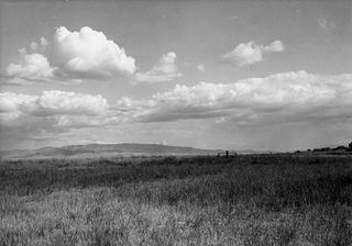
Montana is a landlocked state in the Mountain West subregion of the Western United States. It borders Idaho to the west, North Dakota to the east, South Dakota to the southeast, Wyoming to the south, and the Canadian provinces of Alberta, British Columbia, and Saskatchewan to the north. It is the fourth-largest state by area, the eighth-least populous state, and the third-least densely populated state. Its capital is Helena, while the most populous city is Billings. The western half of the state contains numerous mountain ranges, while the eastern half is characterized by western prairie terrain and badlands, with smaller mountain ranges found throughout the state.

The Crow, whose autonym is Apsáalooke, also spelled Absaroka, are Native Americans living primarily in southern Montana. Today, the Crow people have a federally recognized tribe, the Crow Tribe of Montana, with an Indian reservation, the Crow Indian Reservation, located in the south-central part of the state.

Deer Lodge is a city in and the county seat of Powell County, Montana, United States. The population was 2,938 at the 2020 census.

Jean Baptiste Charbonneau, sometimes known in childhood as Pompey or Little Pomp, was a Lemhi Shoshone-French Canadian explorer, guide, fur trapper, trader, military scout during the Mexican–American War, alcalde (mayor) of Mission San Luis Rey de Francia and a gold digger and hotel operator in Northern California. His mother was Sacagawea, a Shoshone who worked as a guide and interpreter for the Lewis and Clark Expedition. Charbonneau spoke French and English and learned German and Spanish during his six years in Europe from 1823 to 1829. He spoke Shoshone and other western Native American languages, which he picked up during his years of trapping and guiding.

Red Cloud's War was an armed conflict between an alliance of the Lakota, Northern Cheyenne, and Northern Arapaho peoples against the United States and the Crow Nation that took place in the Wyoming and Montana territories from 1866 to 1868. The war was fought over control of the western Powder River Country in present north-central Wyoming.

The Arikara War was a military conflict between the United States and Arikara in 1823 fought in the Great Plains along the Upper Missouri River in the Unorganized Territory. For the United States, the war was the first in which the United States Army was deployed for operations west of the Missouri River on the Great Plains. The war, the first and only conflict between the Arikara and the U.S., came as a response to an Arikara attack on U.S. citizens engaged in the fur trade. The Arikara War was called "the worst disaster in the history of the Western fur trade".
Fort Hall was a fort in the Western United States that was built in 1834 as a fur trading post by Nathaniel Jarvis Wyeth. It was located on the Snake River in the eastern Oregon Country, now part of present-day Bannock County in southeastern Idaho. Wyeth was an inventor and businessman from Boston, Massachusetts, who also founded a post at Fort William, in present-day Portland, Oregon, as part of a plan for a new trading and fisheries company. In 1837, unable to compete with the powerful British Hudson's Bay Company, based at Fort Vancouver, Wyeth sold both posts to it. Great Britain and the United States both operated in the Oregon Country in these years.

The Hidatsa are a Siouan people. They are enrolled in the federally recognized Three Affiliated Tribes of the Fort Berthold Reservation in North Dakota. Their language is related to that of the Crow, and they are sometimes considered a parent tribe to the modern Crow in Montana.
Arikara, also known as Sahnish, Arikaree, Ree, or Hundi, are a tribe of Native Americans in North Dakota. Today, they are enrolled with the Mandan and the Hidatsa as the federally recognized tribe known as the Mandan, Hidatsa, and Arikara Nation.
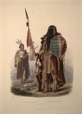
The Assiniboine or Assiniboin people, also known as the Hohe and known by the endonym Nakota, are a First Nations/Native American people originally from the Northern Great Plains of North America.

The Bozeman Trail was an overland route in the Western United States, connecting the gold rush territory of southern Montana to the Oregon Trail in eastern Wyoming. Its most important period was from 1863 to 1868. Despite the fact that the major part of the route in Wyoming used by all Bozeman Trail travelers in 1864 was pioneered by Allen Hurlbut, it was named after John Bozeman. Many miles of the Bozeman Trail in present Montana followed the tracks of Bridger Trail, opened by Jim Bridger in 1864.

Fort Union Trading Post National Historic Site is a partial reconstruction of the most important fur trading post on the upper Missouri River from 1829 to 1867. The fort site is about two miles from the confluence of the Missouri River and its tributary, the Yellowstone River, on the Dakota side of the North Dakota/Montana border, 25 miles from Williston, North Dakota.
This is a broad outline of the history of Montana in the United States.

The Crow Indian Reservation is the homeland of the Crow Tribe. Established 1868, the reservation is located in parts of Big Horn, Yellowstone, and Treasure counties in southern Montana in the United States. The Crow Tribe has an enrolled membership of approximately 11,000, of whom 7,900 reside in the reservation. 20% speak Crow as their first language.
The Iron Confederacy or Iron Confederation was a political and military alliance of Plains Indians of what is now Western Canada and the northern United States. This confederacy included various individual bands that formed political, hunting and military alliances in defense against common enemies. The ethnic groups that made up the Confederacy were the branches of the Cree that moved onto the Great Plains around 1740, the Saulteaux, the Nakoda or Stoney people also called Pwat or Assiniboine, and the Métis and Haudenosaunee. The Confederacy rose to predominance on the northern Plains during the height of the North American fur trade when they operated as middlemen controlling the flow of European goods, particularly guns and ammunition, to other Indigenous nations, and the flow of furs to the Hudson's Bay Company (HBC) and North West Company (NWC) trading posts. Its peoples later also played a major part in the bison (buffalo) hunt, and the pemmican trade. The decline of the fur trade and the collapse of the bison herds sapped the power of the Confederacy after the 1860s, and it could no longer act as a barrier to U.S. and Canadian expansion.
This is a timeline of pre-statehood Montana history comprising substantial events in the history of the area that would become the State of Montana prior to November 8, 1889. This area existed as Montana Territory from May 28, 1864, until November 8, 1889, when it was admitted to the Union as the State of Montana.

The fur trade in Montana was a major period in the area's economic history from about 1800 to the 1850s. It also represents the initial meeting of cultures between indigenous peoples and those of European ancestry. British and Canadian traders approached the area from the north and northeast focusing on trading with the indigenous people, who often did the trapping of beavers and other animals themselves. American traders moved gradually up the Missouri River seeking to beat British and Canadian traders to the profitable Upper Missouri River region.
This timeline of South Dakota is a list of events in the history of South Dakota by year.
Edward Rose was an early American explorer, trapper, guide and interpreter. During his life, Rose alternated between residing with Native American tribes and working on behalf of commercial fur trapping expeditions funded by Eastern companies. His position at the intersection of these cultures made him a sought-after facilitator of communication and exchange of goods.