
Clark County is located in the U.S. state of Nevada. As of the 2020 census, the population was 2,265,461. Most of the county population resides in the Las Vegas Census County Divisions, which hold 1,771,945 people as of the 2010 Census, across 476 square miles (1,233 km2). It is by far the most populous county in Nevada, and the 11th most populous county in the United States. It covers 7% of the state's land area but holds 74% of the state's population, making Nevada one of the most centralized states in the United States.

Nye County is a county in the U.S. state of Nevada. As of the 2010 census, the population was 43,946. Its county seat is Tonopah. At 18,159 square miles (47,030 km2), Nye is Nevada's largest county by area and the third-largest county in the contiguous United States, behind Coconino County of Arizona and San Bernardino County of California.

The Great Basin is the largest area of contiguous endorheic watersheds – those with no outlets – in North America. It spans nearly all of Nevada, much of Utah, and portions of California, Idaho, Oregon, Wyoming, and Baja California, Mexico. It is noted for both its arid climate and the basin and range topography that varies from the North American low point at Badwater Basin in Death Valley to the highest point of the contiguous United States, less than 100 miles (160 km) away at the summit of Mount Whitney. The region spans several physiographic divisions, biomes, ecoregions, and deserts.

The Mojave Desert is a xeric desert in the rain shadow of the Sierra Nevada mountains in the Southwestern United States. It is named for the indigenous Mojave people. It is located primarily in southeastern California and southwestern Nevada, with small portions extending into Arizona and Utah.

The Amargosa River is an intermittent waterway, 185 miles (298 km) long, in southern Nevada and eastern California in the United States. It drains a high desert region, the Amargosa Valley in the Amargosa Desert northwest of Las Vegas, into the Mojave Desert, and finally into Death Valley where it disappears into the ground aquifer. Except for a small portion of its route in the Amargosa Canyon in California and a small portion at Beatty, Nevada, the river flows above ground only after a rare rainstorm washes the region. A 26-mile (42 km) stretch of the river between Shoshone and Dumont Dunes is protected as a National Wild and Scenic River. At the south end of Tecopa Valley the Amargosa River Natural Area protects the habitat.

Amargosa Valley is an unincorporated town located on U.S. Route 95 in Nye County, in the U.S. state of Nevada.
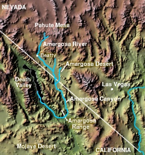
The Amargosa Valley is the valley through which the Amargosa River flows south, in Nye County, southwestern Nevada and Inyo County in the state of California. The south end is alternately called the "Amargosa River Valley'" or the "Tecopa Valley." Its northernmost point is around Beatty, Nevada and southernmost is Tecopa, California, where the Amargosa River enters into the Amargosa Canyon.

The Desert National Wildlife Refuge is a protected wildlife refuge, administered by the U.S. Fish and Wildlife Service, located north of Las Vegas, Nevada, in northwestern Clark and southwestern Lincoln counties, with much of its land area lying within the southeastern section of the Nevada Test and Training Range. The Desert NWR, created on May 20, 1936, is the largest wildlife refuge in the lower 48 states of the United States, encompassing 1.615 million acres (6,540 km2) of the Mojave Desert in the southern part of Nevada. The refuge was originally established at 2.25 million acres. In 1940 840,000 acres were transferred to the Department of Defense.

The Amargosa Desert is located in Nye County in western Nevada, United States, along the California–Nevada border, comprising the northeastern portion of the geographic Amargosa Valley, north of the Ash Meadows National Wildlife Refuge
The Kawich Range is a mountain range in Nye County in southern Nevada in the United States, just south of the Hot Creek Range. The southern part of the range lies on the Nellis Air Force Range. The mountains cover an area of about 250 square miles (650 km2) and contain Kawich Peak, at 9,399 feet (2,865 m) above sea level. U.S. Route 6 crosses the pass between The Kawich and the Hot Creek ranges and meets State Route 375 at Warm Springs just north of the range. To the east lies the Reveille and Kawich valleys with the Reveille Range to the east of the northern portion and the Belted Range east of Quartzite Mountain at the southern end. The broad Pahute Mesa and Gold Flat lie to the south with Cactus Flat and the Cactus Range to the southwest. To the northwest across Stone Cabin Valley lies the Monitor Range.

The Nevada Test and Training Range (NTTR) is one of two military training areas at the Nellis Air Force Base Complex in Nevada and used by the United States Air Force Warfare Center at Nellis Air Force Base. The NTTR land area includes a "simulated Integrated Air Defense System", several individual ranges with 1200 targets, and 4 remote communication sites. The current NTTR area and the range's former areas have been used for aerial gunnery and bombing, for nuclear tests, as a proving ground and flight test area, for aircraft control and warning, and for Blue Flag, Green Flag, and Red Flag exercises.
The Las Vegas–Henderson combined statistical area, known prior to 2013 as the Las Vegas–Paradise–Pahrump combined statistical area, is made up of two counties in southern Nevada and one in northwestern Arizona. The statistical area consists of the Las Vegas–Paradise, NV MSA, the Lake Havasu City–Kingman, AZ MSA and the Pahrump micropolitan statistical area. At the 2010 census, the CSA had a population of 2,195,401.

The Las Vegas Range is an arid mountain range in Clark County, Nevada. The range is located in the southeast of the Desert National Wildlife Refuge.

Three Lakes Valley is a 25-mile (40 km) long, partially endorheic valley in southwest Lincoln County and northwest Clark County, Nevada. The southwest of the valley has a narrowing with washes that flow south into the watershed of the Las Vegas Valley, a tributary to Lake Mead–Colorado River watersheds.

The Pahute Mesa (landform) is a large, 60 miles (97 km) long mesa in southern Nye County, Nevada. The mesa's southeast region lies in the Nevada Test Site which is southeast; the region in the test site is called Pahute Mesa, one of the major test site sub-regions.
Sarcobatus Flat is a closed valley in western Nye County, Nevada between Goldfield and Beatty. The Bullfrog Hills form the southern boundary and the Grapevine Mountains along with Bonnie Claire Flat form the western boundary. Pahute Mesa bounds the area to the east and north. To the north the flat is contiguous with Lida Valley and Stonewall Flat.

Cactus Flat is one of the Central Nevada Desert Basins in the Cactus-Sacrobatus Watershed, for which it is an eponym. The flat is the location of the Tonopah Test Range Airport and Tonopah Test Range, a component of the Nevada Test and Training Range used for weapons testing since the 1950s. The flat is also the site of the 615 sq mi (1,590 km2) Nevada Wild Horse Range of the Nellis Air Force Range.
The Nellis Air Force Base Complex is the southern Nevada military region of federal facilities and lands, e.g., currently and formerly used for military and associated testing and training such as Atomic Energy Commission atmospheric nuclear detonations of the Cold War. The largest land area of the complex is the Nevada Test and Training Range, and numerous Formerly Used Defense Sites remain federal lands of the complex. Most of the facilities are controlled by the United States Air Force and/or the Bureau of Land Management, and many of the controlling units are based at Creech and Nellis Air Force Bases. Initiated by a 1939 military reconnaissance for a bombing range, federal acquisition began in 1940, and McCarren Field became the World War II training area's 1st of 3 Nevada World War II Army Airfields and 10 auxiliary fields. The area's first military unit was initially headquartered in the Las Vegas Federal Building while the WWII Las Vegas Army Airfield buildings were constructed.