
The Sierra Nevada is a mountain range in the Western United States, between the Central Valley of California and the Great Basin. The vast majority of the range lies in the state of California, although the Carson Range spur lies primarily in Nevada. The Sierra Nevada is part of the American Cordillera, an almost continuous chain of mountain ranges that forms the western "backbone" of the Americas.

The Black Rock Desert is a semi-arid region of lava beds and playa, or alkali flats, situated in the Black Rock Desert–High Rock Canyon Emigrant Trails National Conservation Area, a silt playa 100 miles (160 km) north of Reno, Nevada that encompasses more than 300,000 acres (120,000 ha) of land and contains more than 120 miles (200 km) of historic trails. It is in the northern Nevada section of the Great Basin with a lakebed that is a dry remnant of Pleistocene Lake Lahontan.

Mount Ritter is the highest mountain in Madera County, California, in the Western United States, at an elevation of 13,149 feet (4,008 m). It is also the highest and most prominent peak of its namesake, the Ritter Range, a subrange of the Sierra Nevada in the Ansel Adams Wilderness of the Inyo and Sierra National Forests. Mount Ritter is the 15th highest mountain peak in California with at least 500 meters of topographic prominence.
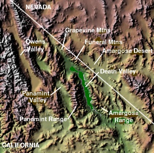
The Grapevine Mountains are a mountain range located along the border of Inyo County, California and Nye County, Nevada in the United States. The mountain range is about 22 miles (35 km) long and lies in a northwest-southeasterly direction along the Nevada-California state line. The range reaches an elevation of 8,738 feet (2,663 m) at Grapevine Peak, near Phinney Canyon on the Nevada side. Daylight Pass is at the southern end of the range. Most of the Grapevine Mountain chain is in Death Valley National Park.
The Grant Range Wilderness is a protected wilderness area in the Grant Range of Nye County, in the central section of the state of Nevada in the western United States.

The Nevada Test and Training Range (NTTR) is one of two military training areas at the Nellis Air Force Base Complex in Nevada and used by the United States Air Force Warfare Center at Nellis Air Force Base. The NTTR land area includes a "simulated Integrated Air Defense System", several individual ranges with 1200 targets, and 4 remote communication sites. The current NTTR area and the range's former areas have been used for aerial gunnery and bombing, for nuclear tests, as a proving ground and flight test area, for aircraft control and warning, and for Blue Flag, Green Flag, and Red Flag exercises.

Freel Peak is a mountain located in the Carson Range, a spur of the Sierra Nevada, near Lake Tahoe in California.

Mount Rose is the highest mountain in Washoe County, within the Carson Range of Nevada, United States. It ranks thirty-seventh among the most topographically prominent peaks in the state. It is also both the highest and most topographically prominent peak of the greater Sierra Nevada range within the state of Nevada, and the third most topographically prominent peak in the Sierra Nevada overall. It is located in the Mount Rose Wilderness of the Humboldt-Toiyabe National Forest. An extinct volcano, the mountain is in between Lake Tahoe and Reno. State Route 431 traverses Mount Rose Summit southeast of Mount Rose. Due to the high elevation, most of the precipitation that falls on the mountain is snow. The view from Mount Rose, facing east is the Truckee Meadows area is the second largest population center in Nevada.

Leavitt Peak is located in the Emigrant Wilderness near Sonora Pass in the eastern Sierra Nevada range of California. Leavitt Peak is located on the Tuolumne County - Mono County line. The Pacific Crest Trail runs close to the east of Leavitt Peak, at an elevation of about 10,800 feet (3,290 m) elevation. The peak offers views south to Yosemite National Park and north towards South Lake Tahoe.
The Seven Troughs Range is a mountain range in western Pershing County, Nevada.
The Desert Range is a mountain range in Clark County, Nevada.
The Antelope Range is a mountain range in Pershing County, Nevada.
The Gabbs Valley Range is a mountain range in the west of the central Nevada desert in the Great Basin region. The range is within Mineral County, Nevada.
The Pine Forest Range is a mountain range in Humboldt County, in the U.S. state of Nevada. It is north of the Black Rock Desert.

The Shoshone Range is a mountain range in Lander County, Nevada. The northeast end of the range extends into Eureka County at Shoshone Point on the Humboldt River.

Three Lakes Valley is a 25-mile (40 km) long, partially endorheic valley in southwest Lincoln County and northwest Clark County, Nevada. The southwest of the valley has a narrowing with washes that flow south into the watershed of the Las Vegas Valley, a tributary to Lake Mead–Colorado River watersheds.

The Carson Desert is a desert in the Lahontan Basin and the desert valley of Churchill County, Nevada (U.S.), which receives an average 5 inches (130 mm) annual precipitation. The desert is the low valley area between the adjacent mountain ranges, while the larger watershed includes the interior slopes of the demarcating ranges. The desert was inundated by Lake Lahontan during the Pleistocene, and the watershed became part of Nevada's Conservation Security Program in 2005.

Indian Springs Valley is one of the Central Nevada Desert Basins in the Clark County portion of the Nevada Test and Training Range and includes Creech Air Force Base and the communities of Cactus Springs and Indian Springs, Nevada. The south side of the valley is along the "Las Vegas Valley Shear Zone", and to the east is the Pintwater Range, to the southeast is the Las Vegas Valley, to the south are foothills near the Spring Mountains, to the southwest is Mercury Valley, and to the west is the Spotted Range. The valley's drainage basin receives ~500 acre-feet (620,000 m3) of annual precipitation and is a southern portion of the Sand Springs-Tikaboo Watershed where it meets the Ivanpah-Pahrump Watershed. The Wheeler Survey in 1869 passed through the Indian Springs Valley.
Chrysothamnus eremobius, the Pintwater rabbitbrush , is a rare North American species of flowering plants in the tribe Astereae within the family Asteraceae. It has been found only in the Pintwater and Sheep Ranges of Clark and Lincoln Counties in southern Nevada.
