The Southwestern United States, also known as the American Southwest or simply the Southwest, is a geographic and cultural region of the United States that includes Arizona and New Mexico, along with adjacent portions of California, Colorado, Nevada, Oklahoma, Texas, and Utah. The largest cities by metropolitan area are Phoenix, Las Vegas, El Paso, Albuquerque, and Tucson. Before 1848, in the historical region of Santa Fe de Nuevo México as well as parts of Alta California and Coahuila y Tejas, settlement was almost non-existent outside of Nuevo México's Pueblos and Spanish or Mexican municipalities. Much of the area had been a part of New Spain and Mexico until the United States acquired the area through the Treaty of Guadalupe Hidalgo in 1848 and the smaller Gadsden Purchase in 1854.

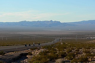
The Desert National Wildlife Refuge is a protected wildlife refuge, administered by the U.S. Fish and Wildlife Service, located north of Las Vegas, Nevada, in northwestern Clark and southwestern Lincoln counties, with much of its land area lying within the southeastern section of the Nevada Test and Training Range. The Desert NWR, created on May 20, 1936, is the largest wildlife refuge in the lower 48 states of the United States, encompassing 1.615 million acres (6,540 km2) of the Mojave Desert in the southern part of Nevada. The refuge was originally established at 2.25 million acres. In 1940 840,000 acres were transferred to the Department of Defense.
The Ash Meadows National Wildlife Refuge is a protected wildlife refuge located in the Amargosa Valley of southern Nye County, in southwestern Nevada. It is directly east of Death Valley National Park, and is 90 mi (140 km) west-northwest of Las Vegas.

The Moapa Valley National Wildlife Refuge (MVNWR) is a protected wildlife refuge administered by the U.S. Fish and Wildlife Service, located in the Warm Springs Natural Area in the Moapa Valley of Clark County, Nevada. The refuge is east of Death Valley and 60 miles (97 km) northeast of Las Vegas, Nevada.

The Amargosa Desert is located in Nye County in western Nevada, United States, along the California–Nevada border, comprising the northeastern portion of the geographic Amargosa Valley, north of the Ash Meadows National Wildlife Refuge.

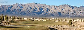
The Sheep Range is located north of Las Vegas, Nevada in the United States. It is found in both Clark and Lincoln Counties in the Desert National Wildlife Refuge. The mountains reach a peak at Hayford Peak, 9,912 feet (3,021 m) above sea level between the Las Vegas Range to the east and the Desert Range to the west. The Sheep Range lies in a generally north-south direction.

The Kofa Mountains of Yuma and La Paz counties in Arizona is the central mountain range of the Kofa National Wildlife Refuge. The range lies about 60 miles northeast of Yuma in the southwestern part of the state. Kofa Wilderness takes up 547,719 acres of the refuge, making it the second largest wilderness area in Arizona. The equally extensive Castle Dome Mountains comprise the southern refuge border; the western end of the Tank Mountains are in the southeast of the wildlife refuge, and the New Water Wilderness in the New Water Mountains ends the extension of the Kofa National Wildlife Refuge to the north. Scenic "King Valley" is south of the Kofa Mountains between the Castle Dome Mountains.

The Altar Valley is a 45-mile (72 km) long north–south valley, trending slightly northeast from Sasabe, Arizona on the Mexico border to the Avra Valley west of the Tucson Mountains. It is delimited by Arizona State Route 86, from east-to-west on the north separating it from the Avra Valley which then trends northwesterly, merging into the plains and drainage of the Santa Cruz River.
Eldorado Valley, or El Dorado Valley, is a Great Basin valley in the Mojave Desert southeast of Las Vegas and southwest of Boulder City, Nevada. The valley is endorheic, containing the Eldorado Dry Lake. The Great Basin Divide, transects ridgelines and saddles, on the north, northeast, east, and south around the valley, as the valley sits on the east of the McCullough Range, a Great Basin massif, on the Great Basin Divide at its north terminus and its south terminus. Much of the valley is protected as part of Avi Kwa Ame National Monument.

The San Augustin Mountains are a small mountain subrange located at the southern terminus of the San Andres Mountains east of Las Cruces, New Mexico.

The Poachie Range is a moderate length mountain range and massif in southeast Mohave County, Arizona, and the extreme southwest corner of Yavapai County; the range also abuts the northeast corner of La Paz County. The Poachie Range massif is bordered by the south-flowing Big Sandy River on its west, and the west-flowing Santa Maria River on its south; both rivers converge at the Poachie Range's southwest at Alamo Lake in Alamo Lake State Park.

The Lakeside Mountains are about a 34 miles (55 km) long mountain range located on the southwest perimeter of the Great Salt Lake; the range is located in northeast Tooele County and south Box Elder County in Utah, United States.

The Gilson Mountains are an 11-mile (18 km) long almost circular, small mountain range adjacent the north terminus of the Canyon Mountains,, located in far eastern Juab County, Utah, United States.

The Cedar Valley of Iron County, Utah, United States is a 25-mile (40 km) long valley located in the southeast of the county, against the Hurricane Cliffs which border the Cedar Mountains and the Markagunt Plateau.
The Black Mountains is a 30-mile (48 km) long mountain range in northeastern Iron County and southeastern Beaver County in southwestern Utah, United States.

Swasey Mountain is the north section of the House Range of northwest Millard County, Utah, United States; the extreme north of Swasey Mountain extends into south Juab County.

The Nellis Air Force Base Complex is the southern Nevada military region of federal facilities and lands, e.g., currently and formerly used for military and associated testing and training such as Atomic Energy Commission atmospheric nuclear detonations of the Cold War. The largest land area of the complex is the Nevada Test and Training Range, and numerous Formerly Used Defense Sites remain federal lands of the complex. Most of the facilities are controlled by the United States Air Force and/or the Bureau of Land Management, and many of the controlling units are based at Creech and Nellis Air Force Bases. Initiated by a 1939 military reconnaissance for a bombing range, federal acquisition began in 1940, and McCarran Field became the World War II training area's 1st of 3 Nevada World War II Army Airfields and 10 auxiliary fields. The area's first military unit was initially headquartered in the Las Vegas Federal Building while the WWII Las Vegas Army Airfield buildings were constructed.

Corn Creek is an unincorporated community in Clark County, Nevada, United States. The community is located along the former Las Vegas and Tonopah Railroad where it had a station. It is approximately 7.5 miles from the Las Vegas city limits by road and is situated south of the Desert National Wildlife Refuge border and bordered to the west, south, and east with the Tule Springs Fossil Beds National Monument.