List
| Name | Location | Date Listed | Grid Ref. [note 1] | Geo-coordinates | Notes | LB Number [note 2] | Image |
|---|---|---|---|---|---|---|---|
| Smiddyhill Bridge | 55°50′36″N2°29′10″W / 55.84326°N 2.486101°W | Category B | 206 |  Upload Photo | |||
| Cranshaws Farmhouse Including Sundial | 55°50′52″N2°30′35″W / 55.847819°N 2.509603°W | Category C(S) | 44908 | Upload Photo | |||
| Cranshaws Castle Including Sundial, Covered Well And Garden Walls | 55°50′55″N2°30′35″W / 55.848546°N 2.509789°W | Category A | 4093 | 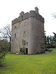 | |||
| Cranshaws Manse Including Outbuildings And Garden Walls, Boundary Wall, Gatepiers And Gates | 55°50′58″N2°29′38″W / 55.849483°N 2.493909°W | Category C(S) | 44909 |  | |||
| Ellemford Bridge | 55°49′58″N2°26′03″W / 55.832852°N 2.434277°W | Category B | 205 | Upload Photo | |||
| Cranshaws Farm, Gateway To Stable Courtyard Including Gates And Pal Stone | 55°50′55″N2°30′31″W / 55.84874°N 2.508625°W | Category B | 44906 | Upload Photo | |||
| Cranshaws Farm, Stable Courtyard | 55°50′55″N2°30′33″W / 55.848567°N 2.509214°W | Category C(S) | 44907 | Upload Photo | |||
| Broombank | 55°49′53″N2°28′06″W / 55.831495°N 2.468457°W | Category C(S) | 44905 | Upload Photo | |||
| Cranshaws Church (Church Of Scotland) Including Graveyard, Gatepiers And Gates | 55°50′56″N2°29′35″W / 55.848803°N 2.49299°W | Category A | 201 | 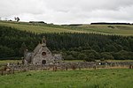 | |||
| Cranshaws Schoolhouse Including Boundary Wall And Gatepiers | 55°51′05″N2°29′43″W / 55.851462°N 2.495404°W | Category B | 44910 | Upload Photo |