List
| Name | Location | Date Listed | Grid Ref. [note 1] | Geo-coordinates | Notes | LB Number [note 2] | Image |
|---|---|---|---|---|---|---|---|
| Spottiswoode, Stable Block, Groom's House, Dog Kennel, "Bear's Den", Glasshouse, Sundial And Rustic Shelter In Walled Garden, Icehouse, Doocot And Well, And Boundary Walls To Former Spottiswoode House | 55°44′23″N2°37′53″W / 55.739774°N 2.631388°W | Category B | 19653 |  | |||
| Wedderlie House | 55°45′21″N2°34′34″W / 55.755823°N 2.576104°W | Category A | 19740 | 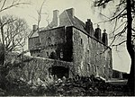 | |||
| Bassendean House | 55°42′18″N2°35′37″W / 55.704929°N 2.59359°W | Category B | 15345 | | |||
| Spottiswoode, Pyatshaw Archway | 55°43′32″N2°39′49″W / 55.725568°N 2.663702°W | Category C(S) | 19651 | | |||
| Spottiswoode, Bruntaburn Archway | 55°44′22″N2°38′29″W / 55.739462°N 2.641321°W | Category C(S) | 19652 | | |||
| Spottiswoode, West Lodge | 55°44′22″N2°38′28″W / 55.739516°N 2.641163°W | Category C(S) | 17418 | | |||
| Spottiswoode, Eagle Or Clock Lodges | 55°43′11″N2°37′15″W / 55.719683°N 2.620828°W | Category B | 19654 | | |||
| Ruin Of Old Church And Graveyard, Westruther | 55°44′33″N2°35′03″W / 55.742523°N 2.584126°W | Category B | 15343 | | |||
| Ruin Of Bassendean Church (St Mary) | 55°42′13″N2°35′20″W / 55.703639°N 2.588972°W | Category B | 15344 | | |||
| The Old Thistle Inn, Westruther | 55°44′32″N2°35′05″W / 55.742143°N 2.58479°W | Category B | 15346 | | |||
| Evelaw Tower | 55°45′55″N2°32′30″W / 55.765235°N 2.541579°W | Category B | 17419 | | |||
| Coach Building Wedderlie | 55°45′23″N2°34′30″W / 55.756305°N 2.575011°W | Category B | 15347 | |