List
| Name | Location | Date Listed | Grid Ref. [note 1] | Geo-coordinates | Notes | LB Number [note 2] | Image |
|---|---|---|---|---|---|---|---|
| Sunlaws Hotel Stable Range | 55°33′32″N2°28′10″W / 55.558781°N 2.469486°W | Category B | 19713 |  Upload Photo | |||
| Footbridge, Roxburgh Viaduct | 55°33′59″N2°28′27″W / 55.566472°N 2.474081°W | Category B | 15100 | Upload Photo | |||
| Sunlaws Hotel And Gatepiers | 55°33′31″N2°28′09″W / 55.558477°N 2.469102°W | Category B | 15101 | Upload Photo | |||
| Roxburgh Church And Graveyard | 55°34′08″N2°28′38″W / 55.568887°N 2.477123°W | Category B | 15095 | Upload Photo | |||
| Fairnington House | 55°32′42″N2°33′45″W / 55.544947°N 2.562365°W | Category B | 19712 | Upload Photo | |||
| Railway Viaduct, Roxburgh | 55°33′59″N2°28′27″W / 55.566472°N 2.474081°W | Category A | 15097 | 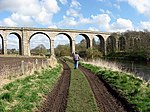 | |||
| Kersmains | 55°34′45″N2°28′28″W / 55.579159°N 2.474393°W | Category B | 15098 | Upload Photo | |||
| Baron's Folly | 55°32′01″N2°34′35″W / 55.533542°N 2.576366°W | Category C(S) | 15099 | Upload Photo | |||
| Roxburgh Castle | 55°35′47″N2°27′25″W / 55.596333°N 2.456875°W | Category B | 13874 | Upload Photo |