List of localities and stopping places related to the Trans Australian railway line

Last updated

The Trans-Australian Railway line has a very ambiguous term, Nullarbor. This list is relative to the 1917 construction of railway line that went from Kalgoorlie to Port Augusta [1] [2] [3]

Trans-Australian Railway railway line

The Trans-Australian Railway crosses the Nullarbor Plain of Australia from Port Augusta in South Australia to Kalgoorlie in Western Australia. It includes a 478-kilometre (297 mi) stretch of dead-straight track, the world's longest, between the 797 km (495 mi) post west of Ooldea and the 1,275 km (792 mi) post west of Loongana.

Nullarbor can refer to:

Kalgoorlie railway station

Kalgoorlie railway station is the most eastern attended station in Western Australia, located at the eastern terminus of the Eastern Goldfields Railway. It serves the city of Kalgoorlie. Beyond Kalgoorlie the line continues east as the Trans-Australian Railway.

Contents

Western Australia

Parkeston is a suburb of the city of Kalgoorlie, Western Australia, located 3 km east of the city centre. At the 2016 census, it had a population of 60 people, down from 69 in 2006.

Golden Ridge, Western Australia Town in Western Australia

Golden Ridge is an abandoned town in Western Australia located 615 kilometres (382 mi) east of Perth just off the Mount Monger Road in the Goldfields-Esperance region of Western Australia.

Zanthus, Western Australia Town in Western Australia

Zanthus is a remote outpost on the Trans-Australian rail line approximately 210 kilometres (130 mi) east of the regional city of Kalgoorlie in the Goldfields-Esperance region of Western Australia.

WA-SA Border 1050.910 km

South Australia

Cook, South Australia South Australia

Cook is a railway station and crossing loop located in the Australian state of South Australia on the Trans-Australian Railway in the locality of Nullarbor about 826 kilometres (513 mi) west by rail of Port Augusta and about 100 kilometres (62 mi) north of the Eyre Highway via an unsealed road.

Ooldea, South Australia Town in South Australia

Ooldea is a tiny settlement in South Australia. It is on the eastern edge of the Nullarbor Plain, 863 km (536 mi) west of Port Augusta on the Trans-Australian Railway. Ooldea is 143 km (89 mi) from the bitumen Eyre Highway.

Tarcoola railway station

Tarcoola railway station is located on the Trans-Australian Railway. It serves the town of Tarcoola and is the northern junction of the Sydney-Perth and Adelaide-Darwin railways, which share approximately 530 kilometres (329 mi) of track between Tarcoola and Crystal Brook.

Access

Most of the locations along the railway line exist in reserves with limited or no access allowable, or are positioned next to a road that has been closed and has no access possible: the few locations that are accessible have either landing strips for access by plane and roads that run north from the Eyre Highway. Most of the identified locations in this list are ruins or have very few services or facilities.

Eyre Highway highway in South Australia and Western Australia

Eyre Highway is a 1,660-kilometre (1,030 mi) highway linking Western Australia and South Australia via the Nullarbor Plain. Signed as National Highways 1 and A1, it forms part of Highway 1 and the Australian National Highway network linking Perth and Adelaide. It was named after explorer Edward John Eyre, who was the first European to cross the Nullarbor by land, in 1840–1841. Eyre Highway runs from Norseman in Western Australia, past Eucla, to the state border. Continuing to the South Australian town of Ceduna, it then crosses the top of the Eyre Peninsula before reaching the city of Port Augusta in South Australia.

See also

<i>Indian Pacific</i> transcontinental rail service in Australia

The Indian Pacific is an Australian passenger rail service that operates between Sydney, on the Pacific Ocean, and Perth, on the Indian Ocean. It is one of the few truly transcontinental trains in the world. The train first ran in February 1970 after the completion of gauge conversion projects in South and Western Australia.

Nullarbor Plain geographical feature in Western Australia and South Australia

The Nullarbor Plain is part of the area of flat, almost treeless, arid or semi-arid country of southern Australia, located on the Great Australian Bight coast with the Great Victoria Desert to its north. It is the world's largest single exposure of limestone bedrock, and occupies an area of about 200,000 square kilometres (77,000 sq mi). At its widest point, it stretches about 1,100 kilometres (684 mi) from east to west across the border between South Australia and Western Australia.

Related Research Articles

Eucla, Western Australia Town in Western Australia

Eucla is the easternmost locality in Western Australia, located in the Goldfields-Esperance region of Western Australia along the Eyre Highway, approximately 11 kilometres (7 mi) west of the South Australian border. At the 2016 Australian census, Eucla had a population of 53.

Zanthus train collision

The Zanthus train collision occurred at a crossing loop on the Trans-Australian Railway between Perth and Sydney on 18 August 1999. It is located 739 km (459 mi) east northeast of Perth and 202 km (126 mi) east of Kalgoorlie in Western Australia, on the Nullarbor Plain.

Eastern Goldfields Railway

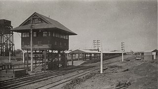
The Eastern Goldfields Railway was built in the 1890s by the Western Australian Government Railways to connect Perth with the Eastern Goldfields at Coolgardie and Kalgoorlie.

Rawlinna, Western Australia Town in Western Australia

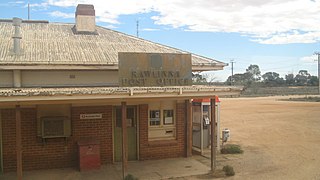
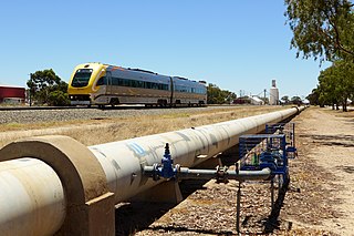
Rawlinna is a remote locality and railway siding on the Trans-Australian Railway in Western Australia. It is also the site of a small lime mine, in which the lime is extracted from the limestone that is prevalent in the area. The lime is mostly used in the gold production process at Kalgoorlie.

Commonwealth Railways Australian railway (1912–1975)

The Commonwealth Railways were established in 1917 by the Government of Australia with the Commonwealth Railways Act to administer the Trans-Australia and Port Augusta to Darwin railways. It was absorbed into Australian National in 1975.

Piesseville, Western Australia Town in Western Australia

Piesseville is a small town in the Wheatbelt region of Western Australia, 211 kilometres (131 mi) south-east of Perth on the Great Southern Highway between Narrogin and Wagin. It is also on the Great Southern Railway. At the 2016 census, Piesseville had a population of 59., being a significant decrease from 246 at the 2006 census

Tea and Sugar Train

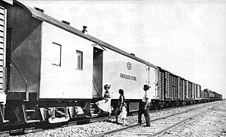
The Tea & Sugar was a dedicated train that serviced isolated Australian towns on the Nullarbor Plain between Port Augusta and Kalgoorlie along the Trans-Australian Railway. The train was significant because it provided all the supplies used by remote towns in South and Western Australia.

Buningonia Land District Cadastral in Western Australia

Buningonia Land District is a land district of Western Australia, located within the Eastern Land Division on the Nullarbor Plain. It spans roughly 30°10'S - 32°00'S in latitude and 122°15'E - 124°00'E in longitude.

Nurina Land District Cadastral in Western Australia

Nurina Land District is a land district of Western Australia, located within the Eucla Land Division on the Nullarbor Plain. It spans roughly 31°00'S - 32°20'S in latitude and 125°30'E - 127°30'E in longitude.

Yorkey Crossing South Australia

Yorkey Crossing is a ford in the Australian state of South Australia located at the head of Spencer Gulf in the gazetted locality of Emeroo about 4 nautical miles north of Port Augusta. As of 2014, it is the site of an unsealed road that serves as a by-pass route around the head of the gulf for 'over dimensional vehicles', which are not permitted to cross the gulf using the Port Augusta Bridge. It is also near the location of the crossing for the Kalgoorlie to Port Augusta Railway built after 1911. It is considered to be the most north easterly part of Eyre Peninsula.

Carnegie Station pastoral lease in Western Australia

Carnegie Station, or Carnegie pastoral lease, is located north of Laverton and east of Wiluna in Western Australia and is the most eastern of pastoral leases found on the Gunbarrel Highway.

Maralinga to Emu Road

The Maralinga to Emu Road is a remote unsealed outback track that links Maralinga to Emu in the western region of South Australia. It was built by Len Beadell for the Weapons Research Establishment of Salisbury, South Australia in 1955.

Vokes Hill Corner to Cook Road track in South Australia

The Vokes Hill Corner to Cook Road is a remote unsealed outback track that links Vokes Hill Corner on the Anne Beadell Highway to Cook on the Trans-Australian Railway in the far west of South Australia. It was built by Len Beadell for the Weapons Research Establishment of Salisbury, South Australia in late 1961.

References

  1. (1927 Travel in comfort across Australia on the Trans-Australian Railway. Melbourne : Commonwealth Railways. internal map titled Map shewing Connections between Capital Cities via Trans- Australian Railway
  2. Hema Maps (Firm) & Zell, Len & Glover, Ian (Ian Thomas), 1949 & Sakker, Elizabeth & Wild Discovery Guides (Firm) 2007, Australia's great desert tracks atlas & guide Hema Maps & Wild Discovery Guides, Eight Mile Plains, Qld ISBN   978-1-86500-382-5 (pbk.) pp.210-215, 238-239
  3. Updated to reflect the 2010 ARTC Network Diagram including Kilometreages from Coonamia.