Planned/Future Mergers
| Core city | ||
|---|---|---|
| Cities | ||
| Districts | ||
Here is a list of mergers in Akita Prefecture, Japan since the Heisei era.
| Core city | ||
|---|---|---|
| Cities | ||
| Districts | ||
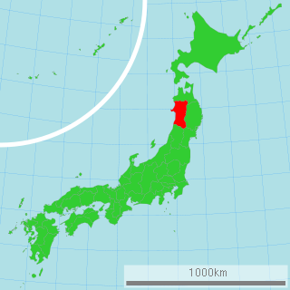
Akita Prefecture is a prefecture of Japan located in the Tōhoku region of Honshu. Its population is approximately 966,000 and its geographic area is 11,637 km2. Akita Prefecture is bordered by Aomori Prefecture to the north, Iwate Prefecture to the east, Miyagi Prefecture to the southeast, and Yamagata Prefecture to the south.
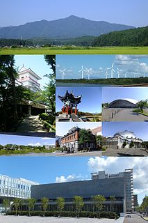
Akita 'Autumn field' is the capital city of Akita Prefecture, Japan, and has been designated a core city since 1 April 1997. As of 1 January 2020, the city has an estimated population of 305,625, 136,628 households and a population density of 340 persons per km2. The total area of the city is 906.07 square kilometres (349.84 sq mi).

Yokote is a city located in Akita Prefecture, Japan. As of 31 December 2019, the city had an estimated population of 89,574 in 34,240 households, and a population density of 130 persons per km². The total area of the city is 693.04 km2 (267.58 sq mi).

Yuzawa is a city located in Akita Prefecture, Japan. As of 31 December 2019, the city had an estimated population of 44,346 in 17,789 households, and a population density of 56 persons per km². The total area of the city is 790.91 km2 (305.37 sq mi). Yuzawa claims to be the birthplace of the famous Heian period poet Ono no Komachi.

Dewa Province was a province of Japan comprising modern-day Yamagata Prefecture and Akita Prefecture, except for the city of Kazuno and the town of Kosaka. Dewa bordered on Mutsu and Echigō Provinces. Its abbreviated form name was Ushū (羽州).

Ugo Province is an old province of Japan in the area of Akita Prefecture and some parts of Yamagata Prefecture. It was sometimes called Ushū (羽州), with Uzen Province.

Kitaakita District is a rural district located in Akita Prefecture, Japan.

Yamamoto District is a rural district located in Akita Prefecture, Japan.

Kawabe District was a former rural district located in southern Akita, Japan. On October 1, 2005, its remaining components, the towns of Kawabe and Yūwa merged into the city of Akita, upon which Kawabe District was dissolved and ceased to exist as an administrative unit.

Senboku District is a rural district located in Akita, Japan.

Ōmori was a town located in Hiraka District, Akita Prefecture, Japan.
Jūmonji was a town located in Hiraka District, Akita Prefecture, Japan.

Hiraka was a rural district located in southern Akita, Japan. On 1 October 2005, its remaining components- the towns of Hiraka, Jūmonji, Masuda, Omonogawa, Ōmori; and the villages of Sannai and Taiyū- merged into the city of Yokote, upon which Hiraka District was dissolved and ceased to exist as an administrative unit.

Ogachi was a town located in Ogachi District, Akita Prefecture, Japan.
Minase was a village located in Ogachi District, Akita Prefecture, Japan.

Ogachi District is a rural district located in Akita Prefecture, Japan.
The Ushū Kaidō (羽州街道) was a subroute of the Ōshū Kaidō and the Sendaidō in Japan. It breaks off from the Sendaidō at Kōri-juku in the modern-day Koori in Fukushima Prefecture. It connects to Aburakawa-juku along Matsumaedō, the other subroute of the Ōshū Kaidō. It is traced by National Routes 13 and 7. It was established after Tokugawa Ieyasu called for the construction of routes connecting the capital of Edo with other parts of Japan.

The Akita Expressway is a national expressway in the Tōhoku region of Japan. The 229.2-kilometer-long (142.4 mi) expressway begins at an interchange with the Tōhoku Expressway in Kitakami, Iwate from where it proceeds northwest towards the capital of Akita Prefecture, Akita. From there, it travels northeast back to another interchange along the Tōhoku Expressway in the town of Kosaka. It is jointly owned and operated by East Nippon Expressway Company and the Ministry of Land, Infrastructure, Transport and Tourism (MLIT). The Akita Expressway is numbered E7 between Kosaka and Kitakami Junctions and E46 between Kitakami and Kawabe Junctions under the MLIT's "2016 Proposal for Realization of Expressway Numbering."
National Route 105 is a national highway of Japan that traverses the prefecture of Akita in a southwest–northeast routing. It connects the city of Kitaakita in north-central Akita Prefecture and Yurihonjō on the prefecture's southwestern coast. It has a total length of 170.0 kilometers (105.6 mi).