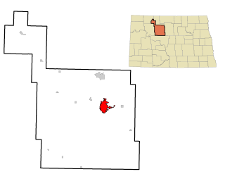
Minot is a city in and the county seat of Ward County, North Dakota, United States, in the state's north-central region. It is most widely known for the Air Force base located approximately 15 miles (24 km) north of the city. With a population of 40,888 at the 2010 census, Minot is the fourth largest city in the state and a trading center for a large portion of northern North Dakota, southwestern Manitoba, and southeastern Saskatchewan. Founded in 1886 during the construction of the Great Northern Railway, Minot is also known as "Magic City", commemorating its remarkable growth in size over a short time.

Oak Cliff is a neighborhood of Dallas, Texas, that was formerly a separate town in Dallas County; Dallas annexed Oak Cliff in 1901. It has since retained a distinct neighborhood identity as one of Dallas' older established neighborhoods.

Minot State University is a public university in Minot, North Dakota. Founded in 1913 as a normal school, Minot State University is the third-largest university in North Dakota, offering undergraduate and graduate degree programs.
This is a list of neighborhoods in Kansas City, Missouri and Kansas City, Kansas.
The geography of Minot, North Dakota is treated extensively in this article.

Old Main, constructed in 1907-1908, is a historic building at Dakota College at Bottineau, a two-year college in Bottineau, North Dakota. The building previously housed the North Dakota School of Forestry. The building is listed in the National Register of Historic Places.

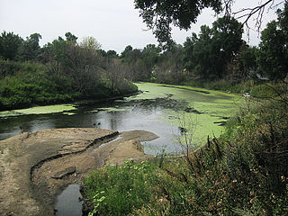
Oak Park is a park and surrounding neighborhood in the Souris Valley in Minot, North Dakota. The wooded park is over 50-acres in size. In addition to the namesake oak trees, ash and elm trees are also commonly found in the park. The Souris Valley Birding Club meets regularly at the park to watch hooded mergansers, wood ducks, Canada geese, kingfishers, Great blue herons, and other birds. The eastern edge of the park borders the Souris River, also called the Mouse River. A small oxbow lake is also located in the park. Oak Park has numerous walking/biking trails, both paved and unpaved; a splash pad; and volleyball court. The park is home to concerts in the park run by the Minot Area Council of Arts, through their Arts in the Park program. On Tuesdays, Thursdays, and Saturdays from July to October, a farmers market also operates out of Oak Park. In 2011, the farmers market at the park was temporarily moved to the North Hill Soccer Complex because of the 2011 Souris River flood. On August 4, 2010, a man was found dead in the park from an apparent suicide. Oak Park was the winner of the 2011 America's Favorite Park Contest sponsored by Coca-Cola and is set to receive a $100,000 grant.

Haxby & Gillespie was an architectural firm from Fargo, North Dakota. R. J. Haxby and William D. Gillespie were the partners. The firm "produced a number of important buildings throughout North Dakota." They designed many notable public, educational, commercial, and church buildings, in North Dakota, Minnesota, and Montana.

William F. Kurke (1889–1965) was a prolific architect in North Dakota.
West Minot is a neighborhood in Minot, North Dakota, located in the Souris River Valley. It borders Oak Park to the South, North Hill to the North, Bel Air to the west and Nubbin Park to the east. The neighborhood is largely residential and there are no commercial thoroughfares, which run through the neighborhood. It received its name when at the time it was the westernmost neighborhood in Minot. Today, there are neighborhoods, such as Bel Air further west of here, but the area has retained the name West Minot. West Minot is home to the Quentin N. Burdick Jobs Center, Minot's Hebrew Cemetery and the West Minot Church of God.

North Hill is a neighborhood in Minot, North Dakota, located north of the Souris River, above the Souris River Valley. It is a primarily residential neighborhood, though there are industries and businesses in the area, primarily along North Broadway and 21st Ave NW. North Hill is also home to Minot International Airport.

South Hill is a neighborhood in Minot, North Dakota, located south of the Souris River, above the Souris River Valley. It is a primarily residential neighborhood, although there are commercial zones along South Broadway, Twentieth Avenue South and around the Dakota Square Mall.
West Oaks is a neighborhood in Minot, North Dakota. The neighborhood is bounded by Oak Park to the North, the Souris River to the east, the Soo Line Railroad tracks to the south and Sixteenth Street SW. The neighborhood is home to the West Oaks Animal Hospital, the West Oaks Apartments, Harleys Automotive Center and gas station, Eagles Wings Community Fellowship and a number of single family homes. Oak Park's south entrance is located in the neighborhood on Oak Drive SW. A thin strip of land between the Oak Park Oxbow and the Souris River connects the park with the neighborhood. The neighborhood was greatly impacted by the Souris River flood in 2011. In June 2011, the Washington Post printed a story about the Minot flood on the front page with an accompanying photograph of Harleys and the nearby Arrowhead Mall. Water inundated both structures, despite the large dikes constructed around both buildings. On June 26, 2011, the New York Times also printed an article with an aerial photograph of the flooded Harleys. Similar aerial photographs of the flood at that location are displayed at the Harleys gas station.