Administrative divisions
Electoral wards
This is a list of electoral wards in Neath Port Talbot:
Electoral wards of Neath Port Talbot county borough | |
|---|---|
| Aberavon | |
| Neath | |
This is a list of places in the Neath Port Talbot County Borough in Wales.
This is a list of electoral wards in Neath Port Talbot:
Electoral wards of Neath Port Talbot county borough | |
|---|---|
| Aberavon | |
| Neath | |
This is a list of notable places for historical, cultural or topical reasons:

Port Talbot is a town and community in the county borough of Neath Port Talbot, Wales, situated on the east side of Swansea Bay, approximately eight miles from Swansea. The Port Talbot Steelworks covers a large area of land which dominates the south east of the town. It is one of the biggest steelworks in the world, but has been under threat of closure since the 1980s. The population was 31,550 in 2021, comprising about a fifth of the 141,931 population of Neath Port Talbot.

Neath is a market town and community situated in the Neath Port Talbot County Borough, Wales. The town had a population of 50,658 in 2011. The community of the parish of Neath had a population of 19,258 in 2011. Historically in Glamorgan, the town is located on the River Neath, seven miles east-northeast of Swansea.

Neath Port Talbot is a county borough in the south-west of Wales. Its principal towns are Neath, Port Talbot, Briton Ferry and Pontardawe. The county borough borders Bridgend County Borough and Rhondda Cynon Taf to the east, Powys and Carmarthenshire to the north; and Swansea to the west.

Briton Ferry is a town and community in the county borough of Neath Port Talbot, Wales. The Welsh name may indicate that the church, llan, is protected from the wind, awel. Alternatively, Sawel may be a derivative of Saul, St Paul's earlier name, who, supposedly, once landed at Briton Ferry. An alternative Welsh name unused today is Rhyd y Brython, a direct translation of Briton Ferry. The Normans referred to the River crossing as La Brittonne and Leland in 1540 as Britanne Fery.

Aberavon is a town and community in Neath Port Talbot county borough, Wales. The town derived its name from being near the mouth of the river Afan, which also gave its name to a medieval lordship. Today it is essentially a district of Port Talbot, covering the central and south western part of the town. Aberavon is also the name of the nearby Blue Flag beach and the parish covering the same area.

River Neath is a river in south Wales running south west from the point at which its headwaters arising in the Brecon Beacons National Park converge to its mouth at Baglan Bay below Briton Ferry on the east side of Swansea Bay.

Margam Castle, Margam, Port Talbot, Wales, is a late Georgian country house built for Christopher Rice Mansel Talbot. Designed by Thomas Hopper, the castle was constructed in a Tudor Revival style over a five-year period, from 1830 to 1835. The site had been occupied for some 4,000 years. A Grade I listed building, the castle is now in the care of Neath Port Talbot County Borough Council. The castle stands within Margam Country Park, the former estate to the house. The park is listed at Grade I on the Cadw/ICOMOS Register of Parks and Gardens of Special Historic Interest in Wales.

Margam is a suburb and community of Port Talbot in the Welsh county borough of Neath Port Talbot, Wales, close to junction 39 of the M4 motorway. The community had a population of 3,017 in 2011; the built up area being larger and extending into Taibach community.

Margam Country Park is a country park estate in Wales, of around 850 acres (3.4 km2). It is situated in Margam, about 2 miles (3 km) from Port Talbot in south Wales. It was once owned by the Mansel Talbot family and is now owned and administered by the local council, Neath Port Talbot County Borough Council. Situated within the park are three notable buildings: Margam Abbey, a Cistercian monastery; Margam Castle, a neo-Gothic country house that was once the seat of the Mansel Talbot family; and the 18th-century Orangery. The park is designated Grade I on the Cadw/ICOMOS Register of Parks and Gardens of Special Historic Interest in Wales.

Cwmafan, also known as Cwmavon, is a large village and community in the Afan valley in Wales, lying within Neath Port Talbot County Borough. It had a population of 5,603 in 2001, increasing slightly to 5,615 at the 2011 Census. Cwmafan is known for having a high percentage of Welsh speakers. In many ways it is a suburb of the nearby town of Port Talbot which is less than 2 miles (3 km) to the south. The literal translation of Cwmafan from Welsh to English is complex, Cwm means valley with Afan as the name of the river flowing through, hence the village residing within the Afan Valley. It could be a version of Afon which means river, so literally the "River Valley", this is common in Wales and the UK with many rivers being called Afon or Avon. There is also a Saint Afan, which it is possible the river was named after. There have been other suggestions but none accepted locally.
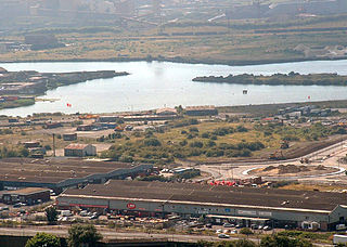
The Port of Port Talbot is located on the River Afan estuary next to Port Talbot Steelworks in the industrial town of Port Talbot, South Wales. The whole basin complex covers about 500 acres (2.0 km2), consisting of: an inner set of floating docks, developed from 1834 onwards; and an outer tidal basin, completed in 1970. Owned and operated by Associated British Ports, the tidal basin has the deepest berthing facilities in the Severn estuary and is one of only a few harbours in the UK capable of handling Capesize vessels of up to 170,000 tonnes deadweight (DWT), mostly for the import of iron ore and coal for use by nearby Port Talbot Steelworks.
The Rhondda and Swansea Bay Railway was a Welsh railway company formed to connect the upper end of the Rhondda Fawr with Swansea, with the main objective of transporting coal and other minerals to Swansea docks. It was incorporated in 1882, but at first the connection to Swansea from Briton Ferry was refused.
The Neath Guardian was a local weekly newspaper published between 1925 and 2009 covering Neath, Wales, and the surrounding area. At the time of its closure, it was published weekly, on a Wednesday, in the tabloid format by Media Wales, part of the Trinity Mirror group.

The A4241 Port Talbot Peripheral Distributor Road is a distributor road serving Port Talbot, Wales.

In the United Kingdom, the term listed building refers to a building or other structure officially designated as being of special architectural, historical, or cultural significance; Grade II* structures are those considered to be "particularly important buildings of more than special interest". Listing was begun by a provision in the Town and Country Planning Act 1947. Once listed, strict limitations are imposed on the modifications allowed to a building's structure or fittings. In Wales, the authority for listing under the Planning Act 1990 rests with Cadw.

The electoral ward of Aberavon electoral ward includes the communities of Baglan and Baglan Bay, in Neath Port Talbot county borough, Wales. Baglan falls within the parliamentary constituency of Aberavon.
Neath Port Talbot is a county borough in South Wales. It covers an area of 441 km2 (170 sq mi) and in 2021 the population was approximately 141,900.

The cuisine of Neath Port Talbot is distinguished by the area's long and varied history. During the Roman era, Neath was an important garrison on the road to west Wales. During the Middle Ages two great monasteries dominated the area and owned much of the agricultural land. After the dissolution of the monasteries the gentry owned the best land but with the onset of the Industrial Revolution a centre of industry developed around Neath. During the 20th century Baglan and Port Talbot became important centres for petrochemical products and steelmaking.