The following is a list of service reservoirs in Singapore . There are currently 9 service reservoirs operating in Singapore which are used to store potable water.
Changi Creek Reservoir | |
---|---|
Coordinates | 1°23′11″N103°59′42″E / 1.38639°N 103.99500°E |
Type | reservoir |
Basin countries | Singapore |
Changi Creek Reservoir is a small service reservoir located to the north of Singapore Changi Airport in Singapore. The reservoir supplements and provides backup water supply for the airport. It was formed by damming the headwaters of a small river, Changi Creek, which empties into Sungei Changi and thence into the Serangoon Harbour.
Rainfall from the runways and surrounding green areas is collected in the nearby South End Reservoir. Changi Creek Reservoir is used to balance flows during incoming tides and high rainfall. [1]
Fort Canning Reservoir | |
---|---|
Fort Canning Service Reservoir | |
Location | Fort Canning Singapore |
Coordinates | 1°17′37″N103°50′48″E / 1.29361°N 103.84667°E |
Type | Reservoir |
Basin countries | Singapore |
Built | 1927 |
Surface area | 27,875.5 square metres (300,049 sq ft) |
The Fort Canning Service Reservoir (Chinese: 福康宁备水池) is an underground reservoir located on top of Fort Canning Hill. [2] Construction of the reservoir began on 1 April 1927 on the former site of a large artillery barracks and parade ground to help supplement the large impounding reservoirs. The reservoir was constructed in two sections: the southern section was ready for water storage by 1 August 1928, and the final work completed by the middle of January 1929. [3] Water is pumped from the large reservoirs into the service reservoirs, thus enabling water to flow down the hill into houses.
Earlier service reservoirs were built on Mount Emily (1878), Pearl's Hill (1903), and Bukit Timah Hill. The size of the Fort Canning Reservoir is 30 million gallons. [4]
A spring used to exist on the west side of Fort Canning Hill and served as a source of water in the early days of Singapore. The spring was called pancur larangan or "forbidden spring", where the women of the ruler's household were said to bathe in ancient times In early 19th century Singapore, the spring was used to provide clean drinking water for all ships stopping at the port until the demand exceeded the capacity by 1830. The spring then dried up as wells were dug around the hill. [5] A cache of Javanese-style gold ornaments dating to the mid-14th century was discovered when workers were excavating for the reservoir at Fort Canning in 1928. [6] [7]
Jalan Eunos Service Reservoir is a service reservoir located along Kaki Bukit Avenue 4 in Singapore. It is found in the northern part of Kaki Bukit estate near the Paya Lebar Air Base and is therefore part of the Bedok planning area. The reservoir provides water supply to the eastern regions of Singapore and stores treated water mainly from Bedok Reservoir. It can reportedly hold 22 million gallons/ 100,000 cubic metres of water. [8] Access to this service reservoir is restricted unlike the neighbouring Bedok Reservoir.
Jalan Eunos Service Reservoir was first constructed by the British Government in 1956 at an estimated cost of $4 million to improve water pressure in the Geylang, Katong and Changi areas of Singapore, as the Woodleigh Waterworks, constructed in 1912 and still stands today, was inadequate to channel water to the growing population. [9] The reservoir was first expanded in 1971 and was then expanded again in 1974 to increase water supply to the east of Singapore which was developing rapidly and was in need of connection to potable water. [10] As Singapore had gained independence by then, there were also fears that Malaysia would eventually cut off water supply from its reservoirs despite agreements made beforehand. In line with the need of Singapore for self reliance to provide its own water, Bedok Reservoir was then finally completed in 1985 to provide Jalan Eunos Service Reservoir with even more water especially to the residences residing in the east of Singapore. Redevelopments in the area of Kaki Bukit also saw Jalan Eunos which was once linked to the reservoir no longer anywhere near it.
Kallang Service Reservoir, also called Bukit Kalang Service Reservoir, is a service reservoir located within the Central Water Catchment. It is situated south of the Lower Pierce Reservoir, off Island Club Road.
Though called Kallang Service Reservoir, it is located nowhere near to Kallang. It is, however, located within the former Ulu Kallang mukim, as well as within the vicinity of the Bukit Kallang geographic point.
Murnane Service Reservoir is a covered service reservoir near the Bukit Timah Expressway and the Pan Island Expressway in Singapore. The reservoir supplements and provides backup water supply for the western regions of Singapore. Covering an area of 13 acres, it was believed to be the largest covered service reservoir in the world when it was completed in 1956.
The reservoir is named after D. J. Murnane, the longest serving Municipal Water Engineer in Singapore. Its planning began immediately after World War II. [11]
In 2014 the Public Utilities Board announced plans for the Murnane Pipeline project, a new 22km long underground water main running from the Murnane Reservoir to Tanjong Pagar in order to meet future demand, which was expected to double from 30 million gallons per day (mgd) to 60 mgd by 2060. [12] [13] The project was expected to be completed in Q3 2022, and appears to have been completed - to little fanfare - as PUB has since mentioned its completion in a press release in September 2023 about a hike in water prices. [14] [15]
The Pearl's Hill Service reservoir was first mooted in 1897, then built in 1898 to provide additional storage capacity and increase water pressure to Chinatown. [16] [17] The project was described in some detail in a 1902 newspaper report, which highlighted the rapid growth in water demand from 4.1 mgd (average) in May 1900 to 5.4 mgd in 1902. [18] Built of granite and concrete at a cost of $300,000, it was 70 feet higher than the Wilkie Road reservoir which it replaced. The work was undertaken by Municipal Water Engineer Robert Peirce (engineer) and his assistant L M Bell.
Upon completion there were newspaper reports of concerns about the construction quality, stability and leakages from the reservoir. The fact that the reservoir was constructed on top of the hill, rather than sunken into the hill (like Fort Canning reservoir), appears to have been the crux of the public concern. [19]
When filtered water was first imported from Gunong Pulau in Johor in 1929, it was stored in Pearl's Hill Reservoir.
The South End Reservoir is a small service reservoir located to the south of Singapore Changi Airport in Singapore. Rainfall from the runways and surrounding green areas is collected in the reservoir and used for fire-fighting drills and toilet flushing. The reservoir supplies 28–33% of the airport's water and saves the airport around S$390,000 per year. It is linked to the Changi Creek Reservoir to balance flows during incoming tides and high rainfall. [1]
The pond in Yishun Pond Park is a service reservoir which acts as a water catchment area. [20]
Geylang is a planning area and township located on the eastern fringe of the Central Region of Singapore, bordering Hougang and Toa Payoh in the north, Marine Parade in the south, Bedok in the east, and Kallang in the west.
The East Coast Parkway is a fully-controlled access expressway that runs along the southeastern coast of Singapore. It is approximately 16 kilometres (9.9 mi) in length. As of July 2022, it is Singapore's third-longest expressway. The expressway serves a vital function by being the primary highway from the airport to the central area.
Kallang (IPA:/kɑːlɑːŋ/ is a planning area and residential zone located in the Central Region of Singapore.
Simei is an estate located in Tampines Town in the Eastern Region of Singapore. The name Simei is pinyin for "Four Beauties" in Chinese. Formerly known as Tampines South, it was officially renamed to Simei in 1985.
Bedok is a planning area and residential town located in the geographical region of Tanah Merah along the south-eastern coast of the East Region of Singapore. Bedok is bounded by five other planning areas: Paya Lebar to the north, Hougang to the northwest, Tampines to the northeast and east, Geylang to the west and Marine Parade to the southwest. It also shares a maritime boundary with the Singapore Strait to the south and southeast.
The Pan Island Expressway is the oldest and longest expressway in Singapore. It is also Singapore's longest road. The expressway runs from the East Coast Parkway near Changi Airport in the east to Tuas in the west and has a total length of 42.8 kilometres.
The Seletar Expressway is a highway in Singapore that traverses the northern end of the island and joins the Central Expressway (CTE) and the Tampines Expressway (TPE) in Seletar to the Bukit Timah Expressway (BKE) in Kranji.
The following lists events that happened during 1996 in Singapore.
The Bukit Timah Satellite Earth Station is the second satellite earth station in Singapore after Sentosa Satellite Earth Station in Sentosa Island.
Geylang East, as a planning subzone, covers what is more commonly known as Eunos. This is located in Geylang zone in the Central Region of Singapore. The vicinity is served by both Paya Lebar and Eunos MRT stations. This area is distinct from the Geylang East Central and estate, which is adjacent to and west of Eunos.
Sir Laurence Nunns Guillemard was a British civil servant who served as high commissioner in Malaya when it was under the British Empire.
Bartley Road is a major road in Singapore extending from Upper Serangoon Road to Tampines Avenue 10. The road has a distance span of 5.8km. En route, it passes through the areas of Serangoon, Bartley, Paya Lebar, Defu, Kaki Bukit, and Bedok Reservoir.
Occasionally, some parts of Singapore are inundated by floods, usually in the form of flash floods that came about due to intense rainfall over a short period of time. Floods in Singapore are much less severe than floods in other countries, often only lasting a few hours before dissipating on its own.
Kaki Bukit MRT station is an underground Mass Rapid Transit (MRT) station on the Downtown line (DTL). Situated in Kaki Bukit, Singapore, it is located along Kaki Bukit Avenue 1. The station serves the vicinity's residential and industrial developments, including Kaki Bukit Techpark and TechView.
Kaki Bukit is an industrial area located in Bedok in the East Region of Singapore. It is home to many high tech industrial companies and warehouses. There used to be a prison complex called Kaki Bukit Centre, which was converted to a prison school in 2000. It has since moved to Tanah Merah and the Acacia Welfare Home now stands in its place. On the south of Kaki Bukit is Jalan Tenaga and Jalan Damai neighbourhoods of Bedok Reservoir Road. Redevelopments are in the pipeline for Kaki Bukit beyond 2030 when Paya Lebar Airbase, located just north of the estate, relocates to Changi. Not only would land be freed up for use but building height restrictions, that are currently in place for safety reasons because the estate is directly aligned with the airbase runway, would also be lifted. Kaki Bukit is classified by Urban Redevelopment Authority (URA) as a subzone under the planning area of Bedok, its boundaries differ from the constituency boundaries used by the Singapore Parliament.
David Joseph Murnane (1892–1953) was Singapore's longest serving municipal water engineer, serving from 1925 to 1947.
Robert Peirce was a British-born civil engineer who served as Municipal Engineer in Penang, Malaysia and Singapore.
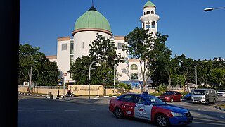
Masjid Alkaff Kampung Melayu, is a mosque located on the junction of Kaki Bukit Avenue 1 and Bedok Reservoir Road in Bedok, Singapore. The institution mainly serves worshippers from the Bedok Reservoir area.
Geylang East Public Library is one of the 26 public libraries established by the National Library Board of Singapore.
A proposed 22 km Potable Water (PW) pipeline from Murnane Service Reservoir to the city will be completed in Q3 2022 to help meet the city's long-term demand.