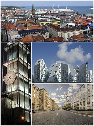
Aarhus is the second-largest city in Denmark and the seat of Aarhus Municipality. It is located on the eastern shore of Jutland in the Kattegat sea and approximately 187 kilometres (116 mi) northwest of Copenhagen.

Brabrand is a postal district of Aarhus Municipality, Denmark. South of Brabrand, in the Aarhus river-valley, is the largest recreational area of Aarhus Municipality, comprising the Brabrand Lake and the meadow-lake of Årslev, with surrounding natural sites.

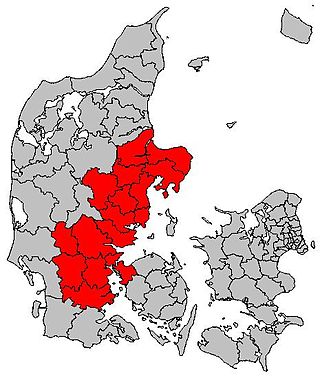
Aarhus Municipality, known as Århus Municipality until 2011, is a kommune in the Central Denmark Region, on the east coast of the Jutland peninsula in central Denmark.

Gellerup is a neighborhood of the Brabrand district in the city of Aarhus, Denmark. The neighborhood was formerly a suburb that has now completely merged with the city and it is characterized by several natural attractions, detached house sectors, highrise apartments and an industrial park.

Beder is a town with a population of 4,372 in Jutland in Denmark. Some consider Beder & the neighbouring town of Malling as one urban area. DST has since 2012 considered the towns one urban area making it the 84th largest in Denmark with a total population of 8,898 in 2020.

Randers is a city in Randers Municipality, Central Denmark Region on the Jutland peninsula. It is Denmark's sixth-largest city, with a population of 64,057. Randers is the municipality's main town and the site of its municipal council. By road it is 38.5 kilometres (23.9 mi) north of Aarhus, 43.8 kilometres (27.2 mi) east of Viborg, and 224 kilometres (139 mi) northwest of Copenhagen.

Malling is a village in Denmark, located about 12 km (7.5 mi) south of Aarhus. It has a population of 6,194 (Jan 1, 2020).
East Jutland metropolitan area is a potential metropolitan area in Jutland and Funen, Denmark. Aarhus is the most populated city in the region.

Aarhus Botanical Gardens is a botanical garden in Aarhus, Denmark. It is located north of the Old Town open-air village museum and was founded in 1875. Nowadays it covers an area of 21.5 hectares, with 5 hectares for the Old Town.

Næstved is a town in the municipality of the same name, located in the southern part of the island of Zealand in Denmark.

Marselisborg Forests, or simply Marselisborg Forest, is a 550 hectares forest to the south of Aarhus City in the Kingdom of Denmark. Many present day sources now includes the forest of Fløjstrup, as part of the Marselisborg Forests, upping the total area with another 200 hectares. Marselisborg Forests runs along the coastline of the Aarhus Bay in a hilly terrain with steep slopes and deep gullies, especially at the shoreline. There are many traces of prehistoric activities here and the landscape have been covered by woodlands for thousands of years.

Nørre Stenbro is a small neighborhood in the city of Aarhus, Denmark home to some 3,000 residents. The neighborhood is part of the Aarhus C district and borders the neighborhoods of Indre By south and west, Aarhus Docklands in the east and Trøjborg north. The residential area of Nørre Stenbro is delimited by the streets Nørre Boulevard, Østboulevarden, Østbanetorvet, Kystvejen, Nørreport and Nørrebrogade, but the large Nordre Cemetery and the smaller residential quarter of Skovvejskvarteret is also part of the same registration.

Beder-Malling is a town in Aarhus Municipality, Central Denmark Region in Denmark, with a population of 9,228. Beder-Malling is situated South-east of Mårslet and 6 kilometers South of Aarhus. Beder-Malling is a new town formed when the towns of Beder and Malling merged into one conurbation in the 2010s and it officially became one urban area.
Aarhus Municipality is divided in many different ways, often on layered levels. Politically it is a part of the multi-member constituency Østjyllands Storkreds which covers the eastern coast of East Jutland from Randers to Vejle Fjord. Aarhus Municipality itself is divided in 4 folketing constituencies, Århus Sydkredsen, Århus Vestkredsen, Århus Nordkredsen, Århus Østkredsen, which are again divided in a total of 45 wards, each with one polling station. The diocese of Aarhus is divided in a number of deaneries of which 4 resides in Aarhus Municipality with a total of 58 parishes. Administratively Aarhus Municipality operates with 25 districts or local communities (Lokalsamfund) which can be amalgamations of parishes, neighborhoods or former and present towns. In addition there are 28 postal districts within the municipality, some of which are colloquially used to denote areas and neighborhoods in the city of Aarhus. The urban area and immediate suburbs of the city of Aarhus are divided in the postal (P.D.) districts Aarhus C, Aarhus N, Aarhus V, Viby J, Højbjerg, Brabrand and Risskov.
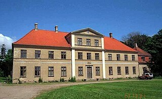
Vilhelmsborg is the National Equestrian Centre of Denmark and a listed building in Aarhus Municipality. The main manor building was completed in 1842 and was listed by the Danish Heritage Agency on 3 March 1945. The manor lies 10 km. south of Aarhus, by Beder-Malling in Mårslet Parish, and is today owned by Aarhus Municipality along with 288 hectares of adjoining land.

The Danish National Exhibition of 1909 or The National Exhibition in Aarhus 1909 was an industry, crafts and culture exhibition held in Aarhus, Denmark in 1909 from 18 May to 3 October. The exhibition displayed some 1850 individual works by architects, artists, craftsmen and businesses and attracted 650.000 visitors. The project was a large undertaking for the city with long-lasting effects on cultural institutions and short-term economic problems. The exhibition fairgrounds was named The white City based on the architectural expression chosen by the leading architect Anton Rosen.

Aarhus County Hospital, or Aarhus Sygehus, Tage-Hansens Gade, was a hospital in Aarhus for 136 years, from 1882 to 2018. The hospital became a part of Aarhus University Hospital in 2011 in an administrative merger. In 2018, all hospital functions at Aarhus County Hospital were relocated to The New University Hospital (DNU) in Skejby in northern Aarhus.

The architecture of Aarhus comprises numerous architectural styles and works from the Middle Ages to present-day. Aarhus has a well-preserved medieval city center with the oldest dwellings dating back to the mid-1500s and some ecclesiastical structures such as St. Clemen's Cathedral and numerous smaller churches that can be traced back to the 1100s. The industrialization of the 19th and 20th centuries left distinctive industrial structures, important National romantic works and some of the best examples of Functionalist architecture in the country. The history of the city as a Viking fort is evidenced in the street layout of the Latin Quarter, the wider Indre By neighborhood testifies to its later role as a Market town and center of commerce while the Frederiksbjerg, Trøjborg and Marselisborg districts showcase the first cohesive urban planning efforts of the early 20th century.
Giber Å is a 12 kilometres (7.5 mi) long stream in Aarhus Municipality.
