Ormslev

Last updated
Ormslev
Town
Ormslev Denmark center.JPG
Ormslev
Ormslev-placering-relativ-til-aarhus.jpeg
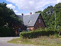
Aarhus Municipality Ormslev main street
Country Kingdom of Denmark
Regions of Denmark Central Denmark Region
Municipality Aarhus Municipality
Parish Ormslev Sogn
Population
 (2023)
  Total370
Postal code
8260 Viby J

Ormslev is a small village in Aarhus Municipality, Central Denmark Region in Denmark with a population of 370 (1 January 2023). [1]

Contents

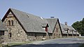
Ormslev is located 11 kilometres (6.8 mi) west of Aarhus city, between the settlements of Stavtrup (4 km (2.5 mi) east), Hasselager (4 km (2.5 mi) southeast) and Harlev (8 km (5.0 mi) west), on the southern slopes of the broad and flat Aarhus Ådal river valley, overlooking the Brabrand Lake and Aarhus River.

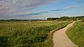
The lake and natural site of Årslev Engsø is located 2 kilometres (1.2 mi) northeast of Ormslev, including the historic manor of Constantinsborg. Route E45 passes by immediately west of Ormslev. Further west, about 4 kilometres (2.5 mi), is Aarhus Aadal Golf Club.

History

The church in Ormslev is probably very old, but a large part of it is later additions and the whole church was thoroughly reconstructed in 1739.

The area around Ormslev has been cultivated as farmland a long way back, as part of the historic and influential manor of Constantinsborg. Constantinsborg has been a manor for the nobility from at least the 15th century and is also an important agricultural producer today. From 1902 to 1956 the settlement of Ormslev became a railway town along the now abandoned Hammelbanen rail road line, and the village attracted some industry, including a grain mill, a dairy and some craftsmen. Half a kilometre southwest, marl was mined and transported by rail and the local farmers sent off their vegetables to market. Beginning in the 1930s, however, the small industrious village saw a decline and the rail road line was later abandoned altogether. The former train station, situated about half a kilometre northwest of the village on a lower elevation, has since been preserved and restored.

Related Research Articles

<span class="mw-page-title-main">Aarhus</span> City in Central Denmark Region, Denmark

Aarhus is the second-largest city in Denmark and the seat of Aarhus Municipality. It is located on the eastern shore of Jutland in the Kattegat sea and approximately 187 kilometres (116 mi) northwest of Copenhagen.

<span class="mw-page-title-main">Skejby</span> Neighborhood in Aarhus Municipality, Central Denmark Region, Kingdom of Denmark

Skejby is a neighbourhood and former village in Aarhus, Denmark. The neighbourhood is part of the city district Aarhus N.

<span class="mw-page-title-main">Brabrand</span> Postal district in Central Denmark Region, Kingdom of Denmark

Brabrand is a postal district of Aarhus Municipality, Denmark. South of Brabrand, in the Aarhus river-valley, is the largest recreational area of Aarhus Municipality, comprising the Brabrand Lake and the meadow-lake of Årslev, with surrounding natural sites.

<span class="mw-page-title-main">Odder Municipality</span> Municipality in Central Denmark, Denmark

Odder Municipality is a municipality in the Central Denmark Region on the east coast of the Jutland peninsula in Central Denmark south of Aarhus. It is a part of the greater Aarhus area. The municipality covers an area of 225.04 km², including the islands of Alrø and Tunø. It borders Aarhus Municipality to the north, Skanderborg Municipality to the north-west and Horsens Municipality to the west. It also connects to Hedensted Municipality across Horsens Fjord to the south, and connects to Samsø Municipality through a ferry route.

<span class="mw-page-title-main">Lystrup</span> Town in Region Midtjylland, Denmark

Lystrup is a suburb to Aarhus, Denmark. It is located 10 km north of Aarhus city centre, west of Egå and the Bay of Aarhus. It had a population of 10,213, and is the second most populous urban area of Aarhus Municipality.

<span class="mw-page-title-main">Malling, Denmark</span> Village in Midtjylland, Denmark

Malling is a village in Denmark, located about 12 km (7.5 mi) south of Aarhus. It has a population of 6,194 (Jan 1, 2020).

<span class="mw-page-title-main">Egå</span> Neighborhood in Aarhus Municipality, Central Denmark Region, Kingdom of Denmark

Egå is a both a suburban district and a stream in the Municipality of Aarhus in Denmark.

<span class="mw-page-title-main">Harlev</span> Town in Region Midtjylland, Denmark

Harlev is a former railway town in Aarhus Municipality in Denmark, with a population of 3,990 as of 1 January 2023. It is a suburb only 13 kilometres west of central Aarhus and is located at the Danish national road 15.

<span class="mw-page-title-main">Grenaa</span> Place in Central Denmark Region, Denmark

Grenaa is a Danish town and seaport on the east coast of the Jutlandic peninsula. Tourism, education and commerce are important sectors in the economy of Grenaa. It is the only larger town on Djursland. Grenaa is the municipal seat, and the largest town, in Norddjurs Municipality, which covers the northern half of Djursland.

<span class="mw-page-title-main">Aarhus (river)</span> River in Denmark

Aarhus River is a 40-kilometre (25 mi) long river or stream, in eastern Jutland, Denmark.

<span class="mw-page-title-main">Mollerup Skov</span>

Mollerup Skov is a 97 hectare relatively new forest situated in the northern outskirts of the city of Aarhus, Denmark. In the neighbourhood of Vejlby and Skejby between Skejbyvej, Langengevej and Skejby Nordlandsvej to be precise.

<span class="mw-page-title-main">Egå Engsø</span> Recreated lake and wet meadow in Midtjylland region

Egå Engsø is an artificial lake and wetland site located in the north of the town of Aarhus between Vejlby, Risskov and Lystrup. Engsø means 'meadow lake' and Egå means 'oak stream', referring to the stream that drains the lake into the Aarhus bay. The lake area is bordered by the Djursland motorway to the north and the Aarhus-Grenaa railway and the municipal heating pipes from Studstrup Power Station to the south and west.

<span class="mw-page-title-main">Brabrand Lake</span> Lake in Braband, Denmark

Brabrand Lake is a lake in the district of Brabrand (Gellerup), west of Aarhus city, Denmark. The Aarhus River passes through Brabrand Lake and it is possible to canoe all the way to the inner city from here. The lake is oblong-shaped.

<span class="mw-page-title-main">Constantin Marselis</span>

Constantin Marselis, or Constantijn Marselis, was a nobleman of the wealthy Dutch Marselis family.

<span class="mw-page-title-main">Borum</span> Town in Central Denmark Region, Kingdom of Denmark

Borum is a village in Aarhus Municipality, Central Denmark Region in Denmark. Borum is situated 2.5 kilometres south of Sabro and 3 kilometres west of the Aarhus suburb of Tilst and has a population of 306. About 2 kilometres west of Borum is the village of Herskind.

The following is a timeline of the history of the city of Aarhus, a city in central Denmark.

<span class="mw-page-title-main">Tranbjerg Church</span> Church in Denmark, Denmark

Tranbjerg Church is a church in Aarhus, Denmark, situated in the suburb Tranbjerg 9 kilometers south-west of Aarhus city center on the old country road between Aarhus and Horsens. Tranbjerg Church is from the 1100s, erected as a typical Danish Romanesque village church. Later additions in the 15th century added a Gothic tower and porch. Tranbjerg Church is the only church in Tranbjerg pastorate and Parish with 7.414 members of the Church of Denmark living in Tranbjerg Parish on 1 January 2016. Tranbjerg Church is devoted to St. Ursula and the 11.000 virgin handmaidens.

<span class="mw-page-title-main">Constantinsborg</span> Building in Aarhus Municipality, Denmark

Constantinsborg is a manor in Aarhus Municipality, Denmark which has existed since at least 1400. It is situated on the southern shore of Årslev Engsø, a newly created nature reserve and shallow lake extension of Brabrand Lake, in Viby J 10 km. south-west of Aarhus. The manor and estate are privately owned today and ran as a farm. Constantinsborg was originally known as Stadsgaard but was later renamed after Constantin Marselis who owned the estate in the 1600s. In the 1800s the Pontoppidan family owned the estate and came to have a large impact on Danish agriculture and the transformation of the Jutland moors into agricultural land. The current main manor building was constructed in the early 1800s while adjoining farm buildings date back to 1870 and the 20th century.

<span class="mw-page-title-main">Marienlyst Park</span>

Marienlyst Park is a public park in Hasle in the Aarhus V district, north-west Aarhus, Denmark. The park is situated west of the Herredsvang neighborhood along the street Fjældevænget Busvej to the south and Brendstrup Forest to the west. Marienlyst Park is one of the largest parks in Aarhus and features both landscaped lawns and artificial forested hills. Facilities include an amphitheatre, soccer fields, playgrounds and a 6-hole golf course. Marienlyst Park was established in connection with the development of western Hasle in the 1970s and today forms part of a green corridor extending from Vestereng to Brabrand Lake. The park is owned by Aarhus Municipality and is managed by the municipal department Natur og Miljø. Marienlyst Park can be rented for public events.

<span class="mw-page-title-main">Sønder Aarslev Church</span> Church in Aarhus, Denmark

Sønder Aarslev Church is a church located in Årslev, a small village-suburb in the western parts of Aarhus, Denmark. Årslev is situated in the Brabrand district, west of Aarhus city center. It is the church of Sønder Årslev Parish within the Church of Denmark and serves a parish population of 993 (2016). The church has an adjoining cemetery and the painter Jens Hansen-Aarslev (1847–1928) is buried there.

References

  1. BY3: Population 1. January, by urban areas The Mobile Statbank from Statistics Denmark

Sources

56°07′34″N10°03′37″E / 56.126°N 10.0604°E / 56.126; 10.0604