Borum | |
---|---|
Town | |
Country | Kingdom of Denmark |
Regions of Denmark | Central Denmark Region |
Municipality | Aarhus Municipality |
Parish | Borum Sogn |
Population (2024) | |
• Total | 308 |
Postal code | 8471 Sabro |
Borum is a village in Aarhus Municipality, Central Denmark Region in Denmark. Borum is situated 2.5 kilometres south of Sabro and 3 kilometres west of the Aarhus suburb of Tilst and has a population of 308 (1 January 2024). [1] About 2 kilometres west of Borum is the village of Herskind.
The village has an active community centered on the village hall, with amateur theatre, film club, choir, cooking, gymnastics, markets, etc.. Just south of Borum is the stream of Lyngbygård Å. The stream feeds Årslev Engsø and the Aarhus River and part of the river valley has recently been environmentally restored and reconstructed, with nature paths and trails. [2]
Borum church is placed on an elevation in the south west, overlooking the village. The older Romanesque parts of the small church is built from granite ashlar. There are several stone carved decorations and church frescos in the church. A 43 x 32 cm grey granite stone with a chiselled sun cross from the Bronze Age was discovered in the 1890s, when an associated stone dyke was dismantled. It has been in possession of the National Museum of Denmark since 1902.
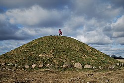
North west of the village, towards the lake of Lading Sø, is an elevated plateau overlooking the surrounding landscape, with remains of several Bronze Age burial mounds (tumuli). The most famous is Borum Eshøj, containing 3 remarkably preserved oak coffins, with the skeletons of 2 men and a woman, wearing intact clothing, daggers, combs and other grave goods, from the 14th century BC (Nordic Bronze Age). It is formerly one of the largest long barrows in Denmark. First explored in the 1870s, it is now a protected cultural heritage site. There is also has a Bronze Age settlement with some replica houses. [3]
A dolmen or portal tomb is a type of single-chamber megalithic tomb, usually consisting of two or more upright megaliths supporting a large flat horizontal capstone or "table". Most date from the Late Neolithic period and were sometimes covered with earth or smaller stones to form a tumulus. Small pad-stones may be wedged between the cap and supporting stones to achieve a level appearance. In many instances, the covering has eroded away, leaving only the stone "skeleton".
Skanderborg is a town in Skanderborg Municipality, Denmark. It is situated on the north and north eastern brinks of Skanderborg Lake and there are several smaller ponds and bodies of water within the city itself, like Lillesø, Sortesø, Døj Sø and the swampy boglands of Eskebæk Mose. Just north of the town on the other side of Expressway E45, is the archaeologically important Illerup Ådal. Over time, the town has grown into a suburb of Aarhus to the north east, connected by the urban areas of Stilling, Hørning and Hasselager.
Skejby is a neighbourhood and former village in Aarhus, Denmark. The neighbourhood is part of the city district Aarhus N.
The Nordic Bronze Age is a period of Scandinavian prehistory from c. 2000/1750–500 BC.
Moesgaard Museum (MOMU) is a Danish regional museum dedicated to archaeology and ethnography. It is located in Beder, a suburb of Aarhus, Denmark.
Lisbjerg is a village and suburb 7 km north of the city center of Aarhus, Denmark. Lisbjerg has a population of 1,519.
Sabro is a suburb of Aarhus in Denmark. Its population is 3,378. It is located in the west of Aarhus Municipality, approximately 13 kilometres (8.1 mi) from central Aarhus.
Grenaa is a Danish town and seaport on the east coast of the Jutlandic peninsula. Tourism, education and commerce are important sectors in the economy of Grenaa. It is the only larger town on Djursland. Grenaa is the municipal seat, and the largest town, in Norddjurs Municipality, which covers the northern half of Djursland.
Aarhus River is a 40-kilometre (25 mi) long river, in eastern Jutland, Denmark.
Østerlars is a village in the northeast of the Danish island of Bornholm, 6 kilometres (3.7 mi) south of Gudhjem and 5 kilometres (3.1 mi) northwest of Østermarie. It is best known for its round church, the largest on the island. 1. January 2024 it had a population of 267.
Brabrand Lake is a lake in the district of Brabrand (Gellerup), west of Aarhus city, Denmark. The Aarhus River passes through Brabrand Lake and it is possible to canoe all the way to the inner city from here. The lake is oblong-shaped.
Haldum is a village within the Haldum parish of the Favrskov municipality of mid-Jutland, Denmark, 20 km northwest of Aarhus. The town is home to the medieval-era Haldum Church. In 2004, Haldum Church became known as an archaeological site when the Moesgård Museum conducted excavations in the area surrounding the churchyard, which yielded notable Viking Age and Early Medieval period findings.
Ormslev is a small village in Aarhus Municipality, Central Denmark Region in Denmark with a population of 362.
Beder-Malling is a town in Aarhus Municipality, Central Denmark Region in Denmark, with a population of 9,395. Beder-Malling is situated South-east of Mårslet and 6 kilometers South of Aarhus. Beder-Malling is a new town formed when the towns of Beder and Malling merged into one conurbation in the 2010s and it officially became one urban area.
Rådhusparken is a public park in central Aarhus, Denmark. The park is situated by the City Hall in the Indre By neighborhood of Midtbyen, between the streets Frederiks Allé to the west and Park Allé to the east. The park lies within a scenic semi-circle of some of the more important cultural and political institutions in the city; the Concert Hall, the ARoS Art Museum, Vester Allés Kaserne and the city hall. The City Hall Park was listed along with the adjacent city hall on 10 March 1995.
Brabrand Church is a church located in Brabrand Parish in Aarhus, Denmark. The church is situated in the neighbourhood Brabrand by Brabrand Lake, west of Midtbyen. The church was originally devoted to St. Martin but is today a parish church in the Church of Denmark, serving a parish population of 6.962 (2015). The Brabrand Church pastorate is shared with the South Aarslev Church to the west. The resistance fighter Alf Tolboe Jensen, executed during the Second World War, is interred in the church cemetery.
Åby Church is a church located in Åby Parish in Aarhus, Denmark. The church is situated in the neighbourhood Åbyhøj, west of Midtbyen. The church is today a parish church in the Church of Denmark, serving a parish population of 10.925 (2015). The Åby Church pastorate is shared with the Åbyhøj Church to the north.
The architecture of Aarhus comprises numerous architectural styles and works from the Middle Ages to present-day. Aarhus has a well-preserved medieval city center with the oldest dwellings dating back to the mid-1500s and some ecclesiastical structures such as St. Clemen's Cathedral and numerous smaller churches that can be traced back to the 1100s. The industrialization of the 19th and 20th centuries left distinctive industrial structures, important National romantic works and some of the best examples of Functionalist architecture in the country. The history of the city as a Viking fort is evidenced in the street layout of the Latin Quarter, the wider Indre By neighborhood testifies to its later role as a Market town and center of commerce while the Frederiksbjerg, Trøjborg and Marselisborg districts showcase the first cohesive urban planning efforts of the early 20th century.
Geding Lake is a lake west of the Aarhus suburb of Tilst in Aarhus Municipality, Denmark. The stream Egå and the Egå river valley begins here. The lake is bounded by the Aarhus-Randers Rail Line to the west.
The Aarhus Runestones or Ålum Runestones are six Viking Age runestones which were discovered in and around the city of Aarhus, Denmark. The stones are officially titled Aarhus 1 through 6 and they are all memorial stones created in memory or honor of a person. All six stones are kept and displayed at Moesgård Museum and one of the stones is known as the Aarhus Stone or Mask Stone and features the carving of a mask which has become the official symbol of Moesgård Museum.
56°06′42″N10°00′15″E / 56.1118°N 10.0041°E