List
| Canal | Place | Location | Map | Status | Endpoints | Notes | |
|---|---|---|---|---|---|---|---|
| Grand Canal | Chinese subcontinent | 34°41′38″N112°28′6″E / 34.69389°N 112.46833°E |  |
|
| Bypassing the eastern coast of China, it provides a stable pirate-free wave-free channel for ship transport and water transport, crossing across the North China continental block. | |
| Rhine–Main–Danube Canal | European continent | 49°11′30″N11°15′3″E / 49.19167°N 11.25083°E |  |
|
| Channelizing the Rhine, the Main and the Danube, and connecting with a canal crossing the European Continental Divide, it traverses Europe. When combined with the Marne–Rhine Canal, it connects to the English Channel. With the addition of the proposed Danube–Oder Canal, the waterway system would also access the Baltic Sea. | |
| Saint Lawrence Seaway and Great Lakes Waterway | Eastern North America | 43°42′N77°54′W / 43.7°N 77.9°W |  |
|
| Following the route of the Saint Lawrence River, it allows access to the centre of the continent from the ocean by shipping. When combined with the New York State Canal System, it has a second access to the ocean at Long Island Sound / Hudson Estuary, turning New England into a virtual island. When combined with the Illinois Waterway, it can reach the Gulf of Mexico from the Great Lakes, turning the entire East Coast and Midwest of the United States into a virtual island. | |
| Mississippi River System | Central United States | In-operation |
| Channelizing the Mississippi River and major tributaries/distributaries, it accesses central North America. With the Saint Lawrence Seaway it reaches the Gulf of Saint Lawrence, and turns the Midwest and East Coast of the United States into a virtual island. | |||
| Intracoastal Waterway | East Coast and South Coast of North America | In-operation |
| Following the coastline of North America, wrapping all the way around the coast of the United States, a series of canals, channelized waters, navigable sheltered natural waters, allow protection from the open ocean. | |||
| Unified Deep Water System of European Russia | Russia |  | In-operation |
| Traversing across European Russia, the shipping waterway accesses the Atlantic and Arctic Ocean basins, and combined with the Suez Canal, accesses the Indian Ocean as well. | ||
| Eurasia Canal (Caspian Canal) | Caucasus | Proposed |
| Connecting the Caspian and the Black Seas, it would complete the Manych Ship Canal and Volga–Don Canal to fully connect the two seas with a shipping route. | |||
| Iranrud (Caspian Canal) | Iran | 35°41′N51°25′E / 35.683°N 51.417°E | 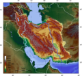 | Proposed |
| Russian plan for independence from the Bosphorus, Straits of Gibraltar, Suez Canal; by digging a canal to connect to the Indian Ocean from the Caspian Sea. through the Iranian Plateau and Iran; needing to cross mountains over 1,600 m (5,200 ft) high and being over 1,400 km (870 mi) long. | |
| Canal des Deux Mers | France | In-operation |
| The Canal des Deux Mers (English: Two Seas Canal) has been used to describe two different but similar things since the 1660s. In some cases, it describes the entire path from the Atlantic to the Mediterranean, including two canals, the Canal du Midi and the Canal Latéral de la Garonne. In others it is used interchangeably with the Canal du Midi in particular. | |||