Lists of waterways

Last updated

Estuary of Klamath River in Redwood National and State Parks, California Klamath river estuary.jpg
Estuary of Klamath River in Redwood National and State Parks, California

This article is a collection of lists of natural (rivers, estuaries, and straits) and artificial (reservoirs, canals and locks) waterways.

Contents

Waterways lists

Natural waterways

Artificial waterways

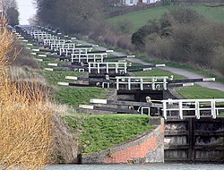
The flight of 16 consecutive locks at Caen Hill on the Kennet and Avon Canal, Wiltshire, England Caen.hill.locks.in.devizes.arp.jpg
The flight of 16 consecutive locks at Caen Hill on the Kennet and Avon Canal, Wiltshire, England

Canals

Others

The world's largest reservoir - Lake Volta, Ghana Volta lake.jpg
The world's largest reservoir - Lake Volta, Ghana

Organizations about waterways

See also

Related Research Articles

Canal Man-made channel for water

Canals or artificial waterways are waterways or engineered channels built for drainage management or for conveyancing water transport vehicles. They carry free, calm surface flow under atmospheric pressure, and can be thought of as artificial rivers.

Waterways in the United Kingdom

Water transport played a vital role in the UK's industrial development. The beginning of the 19th century saw a move from roads to waterways,.

River Avon, Warwickshire River in central England

The River Avon in central England flows generally southwestwards and is a major left-bank tributary of the River Severn, of which it is the easternmost. It is also known as the Warwickshire Avon or Shakespeare's Avon, to distinguish it from several other rivers of the same name in the United Kingdom.

<span class="mw-page-title-main">History of the British canal system</span> Building, use, decline and restoration of artificial waterways in the United Kingdom

The canal network of the United Kingdom played a vital role in the Industrial Revolution. The UK was the first country to develop a nationwide canal network which, at its peak, expanded to nearly 4,000 miles in length. The canals allowed raw materials to be transported to a place of manufacture, and finished goods to be transported to consumers, more quickly and cheaply than by a land based route. The canal network was extensive and included feats of civil engineering such as the Anderton Boat Lift, the Manchester Ship Canal, the Worsley Navigable Levels and the Pontcysyllte Aqueduct.

Black Warrior River River in Alabama, United States

The Black Warrior River is a waterway in west-central Alabama in the southeastern United States. The river rises in the extreme southern edges of the Appalachian Highlands and flows 178 miles (286 km) to the Tombigbee River, of which the Black Warrior is the primary tributary. The river is named after the Mississippian paramount chief Tuskaloosa, whose name was Muskogean for 'Black Warrior'. The Black Warrior is impounded along nearly its entire course by a series of locks and dams to form a chain of reservoirs that not only provide a path for an inland waterway, but also yield hydroelectric power, drinking water, and industrial water.

<span class="mw-page-title-main">Canals of the United Kingdom</span>

The canals of the United Kingdom are a major part of the network of inland waterways in the United Kingdom. They have a varied history, from use for irrigation and transport, through becoming the focus of the Industrial Revolution, to today's role of recreational boating. Despite a period of abandonment, today the canal system in the United Kingdom is again increasing in use, with abandoned and derelict canals being reopened, and the construction of some new routes. Canals in England and Wales are maintained by navigation authorities. The biggest navigation authorities are the Canal & River Trust and the Environment Agency, but other canals are managed by companies, local authorities or charitable trusts.

<span class="mw-page-title-main">Okeechobee Waterway</span> Canal in Florida, United States of America

The Okeechobee Waterway or Okeechobee Canal is a relatively shallow artificial waterway in the United States, stretching across Florida from Fort Myers on the west coast to Stuart on Florida's east coast. The waterway can support tows such as barges or private vessels up to 50 feet wide x 250 feet long which draw less than 10 feet, as parts of the system, especially the locks may have low water depths of just ten feet. The system of channels runs through Lake Okeechobee and consists of the Caloosahatchee River to the west of the lake and the St. Lucie Canal east of the lake.

McAlpine Locks and Dam Dam in Louisville, Kentucky

The McAlpine Locks and Dam are a set of locks and a hydroelectric dam at the Falls of the Ohio River at Louisville, Kentucky. They are located at mile point 606.8, and control a 72.9 miles (117.3 km) long navigation pool. The locks and their associated canal were the first major engineering project on the Ohio River, completed in 1830 as the Louisville and Portland Canal, designed to allow shipping traffic to navigate through the Falls of the Ohio.

Tsimlyansk Reservoir Artificial lake on the Don river, Russia

Tsimlyansk Reservoir or Tsimlyanskoye Reservoir is an artificial lake on the Don River in the territories of Rostov and Volgograd Oblasts at 47°50′N42°50′E. Completed in 1952, the reservoir is one of the largest in Russia, providing power and irrigation to the Rostov and Volgograd regions. Crops grown around the lake include wheat, rice, cotton, maize, alfalfa, fruit, grapes, and vegetables.

Wheeler Dam Dam in Alabama, United States

Wheeler Dam is a hydroelectric dam on the Tennessee River between Lauderdale County and Lawrence County in Alabama. It is one of nine dams on the river owned and operated by the Tennessee Valley Authority, which built the dam in the mid-1930s as part of a New Deal-era initiative to improve navigation on the river and bring flood control and economic development to the region. The dam impounds the Wheeler Lake of 67,070 acres (27,140 ha) and its tailwaters feed into Wilson Lake.

Pickwick Landing Dam Dam in Tennessee, United States

Pickwick Landing Dam is a hydroelectric dam on the Tennessee River in Hardin County, in the U.S. state of Tennessee. The dam is one of nine dams on the river owned and operated by the Tennessee Valley Authority, which built the dam in the 1930s as part of a New Deal-era initiative to create a continuous navigation channel between the river's mouth and Knoxville, and bring economic development to the area. The dam impounds the 43,100-acre (17,400 ha) Pickwick Lake and its tailwaters are part of Kentucky Lake.

Nantes–Brest canal

The Nantes–Brest canal is a French canal which links the two seaports of Nantes and Brest through inland Brittany. It was built in the early 19th century, and its total length as built was 385 km with 238 locks.

<span class="mw-page-title-main">McClellan–Kerr Arkansas River Navigation System</span> Part of the United States inland waterway system

The McClellan–Kerr Arkansas River Navigation System (MKARNS) is part of the United States inland waterway system originating at the Tulsa Port of Catoosa and running southeast through Oklahoma and Arkansas to the Mississippi River. The total length of the system is 445 miles (716 km). It was named for two senators, Robert S. Kerr (D-OK) and John L. McClellan (D-AR), who pushed its authorizing legislation through Congress. The system officially opened on June 5, 1971. President Richard M. Nixon attended the opening ceremony. It is operated by the Army Corps of Engineers (USACE).

Bosley Reservoir Body of water

Bosley Reservoir is a large reservoir created to feed the Macclesfield Canal system, specifically the twelve Bosley locks. It is fed from the surrounding hills, including Bosley Cloud which rises to 1,125 feet.

A navigation authority is a company or statutory body which is concerned with the management of a navigable canal or river.

The River Medway in England flows for 70 miles (113 km) from Turners Hill, in West Sussex, through Tonbridge, Maidstone and the Medway Towns conurbation in Kent, to the River Thames at Sheerness, where it shares the latter's estuary. The Medway Navigation runs from the Leigh Barrier south of Tonbridge to Allington just north of Maidstone. It is 19 miles (31 km) in length. The Environment Agency is the navigation authority responsible for the navigation.

Voies navigables de France

Voies navigables de France is the French navigation authority responsible for the management of the majority of France's inland waterways network and the associated facilities—towpaths, commercial and leisure ports, lock-keeper's houses and other structures. VNF was established in 1991 and took over the responsibility for all waterways from the National Office of Navigation in 1993. It is a public body and is under the control of the Minister of Ecology, Energy, Sustainable Development and Territorial Development. The headquarters of VNF are in Béthune, Pas-de-Calais with local offices throughout France.

Longest rivers of the United Kingdom

This is a list of the longest rivers of the United Kingdom.