List of aqueducts

Last updated

This is a list of aqueducts.

Africa

Botswana

Egypt

Libya

South Africa

Sudan

Tunisia

Asia

Sri Lanka

China

India

Israel

Japan

Jordan

Kazakhstan

Taiwan

Turkmenistan

Australia and Oceania

Australia

New Zealand

The unique Tokaanu Tailrace Bridge, a combined road and water bridge crosses a power canal of the Tongariro Power Scheme in the North Island of New Zealand. State Highway 41 travels along the top of this bridge, with the Tokaanu Stream, an important trout spawning stream, running under the road surface.

Contents

Europe

Croatia

Cyprus

France

Pont du Gard seen from the river Gardon Pont du Gard 3.jpg
Pont du Gard seen from the river Gardon

Germany

Greece

Ireland

Italy

Malta

Montenegro

Netherlands

Flevoland

Friesland

Gelderland

North Holland

Overijssel

South Holland

Utrecht

Zeeland

North Macedonia

The Skopje Aqueduct Akvadukt, Skopje, 2014.jpg
The Skopje Aqueduct

Portugal

Russia

Spain

Les Ferreres Aqueduct Tarragona aquaduct 02.jpg
Les Ferreres Aqueduct

Sweden

Turkey

United Kingdom

North America

Canada

United States

Arizona

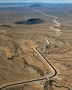
A canal of the Central Arizona Project Arizona cap canal.jpg
A canal of the Central Arizona Project

California

California Aqueduct and Delta-Mendota Canal Kluft-Photo-Aerial-I205-California-Aqueduct-Img 0038.jpg
California Aqueduct and Delta-Mendota Canal

Idaho

Indiana

Duck Creek Aquaduct, Metamora, Indiana

Massachusetts

New Mexico

New York

Puerto Rico

Texas

Washington, D.C.

Washington State

Mexico

Pastita Aqueduct, Guanajuato City Acueducto de Pastita, Guanajuato Capital, Guanajuato.jpg
Pastita Aqueduct, Guanajuato City

South America

Brazil

Colombia

Peru

Related Research Articles

<span class="mw-page-title-main">Leat</span> Artificial watercourse or aqueduct dug into the ground

A leat is the name, common in the south and west of England and in Wales, for an artificial watercourse or aqueduct dug into the ground, especially one supplying water to a watermill or its mill pond. Other common uses for leats include delivery of water for hydraulic mining and mineral concentration, for irrigation, to serve a dye works or other industrial plant, and provision of drinking water to a farm or household or as a catchment cut-off to improve the yield of a reservoir.

<span class="mw-page-title-main">Colorado River</span> Major river in the western United States and Mexico

The Colorado River is one of the principal rivers in the Southwestern United States and in northern Mexico. The 1,450-mile-long (2,330 km) river drains an expansive, arid watershed that encompasses parts of seven U.S. states and two Mexican states. The name Colorado derives from the Spanish language for "colored reddish" due to its heavy silt load. Starting in the central Rocky Mountains of Colorado, it flows generally southwest across the Colorado Plateau and through the Grand Canyon before reaching Lake Mead on the Arizona–Nevada border, where it turns south toward the international border. After entering Mexico, the Colorado approaches the mostly dry Colorado River Delta at the tip of the Gulf of California between Baja California and Sonora.

<span class="mw-page-title-main">Los Angeles Aqueduct</span> Water conveyance system in California, United States

The Los Angeles Aqueduct system, comprising the Los Angeles Aqueduct and the Second Los Angeles Aqueduct, is a water conveyance system, built and operated by the Los Angeles Department of Water and Power. The Owens Valley aqueduct was designed and built by the city's water department, at the time named The Bureau of Los Angeles Aqueduct, under the supervision of the department's Chief Engineer William Mulholland. The system delivers water from the Owens River in the Eastern Sierra Nevada Mountains to Los Angeles.

<span class="mw-page-title-main">Gila River</span> River in New Mexico and Arizona, United States

The Gila River is a 649-mile-long (1,044 km) tributary of the Colorado River flowing through New Mexico and Arizona in the United States. The river drains an arid watershed of nearly 60,000 square miles (160,000 km2) that lies mainly within the U.S., but also extends into northern Sonora, Mexico.

<span class="mw-page-title-main">California Aqueduct</span> Water supply project

The Governor Edmund G. Brown California Aqueduct is a system of canals, tunnels, and pipelines that conveys water collected from the Sierra Nevada Mountains and valleys of Northern and Central California to Southern California. Named after California Governor Edmund Gerald "Pat" Brown Sr., the over 400-mile (640 km) aqueduct is the principal feature of the California State Water Project.

<span class="mw-page-title-main">Colorado River Aqueduct</span> Water conveyance in Southern California

The Colorado River Aqueduct, or CRA, is a 242 mi (389 km) water conveyance in Southern California in the United States, operated by the Metropolitan Water District of Southern California (MWD). The aqueduct impounds water from the Colorado River at Lake Havasu on the California-Arizona border, west across the Mojave and Colorado deserts to the east side of the Santa Ana Mountains. It is one of the primary sources of drinking water for Southern California.

<span class="mw-page-title-main">All-American Canal</span> Aqueduct in southern California

The All-American Canal is an 82-mile (132 km) long aqueduct, located in southeastern California. It conveys water from the Colorado River into the Yuma Project, the Imperial Valley, and to nine cities. It is the Imperial Valley's only water source, and replaced the Alamo Canal, which was located mostly in Mexico. The Imperial Dam, about 30 miles (48 km) northeast of Yuma, Arizona on the Colorado River, diverts water into the All-American Canal, which runs to just west of Calexico, California before its last branch heads mostly north into the Imperial Valley. Smaller canals branching off the All-American Canal move water into the Yuma Valley and the Imperial Valley. These canal systems irrigate up to 630,000 acres (250,000 ha) of crop land and have made possible a greatly increased crop yield in this area, originally one of the driest on earth. It is the largest irrigation canal in the world, carrying a maximum of 26,155 cubic feet per second (740.6 m3/s). Agricultural runoff from the All-American Canal drains into the Salton Sea.

<span class="mw-page-title-main">California State Water Project</span> Flood control, energy production, and water conveyance infrastructure

The California State Water Project, commonly known as the SWP, is a state water management project in the U.S. state of California under the supervision of the California Department of Water Resources. The SWP is one of the largest public water and power utilities in the world, providing drinking water for more than 27 million people and generating an average of 6,500 GWh of hydroelectricity annually. However, as it is the largest single consumer of power in the state itself, it has a net usage of 5,100 GWh.

Water tunnels are tunnels used to transport water to areas with large populations or agriculture. They are frequently part of aqueducts. Some aqueducts, such as the Delaware Aqueduct are single long tunnels. In other cases, such as the San Jacinto tunnel on the Colorado River Aqueduct, water tunnels form parts of far longer aqueducts. In cases where the outflow of a water tunnel is into an existing stream or river flowing to the point of water use, the term aqueduct is less likely to be used, as with the Harold D. Roberts Tunnel from Dillon Reservoir to the North Fork South Platte River.

The Peripheral Canal was a series of proposals starting in the 1940s to divert water from California's Sacramento River, around the periphery of the San Joaquin-Sacramento River Delta, to uses farther south. The canal would have attempted to resolve a problem with the quality of water pumped south. Pumps create such a powerful suction that the boundary between freshwater to saltwater has shifted inland, negatively affecting the environment. The pumps have increased by 5 to 7 million acre-feet the amount of water exported each year to the Central Valley and Southern California. However, the peripheral canal as proposed would have reduced the overall freshwater flow into the Delta and move the freshwater-saltwater interface further inland, causing damage to Delta agriculture and ecosystems.

<span class="mw-page-title-main">Canal de Marseille</span>

The Canal de Marseille is a major source of drinking water for all of Marseille, the largest city in Provence, France. The canal along its main artery is 80 kilometres (50 mi) long but has additional 160 kilometres (99 mi) of minor arteries. Its construction lasted 15 years and was directed by the engineer Franz Mayor de Montricher; the canal opened on July 8, 1849.

<span class="mw-page-title-main">Interbasin transfer</span>

Interbasin transfer or transbasin diversion are terms used to describe man-made conveyance schemes which move water from one river basin where it is available, to another basin where water is less available or could be utilized better for human development. The purpose of such water resource engineering schemes can be to alleviate water shortages in the receiving basin, to generate electricity, or both. Rarely, as in the case of the Glory River which diverted water from the Tigris to Euphrates River in modern Iraq, interbasin transfers have been undertaken for political purposes. While ancient water supply examples exist, the first modern developments were undertaken in the 19th century in Australia, India and the United States, feeding large cities such as Denver and Los Angeles. Since the 20th century many more similar projects have followed in other countries, including Israel and China, and contributions to the Green Revolution in India and hydropower development in Canada.

<span class="mw-page-title-main">Pont d'Aël</span> Roman aqueduct in Aosta Valley, Italy

The Pont d'Aël is a Roman aqueduct located in a village of the same name in the comune of Aymavilles in Aosta Valley, northern Italy. It was built in the year 3BC for irrigation purposes and supplying water for the newly founded colony of Augusta Praetoria, which is now known as Aosta. The water was directed through a neighbouring valley 66 m above the floor of the Aosta valley, through a sophisticated system. The aqueduct is 6 km long in total. In addition to its unusual position, the construction, which was originally thought to be a three-story structure, shows more unique features such as a control corridor below the water line, as well as explicit private funding. Today, the water channel of the aqueduct serves as a public walking trail.

The Tongariro Power Scheme is a 360 MW hydroelectricity scheme in the central North Island of New Zealand. The scheme is currently operated by electricity generation company Genesis Energy.

<span class="mw-page-title-main">Klamath Diversion</span>

The Klamath Diversion was a federal water project proposed by the U.S. Bureau of Reclamation in the 1950s. It would have diverted the Klamath River in Northern California to the more arid central and southern parts of that state. It would relieve irrigation water demand and groundwater overdraft in the Central Valley and boost the water supply for Southern California. Through the latter it would allow for other Southwestern states—Arizona, Nevada, New Mexico and Utah—as well as Mexico to receive an increased share of the waters of the Colorado River.

<span class="mw-page-title-main">Aqueduct of the Gier</span>

The Aqueduct of the Gier is an ancient Roman aqueduct probably constructed in the 1st century AD to provide water for Lugdunum (Lyon), in what is now eastern France. It is the longest and best preserved of four Roman aqueducts that served the growing capital of the Roman province of Gallia Lugdunensis. It drew its water from the source of the Gier, a small tributary of the Rhone, on the slopes of Mont Pilat, 42 km (26 mi) south-west of Lyon.

<span class="mw-page-title-main">Course of the Colorado River</span> Route and confluences of the Colorado River in the United States and Mexico

The Colorado River is a major river of the western United States and northwest Mexico in North America. Its headwaters are in the Rocky Mountains where La Poudre Pass Lake is its source. Located in north central Colorado it flows southwest through the Colorado Plateau country of western Colorado, southeastern Utah and northwestern Arizona where it flows through the Grand Canyon. It turns south near Las Vegas, Nevada, forming the Arizona–Nevada border in Lake Mead and the Arizona–California border a few miles below Davis Dam between Laughlin, Nevada and Needles, California before entering Mexico in the Colorado Desert. Most of its waters are diverted into the Imperial Valley of Southern California. In Mexico its course forms the boundary between Sonora and Baja California before entering the Gulf of California. This article describes most of the major features along the river.

<span class="mw-page-title-main">Aqueduct (water supply)</span> Structure constructed to convey water

An aqueduct is a watercourse constructed to carry water from a source to a distribution point far away. In modern engineering, the term aqueduct is used for any system of pipes, ditches, canals, tunnels, and other structures used for this purpose. The term aqueduct also often refers specifically to a bridge carrying an artificial watercourse. Aqueducts were used in ancient Greece, ancient Egypt, and ancient Rome. The simplest aqueducts are small ditches cut into the earth. Much larger channels may be used in modern aqueducts. Aqueducts sometimes run for some or all of their path through tunnels constructed underground. Modern aqueducts may also use pipelines. Historically, agricultural societies have constructed aqueducts to irrigate crops and supply large cities with drinking water.

<span class="mw-page-title-main">Aqueduct (bridge)</span> Structure constructed to convey water

Aqueducts are bridges constructed to convey watercourses across gaps such as valleys or ravines. The term aqueduct may also be used to refer to the entire watercourse, as well as the bridge. Large navigable aqueducts are used as transport links for boats or ships. Aqueducts must span a crossing at the same level as the watercourses on each end. The word is derived from the Latin aqua ("water") and ducere, therefore meaning "to lead water". A modern version of an aqueduct is a pipeline bridge. They may take the form of tunnels, networks of surface channels and canals, covered clay pipes or monumental bridges.

<span class="mw-page-title-main">Irtysh–Karamay–Ürümqi Canal</span> Irrigation project

The Irtysh–Karamay–Ürümqi Canal, also known as the Project 635 Canal, is a system of water-transfer canals and reservoirs in the northern part of China's Xinjiang Uighur Autonomous Region. It transfers water from the Irtysh River into several dry endorheic basins of north-central Xinjiang, where it is used for irrigation and general use of the population and industries.

References

  1. "Archived copy". Archived from the original on 2014-10-10. Retrieved 2016-01-15.{{cite web}}: CS1 maint: archived copy as title (link)