Enfield was a town in Hampshire County, Massachusetts, United States. The town was lost as a result of the creation of the Quabbin Reservoir.

The Los Angeles Aqueduct system, comprising the Los Angeles Aqueduct and the Second Los Angeles Aqueduct, is a water conveyance system, built and operated by the Los Angeles Department of Water and Power. The Owens Valley aqueduct was designed and built by the city's water department, at the time named The Bureau of Los Angeles Aqueduct, under the supervision of the department's Chief Engineer William Mulholland. The system delivers water from the Owens River in the eastern Sierra Nevada mountains to Los Angeles.

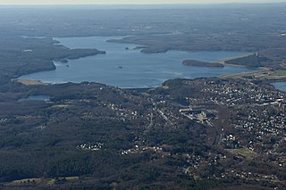
The Quabbin Reservoir is the largest inland body of water in Massachusetts, United States, and was built between 1930 and 1939. Along with the Wachusett Reservoir, it is the primary water supply for Boston, 65 miles (105 km) to the east, and 40 other cities and towns in Greater Boston. The Quabbin also supplies water to three towns west of the reservoir and acts as backup supply for three others. By 1989, it supplied water for 2.5 million people, about 40% of the state's population at the time. It has an aggregate capacity of 412 billion US gallons (1,560 GL) and an area of 38.6 square miles (99.9 km2).

The Governor Edmund G. Brown California Aqueduct is a system of canals, tunnels, and pipelines that conveys water collected from the Sierra Nevada and valleys of Northern and Central California to Southern California. Named after California Governor Edmund Gerald "Pat" Brown Sr., the over 400-mile (640 km) aqueduct is the principal feature of the California State Water Project.

The Massachusetts Water Resources Authority (MWRA) is a public authority in the Commonwealth of Massachusetts that provides wholesale drinking water and sewage services to 3.1 million people in sixty-one municipalities and more than 5,500 large industrial users in the eastern and central parts of the state, primarily in the Boston area.

Western Massachusetts, known colloquially as "western Mass," is a region in Massachusetts, one of the six U.S. states that make up the New England region of the United States. Western Massachusetts has diverse topography; 22 colleges and universities including UMass in Amherst, MA, with approximately 100,000 students; and such institutions as Tanglewood, the Springfield Armory, and Jacob's Pillow.
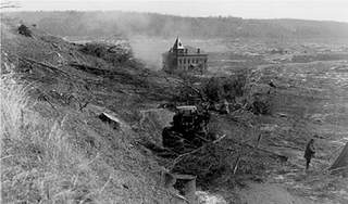
Prescott was a town in Hampshire County, Massachusetts, United States. It was incorporated in 1822 from portions of Pelham and New Salem, and was partially built on Equivalent Lands. It was named in honor of Colonel William Prescott, who commanded the American forces at the Battle of Bunker Hill. It was disincorporated on April 28, 1938, as part of the creation of the Quabbin Reservoir. It was the least populous of the four unincorporated towns, with barely 300 residents by 1900. Upon dissolution, portions of the town were annexed to the adjacent towns of New Salem and Petersham. The majority of the former town is still above water, and is known as the Prescott Peninsula. The public is not allowed on the peninsula except for an annual tour given by the Swift River Valley Historical Society, or for hikes conducted by the Society. None of the land is in Hampshire County any longer; the New Salem portion is in Franklin County; and the Petersham portion is in Worcester County.
The Wachusett Reservoir is the second largest body of water in the state of Massachusetts. It is located in central Massachusetts, northeast of Worcester. It is part of the water supply system for metropolitan Boston maintained by the Massachusetts Water Resources Authority (MWRA). It has an aggregate capacity of 65 billion US gallons (250,000,000 m3) and an area of almost 7 square miles (18 km2). Water from the reservoir flows to the covered Norumbega Storage Facility via the Cosgrove Tunnel and the MetroWest Water Supply Tunnel. The reservoir has a maximum depth of 120 feet (37 m) and a mean depth of 48 feet (15 m).
The Quabbin Aqueduct carries water from the Quabbin Reservoir to the Wachusett Reservoir. It is part of the Eastern Massachusetts public water supply system, maintained by the Massachusetts Water Resources Authority (MWRA). At 25 miles (40 km) in length, it is one of the longest aqueduct tunnels in the world.

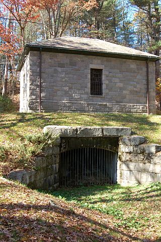
The Ware River Diversion is a dam on the Ware River. It is part of the Boston, Massachusetts public water supply system, maintained by the Massachusetts Water Resources Authority (MWRA). It is located in Worcester County in the town of Barre, close to its border with Oakham.

The Ware River is a 35.4-mile-long (57.0 km) river in central Massachusetts. It has two forks, its West Branch, which begins in Hubbardston, Massachusetts, and its East Branch, which begins in Westminster, Massachusetts. The Ware River flows southwest through the middle of the state, joins the Quaboag River at Three Rivers, Massachusetts, to form the Chicopee River on its way to the Connecticut River.

The Wachusett Aqueduct is a secondary aqueduct that carries water from the Wachusett Reservoir to the John J. Carroll Water Treatment Plant at Walnut Hill in Marlborough, Massachusetts. It is part of the public water supply system for the communities of Greater Boston that are served by the Massachusetts Water Resources Authority (MWRA), which manages the aqueduct. The aqueduct serves as a standby backup to the Cosgrove Tunnel.

The Weston Reservoir is part of the greater Boston water supply maintained by the Massachusetts Water Resources Authority. It is located in central Weston, with its principal public access point on Ash Street.

The Goodnough Dike is on the southeastern end of the Quabbin Reservoir, the largest water body in Massachusetts. It impounds the waters of Beaver Brook and therefore closes that exit to the Chicopee River Watershed. The Goodnough Dike is not as large as the Winsor Dam, but it is equally important as they both trap the waters of the Quabbin Reservoir. This dam is part of the metropolitan Boston's water supply, maintained by the Massachusetts Water Resources Authority.
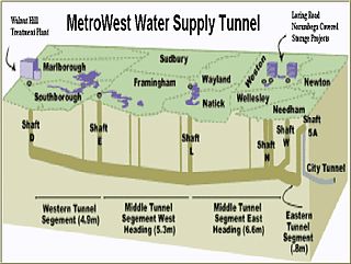
The MetroWest Water Supply Tunnel (MWWST) is an advanced underground aqueduct that supplies potable water to residents of much of Greater Boston. It is part of the Massachusetts Water Resources Authority (MWRA) water supply system, having entered operation in November 2003.

Chestnut Hill Reservoir is a reservoir located in the Chestnut Hill section of Boston, Massachusetts. It was created in 1870 on existing marshes and meadowland to supplement the city’s water needs. A 1.56 mile jogging loop abuts the reservoir. Chestnut Hill Reservoir was taken offline in 1978 as it was no longer needed for regular water supply distribution, but is maintained in emergency backup status. It is recognized today on the National Register of Historic Places and was designated as a Boston Landmark by the Boston Landmarks Commission in 1989.

The Chicopee River is an 18.0-mile-long (29.0 km) tributary of the Connecticut River in the Pioneer Valley, Massachusetts, known for fast-moving water and its extraordinarily large basin: the Connecticut River's largest tributary basin. The Chicopee River originates in a Palmer, Massachusetts village called Three Rivers as a confluence of the Ware, Quaboag and Swift rivers. It passes through Wilbraham, Ludlow, and the Indian Orchard neighborhood of Springfield.

Frank E. Winsor (1870-1939) was the chief engineer for the Boston Metropolitan District Water Supply Commission, now the Massachusetts Water Resources Authority, from 1926 until his death in 1939 and was closely involved in the design and construction of Winsor Dam and Goodnough Dike which were built by the Commission to create the Quabbin Reservoir in Massachusetts. Winsor Dam was named for him.

The Sudbury Reservoir is an emergency backup Boston metropolitan water reservoir in Massachusetts, located predominantly in Southborough and Marlborough, with small sections in Westborough and Framingham. It was created when the Sudbury Dam was constructed to impound the Stony Brook branch of the Sudbury River; no part of the reservoir lies in the town of Sudbury. Nearly 5,000 acres (2,000 ha) in the Sudbury Reservoir watershed are administered by the Massachusetts Department of Conservation and Recreation as a limited-access public recreation area.

