Carioca Aqueduct

Last updated
Carioca Aqueduct
At Rio de Janeiro 2019 129.jpg
Coordinates 22°54′45.34″S43°10′47.46″W / 22.9125944°S 43.1798500°W / -22.9125944; -43.1798500
Characteristics
Total length270 metres (890 ft)
Height64 metres (210 ft)
History
Construction start1718
Inaugurated1750
Location
Carioca Aqueduct
References
[1]

The Carioca Aqueduct (Portuguese : Aqueduto da Carioca), also known as Arcos da Lapa, is an aqueduct in the city of Rio de Janeiro, Brazil. The aqueduct was built in the middle of the 18th century to bring fresh water from the Carioca River to the population of the city. It is a typical example of colonial architecture and engineering.

Contents

The Carioca Aqueduct is located in the centre of the city, in the Lapa neighbourhood. Since the end of the 19th century the aqueduct serves as a bridge for the Santa Teresa Tramway that connects the city centre with the Santa Teresa neighbourhood uphill.

History

In the early history of Rio de Janeiro, the nucleus of the city was surrounded by swamps with water of bad quality, and fresh water had to be carried manually from streams located relatively far from the city. Since at least 1602 there had been plans to build a system of canals to bring water from the source of the Carioca river, located on Santa Teresa hill, to Rio de Janeiro. Colonial authorities attempted to build canals, but the construction was always hampered by technical and financial difficulties. By the end of the 17th century there were only a few hundred metres of canalisation completed.

The Carioca Aqueduct by painter Leandro Joaquim (c. 1790). Santa Teresa hill and its convent are seen to the left. The lagoon in the foreground was landfilled to build the Passeio Publico LeandroJoaquim-1790-Arcos.jpg
The Carioca Aqueduct by painter Leandro Joaquim (c. 1790). Santa Teresa hill and its convent are seen to the left. The lagoon in the foreground was landfilled to build the Passeio Público

After 1706, construction of the aqueduct was given a fresh impulse by authorities. During the rule of governor Aires de Saldanha (1719–1725) it was decided that the canals, which at the time reached the Campo da Ajuda (today's Cinelândia square), should reach the Santo Antônio square (today's Largo da Carioca), which was closer to the centre of the city. Construction of the first aqueduct was finished in 1723, and clean water flowed directly to a decorative Baroque fountain in Santo Antônio Square, to the relief of the people of Rio de Janeiro.

This first aqueduct was already in bad shape by 1744, when governor Gomes Freire de Andrade (1733–1763) ordered the building of a new, larger structure. The works were encharged to Portuguese military engineer José Fernandes Pinto Alpoim, who was inspired by similar structures in Portugal, like the Águas Livres Aqueduct in Lisbon. The aqueduct was inaugurated in 1750.

The most impressive feature of the aqueduct is the course that connects the hills of Santa Teresa and Santo Antônio, in today's Lapa neighbourhood. This segment of the aqueduct spans 270 metres and consists of two storeys of monumental arches - 42 in total - with a maximum height of 17.6 metres.

In colonial times, water from the Carioca Aqueduct reached several fountains scattered through Rio de Janeiro, including those in Santo Antônio Square, Ajuda Square (Cinelândia) and the Terreiro do Paço (today's Praça XV ). At the end of the 18th century, as the waters of the Carioca river were insufficient to feed the aqueduct, water from other streams were also diverted to its canals.

Tramway

The aqueduct was deactivated at the end of the 19th century, as new alternatives to supply water to Rio were developed. The structure was adapted in 1896 to serve as a viaduct for a tram line the Bonde de Santa Teresa (Santa Teresa Tramway) that transports passengers between the centre of Rio and the hilly Santa Teresa neighbourhood. The picturesque ride is popular among locals and tourists alike. The Santa Teresa bonde (or bondinho, meaning "little tram") is the only tram still in operation in Rio de Janeiro, although the 2016-opened Rio de Janeiro Light Rail system is similar to a tramway on some sections.[ citation needed ]

In the 1960s, several houses which had been built near the aqueduct were demolished, improving the visual impact of the monument.[ citation needed ]

In August 2011, an accident occurred when brakes apparently failed and left five people dead. [2] In response, all service was indefinitely suspended, but plans to rebuild the line and replace the old tramcars (with faux-vintage replicas) were subsequently approved. [3] Limited service on a portion of the line including across the former aqueduct began operating again in July 2015. [4]

Bonde Sta Tereza01.jpg
Panoramic view

Related Research Articles

<span class="mw-page-title-main">Rio de Janeiro</span> Second-most populous city in Brazil

Rio de Janeiro, or simply Rio, is the capital of the state of Rio de Janeiro. Rio de Janeiro is the second-most-populous city in Brazil and the sixth-most-populous city in the Americas. Notably, it is listed by the GaWC as a beta global city and part of Rio de Janeiro is designated as a World Heritage Site.

<span class="mw-page-title-main">Conservation and restoration of rail vehicles</span> Aims to preserve historic rail vehicles

Conservation and restoration of rail vehicles aims to preserve historic rail vehicles.

<span class="mw-page-title-main">Elvas</span> Municipality in Alentejo, Portugal

Elvas is a Portuguese municipality, former episcopal city and frontier fortress of easternmost central Portugal, located in the district of Portalegre in Alentejo. It is situated about 200 kilometres (120 mi) east of Lisbon, and about 8 kilometres (5.0 mi) west of the Spanish fortress of Badajoz, by the Madrid-Badajoz-Lisbon railway. The municipality population as of 2011 was 23,078, in an area of 631.29 square kilometres (243.74 sq mi). The city itself had a population of 16,640 as of 2011.

<span class="mw-page-title-main">Rio de Janeiro Metro</span> Rapid transit network serving Rio de Janeiro, Brazil

The Rio de Janeiro Metro, commonly referred to as just the Metrô is a rapid transit network that serves the city of Rio de Janeiro, Brazil. The Metrô was inaugurated on 5 March 1979, and consisted of five stations operating on a single line. The system currently covers a total of 58 kilometres (36 mi), serving 41 stations, divided into three lines: Line 1 ; Line 2, which together travel over a shared stretch of line that covers 10 stations of an approximate distance of 5 kilometres (3.1 mi); and Line 4. Metrô Rio has the second highest passenger volume of the metro systems in Brazil, after the São Paulo Metro.

<span class="mw-page-title-main">Arcos de Valdevez</span> Municipality in Norte, Portugal

Arcos de Valdevez is a municipality along the northern frontier of Portugal and Galicia (Spain). The population in 2011 was 22,847, in an area of 447.60 km2. It is the largest municipality in area of the district of Viana do Castelo.

<span class="mw-page-title-main">Campo Grande, Rio de Janeiro</span> Neighborhood in Rio de Janeiro, Rio de Janeiro, Brazil

Campo Grande is the largest neighborhood in the West Zone of Rio de Janeiro. Campo Grande has a population of 328,370 inhabitants and an area of 119,1253 sq km, on both counts Rio's largest. It is situated 50 kilometers away from Downtown Rio.

Lapa may refer to:

<span class="mw-page-title-main">Lapa, Rio de Janeiro</span> Neighborhood in the city of Rio de Janeiro, Brazil

Lapa is a neighborhood in the city of Rio de Janeiro, in Brazil. It is located in the centre of Rio and is famous for its historical monuments and nightlife.

<span class="mw-page-title-main">Santa Teresa, Rio de Janeiro</span> Neighborhood in Rio de Janeiro, Rio de Janeiro, Brazil

Santa Teresa is the name of a neighborhood in the city of Rio de Janeiro, Brazil. It is located on top of the Santa Teresa hill, by the centre of Rio, and is famous for its winding, narrow streets which are a favourite spot for artists and tourists.

<span class="mw-page-title-main">Cinelândia</span> Public square in central Rio de Janeiro, Brazil

Cinelândia is the popular name of a major public square in the centre of Rio de Janeiro, Brazil. Its official name is Praça Floriano Peixoto, in honour of the second president of Brazil, Floriano Peixoto.
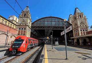
<span class="mw-page-title-main">Santa Teresa Tram</span> Tramway in Rio de Janeiro

The Santa Teresa Tram, or Tramway, is a historic tram line in Rio de Janeiro, Brazil. It connects the city's centre with the primarily residential, inner-city neighbourhood of Santa Teresa, in the hills immediately southwest of downtown. It is mainly maintained as a tourist attraction and is nowadays considered a heritage tramway system, having been designated a national historic monument in 1985. The line has a very unusual gauge: 1,100 mm. The main line is 6.0 kilometres long.

<span class="mw-page-title-main">Centro, Rio de Janeiro</span> Neighborhood in Rio de Janeiro, Rio de Janeiro, Brazil

Centro is a neighborhood in the Central Region of Rio de Janeiro, Brazil. It represents the financial heart of the city, and the crux of the Central Region.

<span class="mw-page-title-main">Zona Central, Rio de Janeiro</span> Neighborhood in Rio de Janeiro, Rio de Janeiro, Brazil

Zona Central is the historical, administrative, and financial centre of the city of Rio de Janeiro, Brazil. It has been undergoing a major revitalisation since it was rediscovered by locals in the 1990s.

<span class="mw-page-title-main">Aqueduct (bridge)</span> Structure constructed to convey water

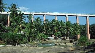
Aqueducts are bridges constructed to convey watercourses across gaps such as valleys or ravines. The term aqueduct may also be used to refer to the entire watercourse, as well as the bridge. Large navigable aqueducts are used as transport links for boats or ships. Aqueducts must span a crossing at the same level as the watercourses on each end. The word is derived from the Latin aqua ("water") and ducere, therefore meaning "to lead water". A modern version of an aqueduct is a pipeline bridge. They may take the form of tunnels, networks of surface channels and canals, covered clay pipes or monumental bridges.

<span class="mw-page-title-main">Rio de Janeiro Light Rail</span> Light rail system in Brazil

Rio de Janeiro Light Rail is a modern light rail system serving Rio de Janeiro, Brazil. The system is among several new public transport developments in the region ahead of the city's successful bid for the 2016 Summer Olympics. Its official name is VLT Carioca, the initialism "VLT" being equivalent to the English term light rail.

<span class="mw-page-title-main">Pedra Branca State Park</span> State park in Rio de Janeiro, Brazil

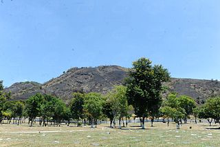
The Pedra Branca State Park is a state park in the state of Rio de Janeiro, Brazil. It is one of the largest urban nature parks in the world. It protects an area of Atlantic Forest in the west of the city of Rio de Janeiro that includes the highest point in the city, the Pico da Pedra Branca.

<span class="mw-page-title-main">Geography of Rio de Janeiro</span> Environment, climate and subdivisions of Rio de Janeiro

Rio de Janeiro is on the far western part of a strip of Brazil's Atlantic coast, close to the Tropic of Capricorn, where the shoreline is oriented east–west. Facing largely south, the city was founded on an inlet of this stretch of the coast, Guanabara Bay, and its entrance is marked by a point of land called Sugar Loaf – a "calling card" of the city.

<span class="mw-page-title-main">Outline of Rio de Janeiro</span> Overview of and topical guide to Rio de Janeiro

The following outline is provided as an overview of and topical guide to Rio de Janeiro:

<span class="mw-page-title-main">Colonial architecture of Brazil</span> Architecture carried out in the current Brazilian territory from 1500 until 1822.

The colonial architecture of Brazil is defined as the architecture carried out in the current Brazilian territory from 1500, the year of the Portuguese arrival, until its Independence, in 1822.

References

  1. "Arcos da Lapa". IBGE (in Portuguese).
  2. "Bonde accident Kills 5 in Rio". The Rio Times. August 28, 2011. Retrieved 2014-07-20.
  3. "Construction Continues As Santa Teresa Bonde Is Delayed". The Rio Times. May 6, 2014. Retrieved 2014-07-20.
  4. "Bondes de Santa Teresa recebem 2 mil passageiros no sábado" [Santa Teresa tram carries 2,000 passengers on Saturday]. G1 (Rede Globo). 1 August 2015. Retrieved 2015-11-29.