Related Research Articles
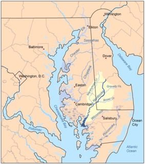
Marshyhope Creek is a 37.0-mile-long (59.5 km) tributary of the Nanticoke River on the Delmarva Peninsula. It rises in Kent County, Delaware, and runs through Caroline County, Maryland, and Dorchester County, Maryland.

Cedar Creek is a 16.09 mi (25.89 km) long 4th order tributary to Delaware Bay in Sussex and Kent Counties, Delaware.
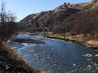
The Touchet River is a 55-mile (89 km) tributary of the Walla Walla River in southeastern Washington in the United States. The Touchet River drains an area of about 740 square miles (1,900 km2) in Columbia County and Walla Walla County.

Brower's Spring is a spring in the Centennial Mountains of Beaverhead County Montana that was marked by a surveyor in 1888 as the ultimate headwaters of the Missouri River and thus the fourth longest river in the world, the 3,902-mile-long (6,280 km) Mississippi-Missouri River.

Lingo Creek is a 1.7-mile-long (2.7 km) stream flowing southeast to Indian River Bay, 7.5 miles (12.1 km) northeast of Frankford in Sussex County, Delaware.
Myrtle Creek is a small stream, about 3 miles (5 km) long, in Curry County in the U.S. state of Oregon. It arises in the Siskiyou Mountains and flows generally southwest to its confluence with Mussel Creek in the Arizona Beach State Recreation Site. The two creeks flow under U.S. Highway 101 and through the park, where they merge and enter the Pacific Ocean about 10 miles (16 km) south of Port Orford.
Mussel Creek is a small stream, about 4 miles (6 km) long, in Curry County in the U.S. state of Oregon. It arises in the Siskiyou Mountains and flows generally west to its confluence with Myrtle Creek in the Arizona Beach State Recreation Site. The creeks flow under U.S. Highway 101 and through the park, where they merge and enter the Pacific Ocean about 10 miles (16 km) south of Port Orford.

Tartown, formerly an unincorporated community, is now an extinct community in Adams County, Pennsylvania, United States. The remains of Tartown are located on property of the Waynesboro, Pennsylvania, Borough Authority and in the adjacent Michaux State Forest in Hamiltonban Township. The locale has in part been inundated by the reservoir created by the Waynesboro Dam on the East Branch of the Antietam Creek. The name reportedly originates from the local production of pine tar. Wagamansville is a variant name.

Currant Creek is a stream in eastern Juab County and southern Utah County in northern Utah, United States.

Squirrel Creek is a 4.42 mi (7.11 km) long 2nd order tributary to Reedy Fork in Guilford County, North Carolina.
Beetree Creek is a 8.05 mi (12.96 km) long 2nd order tributary to the Swannanoa River in Buncombe County, North Carolina.
Little Brown Creek is a 3.43 mi (5.52 km) long 3rd order tributary to Brown Creek in Anson County, North Carolina. This creek is located on the left bank of Brown Creek and is different than the one on the right bank located downstream.

Twomile Creek is a 3.72 mi (5.99 km) long 2nd order tributary to East Branch Oil Creek in Crawford County, Pennsylvania.
Lake Creek is a 17.15 mi (27.60 km) long 3rd order tributary to Sugar Creek in Crawford and Venango County, Pennsylvania.
Mill Creek is a 11.36 mi (18.28 km) long 2nd order tributary to French Creek in Mercer and Venango County, Pennsylvania.
Cherry Walk Creek is a 1.45 mi (2.33 km) long first order tributary to Love Creek in Sussex County, Delaware.
Herring Creek is a 2.85 mi (4.59 km) long 3rd order tributary to Rehoboth Bay, in Sussex County, Delaware.
Lee Joseph Creek is a 0.42 mi (0.68 km) long 1st order tributary to Rehoboth Bay in Sussex County, Delaware. This stream is tidal for most of its course.

Long Creek is a 6.28 mi (10.11 km) long 2nd order tributary to Back Creek in Cecil County, Maryland.
Mill Creek is a 3.39 mi (5.46 km) long 2nd order tributary to Lanes Creek in Union County, North Carolina.
References
- ↑ Fay, Samuel Prescott (2010). The Forgotten Explorer: Samuel Prescott Fay's 1914 Expedition to the Northern Rockies. Rocky Mountain Books. pp. 1, 194, 275. ISBN 978-1-897522-55-4.
- ↑ "Big Sheep Creek Fishing near Rossland, British Columbia". HookandBullet. Retrieved 2 February 2013.
- ↑ "Nelson Star, 16 Apr 2017". www.nelsonstar.com.
- ↑ Basque, Garnet (2010). Lost Bonanzas of Western Canada, Volume 1. Heritage House Publishing. p. 153. ISBN 978-1-895811-40-7.
- ↑ "Sheep Creek USGS Ross Mountain Quad, Alabama, Topographic Map". TopoZone. Retrieved 2 February 2013.
- ↑ "Sheep Creek, Cleburne Co, Ala". AnyplaceAmerica. Retrieved 2 February 2013.
- ↑ "Alaska search results". GNIS. Retrieved 2 February 2013.
- ↑ Spencer, Arthur Coe; Wright, Charles L.; Wright, Charles Will (1906). The Juneau gold belt, Alaska: A reconnaissance of Admiralty Island, Alaska (Public domain ed.). Government Printing Office. pp. 48–. Retrieved 11 January 2013.
- ↑ "Thane, Alaska". GNIS. Retrieved 2 February 2013.
- ↑ "Sheep Creek Trail". Parks Canada. Retrieved 2 February 2013.
- ↑ "Sheep Dip Creek USGS Many Farms Quad, Arizona, Topographic Map". TopoZone. Retrieved 2 February 2013.
- ↑ "Sheep Creek USGS O W Point Quad, Arizona, Topographic Map". TopoZone. Retrieved 2 February 2013.
- ↑ "Sheep Creek Point USGS O W Point Quad, Arizona, Topographic Map". TopoZone. Retrieved 2 February 2013.
- ↑ "Sheep Creek USGS Horseshoe Dam Quad, Arizona, Topographic Map". TopoZone. Retrieved 2 February 2013.
- ↑ "Sheep Creek Seep USGS Lion Mountain Quad, Arizona, Topographic Map". TopoZone. Retrieved 2 February 2013.
- ↑ "South Fork Sheep Creek USGS Horseshoe Dam Quad, Arizona, Topographic Map". TopoZone. Retrieved 2 February 2013.
- ↑ "Upper Sheep Creek Spring USGS Lion Mountain Quad, Arizona, Topographic Map". TopoZone. Retrieved 2 February 2013.
- ↑ "Sheep Creek USGS Sunrise Peak Quad, Arizona, Topographic Map". TopoZone. Retrieved 2 February 2013.
- ↑ "Sheep Creek Cabin USGS Table Mountain Quad, Arizona, Topographic Map". TopoZone. Retrieved 2 February 2013.
- ↑ "Sheep Jump Creek USGS Big Flat Quad, Arkansas, Topographic Map". TopoZone. Retrieved 2 February 2013.
- ↑ "Calif Search Results". GNIS. Retrieved 2 February 2013.
- ↑ "Sheep Creek Campground USGS CEDAR GROVE Quad, California, Topographic Map". TopoZone. Retrieved 2 February 2013.
- ↑ "Sheep Creek USGS LOCKWOOD VALLEY Quad, California, Topographic Map". TopoZone. Retrieved 2 February 2013.
- ↑ "Colorado Search Results". GNIS. Retrieved 2 February 2013.
- ↑ "Sheep Creek USGS Osier Quad, Colorado, Topographic Map". TopoZone. Retrieved 2 February 2013.
- ↑ "Sheep Creek Trail USGS Crystal Mountain Quad, Colorado, Topographic Map". TopoZone. Retrieved 2 February 2013.
- ↑ "Sheep Creek USGS Devereux Quad, Georgia, Topographic Map". TopoZone. Retrieved 2 February 2013.
- ↑ "Idaho Search Results". GNIS. Retrieved 2 February 2013.
- ↑ "Sheep Creek USGS Hawkins Quad, Idaho, Topographic Map". TopoZone. Retrieved 2 February 2013.
- ↑ "Sheep Creek Dam USGS Pegram Quad, Idaho, Topographic Map". TpopZone. Retrieved 2 February 2013.
- ↑ "Sheep Creek USGS Bristol Quad, Indiana, Topographic Map". TopoZone. Retrieved 2 February 2013.
- ↑ "Sheep Creek USGS Williamsburg Quad, Kentucky, Topographic Map". TopoZone. Retrieved 2 February 2013.
- ↑ "Sheep Creek USGS Hamilton West Quad, Missouri, Topographic Map". TopoZone. Retrieved 2 February 2013.
- ↑ "East Sheep Creek USGS Hamilton West Quad, Missouri, Topographic Map". TopoZone. Retrieved 2 February 2013.
- ↑ "West Sheep Creek USGS Hamilton West Quad, Missouri, Topographic Map". TopoZone. Retrieved 2 February 2013.
- ↑ "Montana Search Results". GNIS. Retrieved 2 February 2013.
- 1 2 3 "Sheep Creek USGS Snider Hill Quad, MT, ND, SD, Topographic Map". TopoZone. Retrieved 2 February 2013.
- ↑ "Sheep Creek Trail USGS Felix Peak Quad, Montana, Topographic Map". TopoZone. Retrieved 2 February 2013.
- ↑ "Sheep Creek Bridge USGS Sheep Creek Quad, Montana, Topographic Map". TopoZone. Retrieved 2 February 2013.
- ↑ "Sheep Creek Reservoir USGS Stacey Quad, Montana, Topographic Map". TopoZone. Retrieved 2 February 2013.
- ↑ "Sheep Creek USGS Precept Quad, NE, KS, Topographic Map". TopoZone. Retrieved 2 February 2013.
- ↑ "Dry Sheep Creek USGS Morrill Quad, Nebraska, Topographic Map". TpopZone. Retrieved 2 February 2013.
- ↑ "Sheep Creek Election Precinct USGS Erdman Ranch Quad, Nebraska, Topographic Map". TopoZone. Retrieved 2 February 2013.
- ↑ "Nevada Search Results". GNIS. Retrieved 2 February 2013.
- ↑ "Sheep Creek Range USGS Sheep Creek Range SW Quad, Nevada, Topographic Map". TopoZone. Retrieved 2 February 2013.
- ↑ "Sheep Pen Creek USGS Ben Davis Point Quad, NJ, DE, Topographic Map". TopoZone. Retrieved 2 February 2013.
- ↑ "Sheep Spring Creek USGS McWilliams Canyon Quad, NM, CO, Topographic Map". TopoZone. Retrieved 2 February 2013.
- ↑ "Sheep Creek USGS Bonner Canyon Quad, New Mexico, Topographic Map". TopoZone. Retrieved 2 February 2013.
- ↑ "Sheep Creek USGS Honey Boy Ranch Quad, New Mexico, Topographic Map". TopoZone. Retrieved 2 February 2013.
- ↑ "Sheep Pen Creek USGS Styron Bay Quad, North Carolina, Topographic Map". TopoZone. Retrieved 2 February 2013.
- ↑ "Sheep Creek USGS Jarvisburg Quad, North Carolina, Topographic Map". TopoZone. Retrieved 2 February 2013.
- ↑ "Sheep Cliff Creek USGS Big Ridge Quad, North Carolina, Topographic Map". TopoZone. Retrieved 2 February 2013.
- ↑ "Sheep Creek USGS Harden City Quad, Oklahoma, Topographic Map". TopoZone. Retrieved 2 February 2013.
- ↑ "Oregon Search Results". GNIS. Retrieved 2 February 2013.
- ↑ Barstad, Fred (2002). Hiking Oregon's Eagle Cap Wilderness. FalconGuides. p. 277. ISBN 978-0-7627-2243-3.
- ↑ "Big Sheep Creek USGS Imnaha Quad, Oregon, Topographic Map". TopoZone. Retrieved 2 February 2013.
- ↑ "Sheep Creek Siphon USGS Cairo Quad, Oregon, Topographic Map". TopoZone. Retrieved 2 February 2013.
- ↑ "Sheep Creek USGS Zeona Quad, South Dakota, Topographic Map". TopoZone. Retrieved 2 February 2013.
- ↑ "Sheep Creek USGS Elephant Mountain Quad, Texas, Topographic Map". TopoZone. Retrieved 2 February 2013.
- ↑ "(Callahan Co) Sheep Creek USGS Putnam North Quad, Texas, Topographic Map". TopoZone. Retrieved 2 February 2013.
- ↑ "(Fannin Co) Sheep Creek USGS Mulberry Quad, TX, OK, Topographic Map". TopoZone. Retrieved 2 February 2013.
- ↑ "(Knox Co) Sheep Creek USGS Truscott South Quad, Texas, Topographic Map". TopoZone. Retrieved 2 February 2013.
- ↑ "Sheep Run Creek USGS Sheep Run Creek Quad, Texas, Topographic Map". TopoZone. Retrieved 2 February 2013.
- ↑ "Utah Search Results". GNIS. Retrieved 2 February 2013.
- ↑ "Sheep Creek USGS Manila Quad, UT, WY, Topographic Map". TopoZone. Retrieved 2 February 2013.
- ↑ "Sheep Creek Connecting Trail USGS Bryce Point Quad, Utah, Topographic Map". TopoZone. Retrieved 2 February 2013.
- ↑ "Sheep Creek USGS Peaks of Otter Quad, Virginia, Topographic Map". TpopZone. Retrieved 2 February 2013.
- ↑ "Sheep Creek USGS Cornwall Quad, Virginia, Topographic Map". TopoZone. Retrieved 2 February 2013.
- ↑ "Washington Search Results". GNIS. Retrieved 2 February 2013.
- ↑ "Sheep Creek Spring USGS Saddle Butte Quad, Washington, Topographic Map". TopoZone. Retrieved 2 February 2013.
- ↑ "Sheep Creek USGS Pyramid Mountain Quad, Washington, Topographic Map". TopoZone. Retrieved 2 February 2013.
- ↑ "Sheep Run USGS Cairo Quad, West Virginia, Topographic Map". TopoZpne. Retrieved 2 February 2013.
- ↑ "Sheep Ranch Creek USGS Rib Lake Quad, Wisconsin, Topographic Map". TopoZone. Retrieved 2 February 2013.
- ↑ "Wyoming Search Results". GNIS. Retrieved 2 February 2013.
- ↑ "Sheep Creek Mine USGS Rogers Creek Quad, Wyoming, Topographic Map". TopoZone. Retrieved 2 February 2013.
- ↑ "East Fork Sheep Creek USGS Shotgun Butte Quad, Wyoming, Topographic Map". TopoZone. Retrieved 2 February 2013.
- ↑ "Sheep Creek Oil Field USGS Jeffrey City Quad, Wyoming, Topographic Map". TopoZone. Retrieved 2 February 2013.
- ↑ "Sheep Dip Creek USGS South Fork Mountain Quad, Wyoming, Topographic Map". TopoZone. Retrieved 2 February 2013.