List of urbanized areas in Florida (by population)

Last updated

Map of Florida Urbanized Areas according the 2010 census Florida Urbanized Areas.jpg
Map of Florida Urbanized Areas according the 2010 census
Miami-Fort Lauderdale Miami skyline 20080516.png
Miami-Fort Lauderdale
Tampa-St. Petersburg Downtowntampa08.jpg
Tampa-St. Petersburg
Orlando Lake Eola Park in Orlando 02.jpg
Orlando
Jacksonville JacksonvilleSkyline.jpg
Jacksonville
Bradenton-Sarasota-Venice Sarasota Bay and waterfront, Sarasota, Florida (2003).jpg
Bradenton-Sarasota-Venice
Cape Coral ISS047-E-84351 Cape Coral, Florida.jpg
Cape Coral
Palm Bay-Melbourne Airboat returns at sunset (22344608645).jpg
Palm Bay-Melbourne
Port St. Lucie PGA Village.jpg
Port St. Lucie
Bonita Springs-Estero Bonita Springs, FL, USA - panoramio (4).jpg
Bonita Springs-Estero
Kissimmee-St.Cloud Kissimmee-Advertisment.jpg
Kissimmee-St.Cloud

The United States Census Bureau defines an Urbanized Area to be "one or more places ('central place') and the adjacent densely settled surrounding territory ('urban fringe') that together have a minimum of 50,000 persons." There are a number of rules specifying what is included in the urban fringe, but it "generally consists of contiguous territory having a density of at least 1,000 persons per square mile". [1] Urbanized Areas often form the cores of Metropolitan Statistical Areas, and as they comprise census tracts rather than local political subdivisions (counties, in Florida), they are generally smaller than the corresponding Metropolitan Statistical Area. A Metropolitan Statistical Area may have more than one Urbanized Area within its boundaries, and an Urbanized Area may extend into more than one Metropolitan Statistical Area. [2] As of 2020, the US Census Bureau has defined thirty-three Urbanized Areas in Florida. [3]

List

The United States Census Bureau defines an Urbanized Area to be "one or more places ('central place') and the adjacent densely settled surrounding territory ('urban fringe') that together have a minimum of 50,000 persons." There are a number of rules specifying what is included in the urban fringe, but it "generally consists of contiguous territory having a density of at least 1,000 persons per square mile". [1] Urbanized Areas often form the cores of Metropolitan Statistical Areas, and, as they comprise census tracts rather than local political subdivisions (counties, in Florida), they are generally smaller than the corresponding Metropolitan Statistical Area. A Metropolitan Statistical Area may have more than one Urbanized Area within its boundaries, and an Urbanized Area may extend into more than one Metropolitan Statistical Area. [2] As of 2020, the US Census Bureau has defined thirty-three Urbanized Areas in Florida. [3]

RankNamePopulation
in 2020 [3]
Metro AreasRecent former name(s)
1 Miami-Fort Lauderdale 6,077,522 Miami-Ft. Lauderdale- Pompano Beach Metropolitan Statistical Area Miami
2 Tampa-St. Petersburg 2,783,045 Tampa-St. Petersburg-Clearwater, Florida Metropolitan Statistical Area
3 Orlando 1,853,896 Orlando-Kissimmee, Florida, Metropolitan Statistical Area
4 Jacksonville 1,247,374 Jacksonville Metropolitan Statistical Area
5 Bradenton - Sarasota - Venice 779,075 North Port–Sarasota–Bradenton metropolitan statistical area and Punta Gorda, Florida Metropolitan Statistical Area Sarasota - Bradenton
6 Cape Coral 599,242 Cape Coral-Fort Myers, Florida Metropolitan Statistical Area
7 Palm Bay-Melbourne 510,675 Palm Bay-Melbourne-Titusville, Florida Metropolitan Statistical Area
8 Port St. Lucie 437,745 Port St. Lucie, Florida Metropolitan Statistical Area
9 Bonita Springs - Estero 425,675 Naples-Marco Island, Florida Metropolitan Statistical Area and Cape Coral-Fort Myers, Florida Metropolitan Statistical Area Bonita Springs
10 Kissimmee - St. Cloud 418,404 Orlando-Kissimmee, Florida, Metropolitan Statistical Area Kissimmee
11 Daytona Beach - Palm Coast - Port Orange 402,126 Deltona-Daytona Beach-Ormond Beach, Florida Metropolitan Statistical Area Palm Coast - Daytona Beach - Port Orange and Daytona Beach - Port Orange
12 Pensacola 390,172 Pensacola-Ferry Pass-Brent Metropolitan Statistical Area
13 Lakeland 277,915 Lakeland, Florida Metropolitan Statistical Area
14 Winter Haven 253,251 Lakeland, Florida Metropolitan Statistical Area
15 Tallahassee 252,934 Tallahassee, Florida Metropolitan Statistical Area
16 Navarre - Miramar Beach - Destin 226,213 Fort Walton Beach-Crestview-Destin, Florida Metropolitan Statistical Area and Pensacola-Ferry Pass-Brent, Florida Metropolitan Statistical Area Fort Walton Beach - Navarre - Wright and

Fort Walton Beach

17 Gainesville 213,748 Gainesville, Florida Metropolitan Statistical Area
18 Deltona 210,712 Deltona-Daytona Beach-Ormond Beach, Florida Metropolitan Statistical Area
19 Port Charlotte - North Port 199,998 Punta Gorda, Florida Metropolitan Statistical Area and Sarasota-Bradenton-Venice, Florida Metropolitan Statistical Area North Port - Port Charlotte
20 Ocala 182,647 Ocala, Florida Metropolitan Statistical Area
21 Vero Beach - Sebastian 174,292 Sebastian-Vero Beach, Florida Metropolitan Statistical Area, Palm Bay-Melbourne-Titusville, Florida Metropolitan Statistical Area and Port St. Lucie, Florida Metropolitan Statistical Area Sebastian - Vero Beach South - Florida Ridge
22 Spring Hill 169,050 Tampa-St. Petersburg-Clearwater, Florida Metropolitan Statistical Area Brooksville
23 Panama City - Panama City Beach 162,060 Panama City-Lynn Haven, Florida Metropolitan Statistical Area Panama City
24 The Villages - Lady Lake 161,736 Orlando-Kissimmee, Florida, Metropolitan Statistical Area, Ocala, Florida Metropolitan Statistical Area and Sumter County Lady Lake - The Villages and Lady Lake
25 Leesburg-Eustis-Tavares 151,523 Orlando-Kissimmee, Florida, Metropolitan Statistical Area Leesburg - Eustis
26 Beverly Hills - Homosassa Springs - Pine Ridge 96,729 Homosassa Springs, Florida Metropolitan Statistical Area Homosassa Springs - Beverly Hills - Citrus Springs
27 Four Corners 92,396 Orlando-Kissimmee, Florida, Metropolitan Statistical Area and Lakeland, Florida metropolitan area
28 St. Augustine 91,786 Jacksonville Metropolitan Statistical Area
29 Sebring-Avon Park 63,297 Sebring, Florida Metropolitan Statistical Area
30 Titusville 62,459 Palm Bay-Melbourne-Titusville, Florida Metropolitan Statistical Area
31 Zephyrhills 55,133 Tampa-St. Petersburg-Clearwater, Florida Metropolitan Statistical Area
32 Poinciana 53,267 Orlando-Kissimmee, Florida, Metropolitan Statistical Area and Lakeland, Florida metropolitan area
33 Fernandina Beach - Yulee 50,805 Jacksonville Metropolitan Statistical Area

Related Research Articles

<span class="mw-page-title-main">Metropolitan area</span> Administrative unit of a dense urban core and its satellite cities

A metropolitan area or metro is a region consisting of a densely populated urban agglomeration and its surrounding territories sharing industries, commercial areas, transport network, infrastructures and housing. A metropolitan area usually comprises multiple principal cities, jurisdictions and municipalities: neighborhoods, townships, boroughs, cities, towns, exurbs, suburbs, counties, districts and even states and nations in areas like the eurodistricts. As social, economic and political institutions have changed, metropolitan areas have become key economic and political regions.

In the United States, a metropolitan statistical area (MSA) is a geographical region with a relatively high population density at its core and close economic ties throughout the region. Such regions are not legally incorporated as a city or town would be and are not legal administrative divisions like counties or separate entities such as states. As a result, sometimes the precise definition of a given metropolitan area will vary between sources. The statistical criteria for a standard metropolitan area were defined in 1949 and redefined as a metropolitan statistical area in 1983.

<span class="mw-page-title-main">Exurb</span> Area of lower population density than suburbs

An exurb is an area outside the typically denser inner suburban area, at the edge of a metropolitan area, which has some economic and commuting connection to the metro area, low housing density, and growth. It shapes an interface between urban and rural landscapes holding a limited urban nature for its functional, economic, and social interaction with the urban center, due to its dominant residential character. Exurbs consist of "agglomerations of housing and jobs outside the municipal boundaries of a primary city" and beyond the surrounding suburbs.

A census-designated place (CDP) is a concentration of population defined by the United States Census Bureau for statistical purposes only.

<span class="mw-page-title-main">Core-based statistical area</span> Statistical area of the United States

A core-based statistical area (CBSA) is a U.S. geographic area defined by the Office of Management and Budget (OMB). It contains a large population nucleus, or urban area, and adjacent communities that have a high degree of integration with that nucleus.

A township in some states of the United States is a small geographic area.

<span class="mw-page-title-main">Census geographic units of Canada</span> Term used in Canada

The census geographic units of Canada are the census subdivisions defined and used by Canada's federal government statistics bureau Statistics Canada to conduct the country's quinquennial census. These areas exist solely for the purposes of statistical analysis and presentation; they have no government of their own. They exist on four levels: the top-level (first-level) divisions are Canada's provinces and territories; these are divided into second-level census divisions, which in turn are divided into third-level census subdivisions and fourth-level dissemination areas.

<span class="mw-page-title-main">Urban area</span> Human settlement with high population density and infrastructure of built environment

An urban area, built-up area or urban agglomeration is a human settlement with a high population density and an infrastructure of built environment. This is the core of a metropolitan statistical area in the United States, if it contains a population of more than 50,000.

<span class="mw-page-title-main">Miami metropolitan area</span> Metropolis in the U.S. state of Florida

The Miami metropolitan area, also known as South Florida, SoFlo, SoFla, the Gold Coast, the Tri-County Area, or Greater Miami, and officially the Miami–Fort Lauderdale–West Palm Beach Metropolitan Statistical Area, is a coastal metropolitan area in southeastern Florida. It is the ninth-largest metropolitan statistical area (MSA) in the United States, the second-largest metropolitan area in the Southern United States, and the largest metropolitan area in Florida. With a population of 6.14 million, its population exceeds 31 of the nation's 50 states as of 2022. It comprises the three most populated counties in the state, Miami-Dade County, Broward County, and Palm Beach County, which rank as the first, second, and third-most populous counties in the state, respectively. Miami-Dade County, with 2,716,940 people in 2019, is the seventh-most populous county in the United States.

An urban area or tätort in Sweden has a minimum of 200 inhabitants and may be a city, town or larger village. It is a purely statistical concept, not defined by any municipal or county boundaries. Larger urban areas synonymous with cities or towns for statistical purposes have a minimum of 10,000 inhabitants. The same statistical definition is also used for urban areas in the other Nordic countries.

<span class="mw-page-title-main">Human settlement</span> Community of any size, in which people live

In geography, statistics and archaeology, a settlement, locality or populated place is a community of people living in a particular place. The complexity of a settlement can range from a minuscule number of dwellings grouped together to the largest of cities with surrounding urbanized areas. Settlements may include hamlets, villages, towns and cities. A settlement may have known historical properties such as the date or era in which it was first settled, or first settled by particular people. The process of settlement involves human migration.

<span class="mw-page-title-main">Florida statistical areas</span> Florida statistical areas

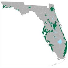
The U.S. State of Florida currently has 35 statistical areas that have been delineated by the Office of Management and Budget (OMB). On July 21, 2023, the OMB delineated 7 combined statistical areas, 22 metropolitan statistical areas, and 6 micropolitan statistical areas in Florida.

<span class="mw-page-title-main">Iowa statistical areas</span> Iowa statistical areas

The U.S. State of Iowa currently has 30 statistical areas that have been delineated by the Office of Management and Budget (OMB). On March 6, 2020, the OMB delineated six combined statistical areas, nine metropolitan statistical areas, and 15 micropolitan statistical areas in Iowa.

<span class="mw-page-title-main">Peri-urbanisation</span> Type of urban growth

Peri-urbanisation relates to the processes of scattered and dispersive urban growth that create hybrid landscapes of fragmented and mixed urban and rural characteristics. Such areas may be referred to as the rural–urban fringe, the outskirts, or the urban hinterland.

References

  1. 1 2 US Census Bureau Urban and Rural definitions - URL retrieved August 22, 2006
  2. 1 2 State-sorted corrected list of Urbanized Areas as of 2002 - URL retrieved August 22, 2006
  3. 1 2 3 "List of 2020 Census Urban Areas". United States Census Bureau . Retrieved December 30, 2022.