Related Research Articles
The London Borough of Hackney is a London borough in Inner London. The historical and administrative heart of Hackney is Mare Street, which lies 5 miles (8 km) north-east of Charing Cross. The borough is named after Hackney, its principal district. Southern and eastern parts of the borough are popularly regarded as being part of east London, with the northwest belonging to north London.

The London Borough of Harrow is a London borough in north-west London, England, and forms part of Outer London. It borders four other London boroughs – Barnet to the east of ancient Watling Street, Brent to the south-east, Ealing to the south and Hillingdon to the west – plus the Hertfordshire districts of Three Rivers and Hertsmere to the north. The local authority is Harrow London Borough Council. The London borough was formed in 1965, based on boundaries that had been established in 1934. The borough is made up of three towns: Harrow proper, Pinner, and Stanmore, but also includes western parts of Edgware; it is of suburban character and includes some countryside in the northern outskirts.

The London Borough of Richmond upon Thames in southwest London forms part of Outer London and is the only London borough on both sides of the River Thames. It was created in 1965 when three smaller council areas amalgamated under the London Government Act 1963. It is governed by Richmond upon Thames London Borough Council and is divided into nineteen wards. The population is 198,019 and the major settlements are Barnes, East Sheen, Mortlake, Richmond, Twickenham, Teddington and Hampton.

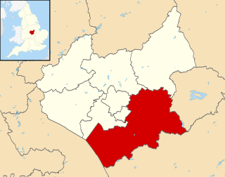
The Borough of Rugby is a local government district with borough status in eastern Warwickshire, England. The borough comprises the town of Rugby where the council has its headquarters, and the rural areas surrounding the town. The borough has a population of 108,935. Of which, 77,285 live in Rugby itself and the remainder living in the surrounding areas. More notable settlements include Binley Woods, Clifton-upon-Dunsmore, Dunchurch, Ryton-on-Dunsmore, Stretton-on-Dunsmore and Wolston.
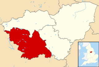
Harborough is a local government district of Leicestershire, England, named after its main town, Market Harborough. Covering 230 square miles (600 km2), the district is by far the largest of the eight district authorities in Leicestershire and covers almost a quarter of the county.

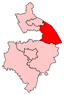
Broxtowe is a local government district with borough status in Nottinghamshire, England, west of the City of Nottingham. The population of the district as taken at the 2011 Census was 109,487. It is part of the Nottingham Urban Area. Broxtowe's neighbour to the west is the borough of Erewash, which is in Derbyshire.

Warwick is a local government district of central Warwickshire in England. It borders the Borough of Rugby and Stratford-on-Avon District in Warwickshire as well as the West Midlands County. The City of Coventry is to the north and northeast, the Stratford-on-Avon District to the southwest and south, the Borough of Rugby to the east, and the Borough of Solihull to the west and northwest.

Rushcliffe is a local government district with borough status in Nottinghamshire, England. The population of the Local Authority at the 2011 Census was 111,129. Its council, Rushcliffe Borough Council(0115 981 9911), is based in West Bridgford. It was formed on 1 April 1974 by merging the West Bridgford Urban District, the Bingham Rural District and part of Basford Rural District.

Babergh District is a local government district in Suffolk, England. Primarily a rural area, Babergh contains two towns of notable size: Sudbury, and Hadleigh, which was the administrative centre until 2017. Its council headquarters, which are shared with neighbouring Mid Suffolk, are now based in Ipswich.

The Borough of Fareham is a local government district and borough in Hampshire, England. Its council is based in Fareham. Other places within the borough include Portchester, Hill Head, Stubbington, Titchfield, Warsash, Locks Heath, Sarisbury and half of Whiteley. The borough covers much of the semi-urban area between the cities of Southampton and Portsmouth, and is part of the South Hampshire conurbation, with many residents commuting to the two cities for employment.

The City of Salford is a metropolitan borough with the status of a city in Greater Manchester, England. The borough is named after its main settlement, Salford. The borough covers the towns of Eccles, Swinton, Walkden and Pendlebury. As well as the villages and suburbs of Monton, Little Hulton, Boothstown, Ellenbrook, Clifton, Cadishead, Pendleton, Winton and Worsley. The city has a population of 245,600, and is administered from the Salford Civic Centre in Swinton. Salford is the historic centre of the Salford Hundred which was never formally ceased as a division of Lancashire.
The City of Sheffield is a city and metropolitan borough in South Yorkshire, England. The metropolitan borough includes the administrative centre of Sheffield, the town of Stocksbridge and larger village of Chapeltown and part of the Peak District. It has a population of 584,853, making it technically the third largest city in England by population behind Birmingham and Leeds, since London is not considered a single entity. It is governed by Sheffield City Council.

The City of Wakefield is a local government district with the status of a city and metropolitan borough in West Yorkshire, England. Wakefield, the largest settlement, is the administrative centre of the district. The population of the City of Wakefield at the 2011 Census was 325,837. The district includes the Five Towns, Normanton, Pontefract, Featherstone, Castleford and Knottingley. Other towns include Ossett, Horbury, Hemsworth, South Kirkby and Moorthorpe and South Elmsall. The city and district are governed by Wakefield Metropolitan District Council from headquarters in County Hall.

The Borough of Burnley is a local government district with the borough status in Lancashire, England. It has an area of 42.7 square miles (110.7 km2) and a population of 88,920 (mid-2019 est.), and is named after its largest town, Burnley. Other notable settlements include Padiham, Hapton, Worsthorne, Briercliffe and Cliviger.

Aberavon is a town and community in Neath Port Talbot county borough, Wales. The town derived its name from being near the mouth of the river Afan, which also gave its name to a medieval lordship. Today it is essentially a district of Port Talbot, covering the central and south western part of the town. Aberavon is also the name of the nearby Blue Flag beach and the parish covering the same area.

Whiston is a town and civil parish within the Metropolitan Borough of Knowsley in Merseyside, England. Previously recorded within the historic county of Lancashire, it is located eight miles east of Liverpool. The population was 13,629 at the 2001 Census, increasing to 14,263 at the 2011 Census.
One third of Rugby Borough Council is elected each year, followed by one year without election.
Rugby is a constituency represented in the House of Commons of the UK Parliament since its 2010 recreation by Mark Pawsey, a Conservative.
Luddendenfoot or Luddenden Foot is a community in Calderdale, West Yorkshire, England. The population of Luddendenfoot is 2,547, with the wider Calderdale Ward at the 2011 Census as 10,653. It lies along the Upper Calder Valley below the village of Luddenden, between Sowerby Bridge and Mytholmroyd
Marshfield is an electoral ward and smaller village and community of Newport, Wales. The village sits approximately 5 miles southwest of Newport, and 7 miles northeast of Cardiff. The area is governed by Newport City Council.
References
- ↑ "RUGBY District in West Midlands Subdivision". City Population. Retrieved 20 October 2018.