Clifton-upon-Dunsmore

Last updated • 4 min readFrom Wikipedia, The Free Encyclopedia

Clifton-upon-Dunsmore
Cottages and monument, Clifton-upon-Dunsmore. 5.20.jpg
Looking towards Church Street from Lilbourne Road.
Warwickshire UK location map.svg
Red pog.svg
Clifton-upon-Dunsmore
Location within Warwickshire
Population2,991 (2021)
OS grid reference SP529764
Civil parish
  • Clifton upon Dunsmore
District
Shire county
Region
Country England
Sovereign state United Kingdom
Post town RUGBY
Postcode district CV23
Dialling code 01788
Police Warwickshire
Fire Warwickshire
Ambulance West Midlands
UK Parliament
List of places
UK
England
Warwickshire
52°22′59″N1°13′16″W / 52.383°N 1.221°W / 52.383; -1.221

Clifton-upon-Dunsmore is a village and civil parish in the Rugby borough of Warwickshire in England on the north-eastern outskirts of Rugby, approximately 2 miles (3.2 km) from Rugby town centre. The population of the parish taken at the 2011 census was 1,304, increasing to 2,991 at the 2021 census. [1] Clifton is counted as being part of the Rugby built-up area, [2] but is considered separate from the town. The parish also includes the new development of Houlton to the south of the old village, which may account for the large population increase since 2011.

Contents

Location

Clifton bears the distinction of being the most easterly village in Warwickshire (and of the entire West Midlands region). The village is located on a fairly steep hill, which at its highest point elevates to 400 feet (120 m) above sea level. The Oxford Canal runs past at the foot of the hill to the south-west. To the north of the village is the River Avon. [3] [4] Around 1.2 miles (1.9 km) north-east of Clifton is Dow Bridge, where the A5 road (Watling Street) crosses the River Avon, and the counties of Warwickshire, Northamptonshire and Leicestershire meet, forming a tripoint. [4]

History

St Mary's Church Clifton-upon-Dunsmore church.jpg
St Mary's Church

The area around Clifton was settled during Roman times; around one and a half miles north of Clifton is the former Roman town of Tripontium. [4] The area around Clifton has been suggested as a possible location of the Defeat of Boudica. [5] The name of the village likely derives from 'Cliffe' in Old English signifying rocky ground, and 'Dunsmore' on top of a hill. [4]

During the time of Edward the Confessor Clifton was in the hands of Alwyn, the Sheriff of Warwick who gave his land at Clifton to Coventry Priory; monks from which were likely responsible for building a church here dedicated to St. Mary, which at the time of the Domesday Book was the mother church to the then smaller settlement of Rugby. That church no longer exists, though the present one (of the same name) dates back to the 13th century, with later additions, including the current tower which was added in the 16th century replacing a spire which had collapsed in a storm. [3] [4] The church is now grade II* listed. [6]

The ancient parish of Clifton included the nearby settlements of Brownsover and Newton; the former is now part of Rugby, and the latter is now a separate civil parish. To the south-east of the village and within the parish was the former Rugby Radio Station, [7] which operated between 1926 and 2007, and is now a large housing development called Houlton.

The village was once served by Clifton Mill railway station on the former Rugby and Stamford Railway. The station opened in 1864, and was closed in 1953, and the line in 1966. [8]

At the village was once Rugby Racecourse, which was used for horse racing from 1862 until 1936. The National Hunt Chase Challenge Cup, now part of the Cheltenham Festival, was held here in 1862. [9] [10]

Commerce

The Bull Inn Bull Inn, Main Street, Clifton-upon-Dunsmore.5.20.jpg
The Bull Inn

In the centre of the village are small shops, St Mary's Church (whose registers for which date back to 1594), and the Bull Inn public house, which was originally a farmhouse, and according to a plaque on the entrance it was built in 1598 and became a public house in 1825. There were rooms for travellers and stables for their horses, some evidence of which still survives. There was formerly a second public house, the Red Lion, which was converted to cottages and the Townsend Memorial Hall in the late 19th century.

Part of the North Oxford Canal also travels within the boundaries of the village, the canal opened in 1790 but during the 1800s they cut 14 miles off its length straightening it to what is now the most navigated part of the canal system in the United Kingdom. Part of the old route subsequently fell into decay, until it was reopened in 2016/2017 by Clifton Wharf where there is a hire fleet based. Clifton Cruisers has been operating from the site at Clifton Wharf since the early 1970s and now has a cafe & bar, The Canal Lounge at Bridge 66. In Houlton The Barn is a community centre/village hall which holds communal classes and clubs and can be hired for parties or events. [11] The Tuning Fork is a restaurant which is open to the public. [12]

Education

The village has a primary school, Clifton-upon-Dunsmore Primary School which has been in continuous use since 1850. [3] Houlton has a primary school named St Gabriel's. Secondary-age pupils attend schools in Rugby or Houlton School which opened in 2021.

Notable people

Related Research Articles

<span class="mw-page-title-main">Stratford-upon-Avon</span> Town in Warwickshire, England

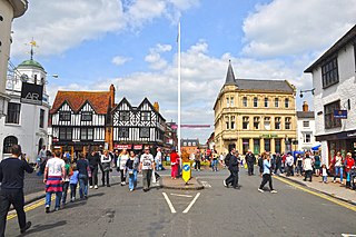
Stratford-upon-Avon, commonly known as just Stratford, is a market town and civil parish in the Stratford-on-Avon district, in the county of Warwickshire, in the West Midlands region of England. It is situated on the River Avon, 91 miles (146 km) north-west of London, 22 miles (35 km) south-east of Birmingham and 8 miles (13 km) south-west of Warwick. The town is the southernmost point of the Arden area at the northern extremity of the Cotswolds. In the 2021 census Stratford had a population of 30,495.

<span class="mw-page-title-main">Rugby, Warwickshire</span> Town in Warwickshire, England

Rugby is a market town in eastern Warwickshire, England, close to the River Avon. At the 2021 census, its population was 78,117, making it the second-largest town in Warwickshire. It is the main settlement within the larger Borough of Rugby, which had a population of 114,400 in 2021.

<span class="mw-page-title-main">Southam</span> Market town in Warwickshire, England

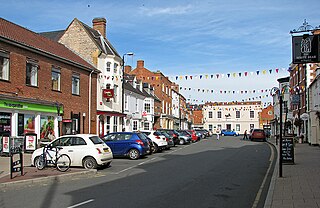
Southam is a market town and civil parish in the Stratford-on-Avon district of Warwickshire, England, located about 6+12 miles (10 km) east-southeast of Leamington Spa. In the 2021 census, the population of Southam was 8,114.

<span class="mw-page-title-main">Warwick</span> Town and the county town of Warwickshire, England

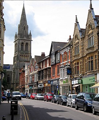
Warwick is a market town, civil parish and the county town of Warwickshire in the Warwick District in England, adjacent to the River Avon. It is 9 miles (14 km) south of Coventry, and 19 miles (31 km) south-east of Birmingham. It is adjoined with Leamington Spa and Whitnash.

<span class="mw-page-title-main">Borough of Rugby</span> Borough and non-metropolitan district in England

The Borough of Rugby is a local government district with borough status in Warwickshire, England. The borough comprises the town of Rugby where the council has its headquarters, and the rural areas surrounding the town. At the 2021 census the borough had a population of 114,400, of which 78,125 lived in the built-up area of Rugby itself and the remainder were in the surrounding areas.

<span class="mw-page-title-main">Shipston-on-Stour</span> Human settlement in England

Shipston-on-Stour is a town and civil parish in the Stratford-on-Avon District in southern Warwickshire, England. It is located on the banks of the River Stour, 9 miles (15 km) south-southeast of Stratford-upon-Avon, 10 miles north-northwest of Chipping Norton, 14 miles (22 km) south of Warwick and 14.5 miles west of Banbury. In the 2021 census, Shipston-on-Stour had a population of 5,849.

<span class="mw-page-title-main">Warwickshire</span> County of England

Warwickshire is a ceremonial county in the West Midlands of England. It is bordered by Staffordshire and Leicestershire to the north, Northamptonshire to the east, Oxfordshire and Gloucestershire to the south, and Worcestershire and the West Midlands county to the west. The largest settlement is Nuneaton and the county town is Warwick.

<span class="mw-page-title-main">Knowle, West Midlands</span> Human settlement in England

Knowle is a large village situated 3 miles (5 km) east-southeast of the town of Solihull, in the county of the West Midlands, England. Knowle lies within the Arden area of the historic county boundaries of Warwickshire, and since 1974 it has been part of the Metropolitan Borough of Solihull. It lies 2.5 miles from the Warwickshire border and had a recorded population of 10,678.

<span class="mw-page-title-main">Shirley, West Midlands</span> Town in England

Shirley is a town in the Metropolitan Borough of Solihull, in the West Midlands, England. Historically a rural settlement within the county of Warwickshire, it is now contiguous with nearby Solihull and Birmingham.

<span class="mw-page-title-main">Barby, Northamptonshire</span> Village in Northamptonshire, England

Barby is a village and civil parish about 5 miles (8 km) north of Daventry in Northamptonshire, England. The 2011 Census recorded the parish population as 2,336. Barby is located right off the M45 motorway a short spur from the M1 motorway to the A45 Trunk Road.

<span class="mw-page-title-main">Newbold-on-Avon</span> Human settlement in England

Newbold-on-Avon is a suburb of Rugby in Warwickshire, England, located around 1½ miles north-west of the town centre, it is adjacent to the River Avon from which the suffix is derived. Newbold was historically a village in its own right, but was incorporated into Rugby in 1932. The name is derived from the Saxon Niowebold.

<span class="mw-page-title-main">Wolston</span> Human settlement in England

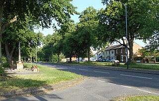
Wolston is a village and civil parish in the Rugby borough of Warwickshire, England. The village is located approximately midway between Rugby and Coventry, with a population of 2,692 at the 2021 census. It is close to the A45 road and the Roman road the Fosse Way.

<span class="mw-page-title-main">Hillmorton</span> Human settlement in England

Hillmorton is a suburb of Rugby, Warwickshire, England, around 2 miles (3.2 km) south-east of Rugby town centre, forming much of the eastern half of the town. It is also a ward of the Borough of Rugby. Hillmorton was historically a village in its own right, but was incorporated into Rugby in 1932. Hillmorton also encompasses the Paddox housing estate to the west of the old village, which is shown on many maps as 'Hillmorton Paddox', this area however is part of a separate ward called 'Paddox'.

Brownsover is a residential and commercial area of Rugby, Warwickshire in England, about 1+12 miles north of the town centre. The area is named after the original hamlet of Brownsover. Since 1960, the area has been subsumed by the expansion of Rugby, with the construction of a number of housing estates, industrial estates and retail parks.

<span class="mw-page-title-main">Wilmcote</span> Village in Warwickshire, England

Wilmcote is a village, and since 2004 a separate civil parish, in the English county of Warwickshire, about 3 miles (5 km) north of Stratford-upon-Avon. Prior to 2004, it was part of the same parish as Aston Cantlow, and the 2001 population for the whole area was 1,670, reducing to 1,229 at the 2011 Census.

<span class="mw-page-title-main">Hockley Heath</span> Human settlement in England

Hockley Heath is a village and civil parish within the Metropolitan Borough of Solihull, West Midlands, England. The village is to the south of the West Midlands conurbation, 12 miles (19 km) southeast of Birmingham 5.5 miles (8.9 km) from Solihull town centre and 13 miles (21 km) north of Stratford-upon-Avon. Hockley Heath is in the Arden area and borders Warwickshire and the District of Stratford-on-Avon to the south, with some parts of the village on either side of the border. It incorporates the hamlet of Nuthurst, and has a history dating back to the year 705 AD as a wood owned by Worcester Cathedral. The 2011 Census gives the population of Hockley Heath civil parish as 2,038.

<span class="mw-page-title-main">Harborough Magna</span> Human settlement in England

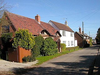
Harborough Magna is a village and civil parish in the Rugby district, in the county of Warwickshire, England. The civil parish which also contains the nearby hamlets of Harborough Parva and Cathiron, had a population of 502 at the 2011 Census, decreasing to 481 at the 2021 Census.

<span class="mw-page-title-main">Blisworth</span> Human settlement in England

Blisworth is a village and civil parish in West Northamptonshire, England. The West Coast Main Line, from London Euston to Manchester and Scotland, runs alongside the village partly hidden and partly on an embankment. The Grand Union Canal passes through the village and the north portal of the Blisworth Tunnel is near Stoke Road.

<span class="mw-page-title-main">Church Lawford</span> Village in Warwickshire, England

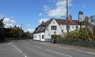
Church Lawford is a village and civil parish in Warwickshire, England. It is located just under 2.5 miles (4 km) west of the town of Rugby and 4.5 miles (7 km) east of Coventry. The population of the civil parish taken at the 2021 census was 432.

<span class="mw-page-title-main">St Michael and All Angels Church, Brownsover</span> Church in Warwickshire, England

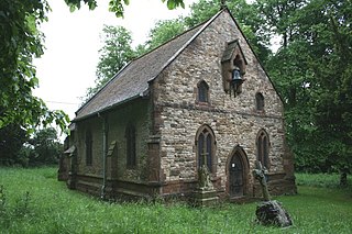
St Michael and All Angels Church is a redundant Anglican church in the former village of Brownsover, which is now a suburb of the town of Rugby, Warwickshire, England. It is recorded in the National Heritage List for England as a designated Grade II* listed building, and is under the care of the Churches Conservation Trust.

References

  1. "CLIFTON UPON DUNSMORE Parish in West Midlands". City Population. Retrieved 1 January 2019.
  2. "RUGBY in Warwickshire (West Midlands) Built-up Area Subdivision". City Population. Retrieved 5 August 2020.
  3. 1 2 3 Geoff, Allen (2000). Warwickshire Towns & Villages. Sigma Press. p. 42. ISBN   1-85058-642-X.
  4. 1 2 3 4 5 The Warwickshire Village Book. Countryside Books. 2000. pp. 46–48. ISBN   1-85306-652-4.
  5. "Boudica and Clifton... the final battle of the Celtic Revolt of AD60". Clifton-upon-Dunsmore Local History Group. Archived from the original on 4 February 2007. Retrieved 2 October 2019.
  6. Historic England. "CHURCH OF ST MARY THE VIRGIN (1233440)". National Heritage List for England . Retrieved 2 October 2019.
  7. "Parishes: Clifton-on-Dunsmore". British History Online. Retrieved 2 October 2019.
  8. "Clifton Mill station" . Retrieved 23 April 2016.
  9. "RUGBY'S LOST RACECOURSE". Our Warwickshire. Retrieved 2 October 2019.
  10. Stevens, Peter, History of the National Hunt Chase 1860-2010, pp. 15–16. ISBN   978-0-9567250-0-4
  11. Mention of The Barn in a Rugby Advertiser article
  12. The Tuning Fork website