
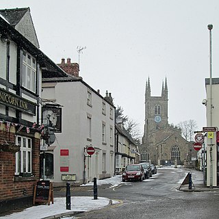
Rugby is a market town in eastern Warwickshire, England, close to the River Avon. At the 2021 census, its population was 78,117, making it the second-largest town in Warwickshire. It is the main settlement within the larger Borough of Rugby, which had a population of 114,400 in 2021.

Watling Street is a historic route in England that crosses the River Thames at London and which was used in Classical Antiquity, Late Antiquity, and throughout the Middle Ages. It was used by the ancient Britons and paved as one of the main Roman roads in Britannia. The route linked Dover and London in the southeast, and continued northwest via St Albans to Wroxeter. The line of the road was later the southwestern border of the Danelaw with Wessex and Mercia, and Watling Street was numbered as one of the major highways of medieval England.
Lutterworth is an historic market town and civil parish in the Harborough district of Leicestershire, England. The town is located in southern Leicestershire, close to the borders with Warwickshire and Northamptonshire. It is located 6.4 miles north of Rugby, Warwickshire and 12 miles south of Leicester.

Atherstone is a market town and civil parish in the North Warwickshire district of Warwickshire, England. Located in the far north of the county, Atherstone is on the A5 national route, and is adjacent to the border with Leicestershire which is here formed by the River Anker. It is situated between the towns of Tamworth and Nuneaton. Atherstone is the administrative centre of the North Warwickshire district, with the offices of North Warwickshire Borough Council located in the town.

Icknield Street or Ryknild Street is a Roman road in England, with a route roughly south-west to north-east. It runs from the Fosse Way at Bourton on the Water in Gloucestershire to Templeborough in South Yorkshire. It passes through Alcester, Studley, Redditch, Metchley Fort, Birmingham, Sutton Coldfield, Lichfield, Burton upon Trent and Derby.

Manduessedum or Manduesedum was a Roman fort and later a civilian small town in the Roman Province of Britannia. It was located on and immediately to the east of the site of the modern village of Mancetter, located in the English county of Warwickshire, close to the modern town of Atherstone. The name is of Romano-Celtic origin, and is likely derived from the Gaulish essedum, meaning 'chariot', whilst the first element mandu was common in Gaulish place names, but its meaning is obscure.
Viroconium or Uriconium, formally Viroconium Cornoviorum, was a Roman city, one corner of which is now occupied by Wroxeter, a small village in Shropshire, England, about 5 miles (8 km) east-south-east of Shrewsbury. At its peak, Viroconium is estimated to have been the 4th-largest Roman settlement in Britain, a civitas with a population of more than 15,000. The settlement probably lasted until the end of the 7th century or the beginning of the 8th. Extensive remains can still be seen.

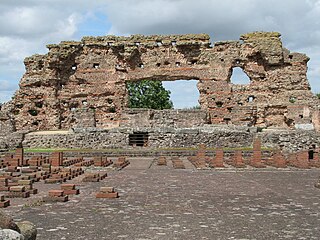
Letocetum is the ancient remains of a Roman settlement. It was an important military staging post and posting station near the junction of Watling Street, the Roman military road to north Wales, and Icknield Street. The site is now within the parish of Wall, Staffordshire, England. It is owned and run by the National Trust, under the name Letocetum Roman Baths Site & Museum. The site is in the guardianship of English Heritage as Wall Roman Site.

Monks Kirby is a village and civil parish in north-eastern Warwickshire, England. The population of the parish is 445. Monks Kirby is located around one mile east of the Fosse Way, around 8 miles north-west of Rugby, seven miles north-east of Coventry and six miles west of Lutterworth. Administratively it forms part of the borough of Rugby. One of the largest and most important villages in this part of Warwickshire in the Anglo-Saxon and later medieval period, the village continued to be a local administrative centre into the early 20th century.
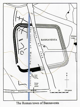
Bannaventa or Benaventa was a Romano-British fortified town which was on the Roman road later called Watling Street, which today is here, as in most places, the A5 road. Bannaventa straddles the boundaries of Norton and Whilton, Northamptonshire, England, villages highly clustered 1 kilometre (0.62 mi) and double that away, respectively.

This is about the history of the County of Warwick situated in the English Midlands. Historically, bounded to the north-west by Staffordshire, by Leicestershire to the north-east, Northamptonshire to the east, Worcestershire to the west, Oxfordshire to the south, Gloucestershire to the south-west, an exclave of Derbyshire to the far north, and less than 400 yards from the border with Shropshire in the far west.

High Cross is the name given to the crossroads of the Roman roads of Watling Street and Fosse Way on the border between Leicestershire and Warwickshire, England. A naturally strategic high point, High Cross was "the central cross roads" of Anglo-Saxon and Roman Britain. It was the site of a Romano-British settlement known as Venonae or Venonis, with an accompanying fort.

Leintwardine is a small to mid-size village and civil parish in north Herefordshire, England, close to the border with Shropshire.

Richborough Castle is a Roman Saxon Shore fort better known as Richborough Roman Fort. It is situated in Richborough near Sandwich, Kent. Substantial remains of the massive fort walls still stand to a height of several metres.

This is about the history of the town of Rugby, Warwickshire, England.
Isurium or Isurium of the Brigantes was a Roman fort and town in the province of Britannia at the site of present-day Aldborough in North Yorkshire, England, in the United Kingdom. Its remains—the Aldborough Roman Site—are in the care of English Heritage.

Clifton-upon-Dunsmore is a village and civil parish in the Rugby borough of Warwickshire in England on the north-eastern outskirts of Rugby, approximately 2 miles (3.2 km) from Rugby town centre. The population of the parish taken at the 2011 census was 1,304, increasing to 2,991 at the 2021 census. Clifton is counted as being part of the Rugby built-up area, but is considered separate from the town. The parish also includes the new development of Houlton to the south of the old village, which may account for the large population increase since 2011.

Cow Roast is a hamlet within the civil parishes of Northchurch and Wigginton in Hertfordshire, England. It is between Tring and Berkhamsted, along the A4251, adjacent to the Grand Union Canal and the West Coast Main Line. Today it comprises a row of 20th-century houses and a marina, together with several older properties including a restaurant. There are three car dealerships and a petrol station beside the main road.
Pennocrucium was a Romano-British settlement and military complex located at present day Water Eaton, just south of Penkridge, Staffordshire, with evidence of occupation from the mid-1st century until the 4th century.

The River Swift is a 14-mile (23 km) long tributary of the River Avon that rises in south Leicestershire, and flows through the town of Lutterworth before joining the Avon at its confluence at Rugby in Warwickshire in the English Midlands.

