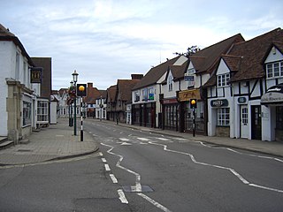
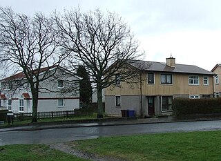
Last updated Houses on Saunton Road on the Overslade estate
Overslade is a residential area in the central south part of the town of Rugby, Warwickshire. The area was developed for housing in the 20th century, mostly between the 1930s and late-1950s. It was historically within the parish of Bilton.[1]
The local council built a large number of prefabricated steel-clad BISF houses in Overslade in the late-1940s to solve a local housing shortage after World War II, which led to the area gaining the nickname of 'tin town', although most of these houses have been refurbished in recent years, with their steel cladding removed or covered. A common misconception exists that these houses were meant to be temporary, however they were in fact designed to have the same lifespan as conventional constructions.[2][3]
The local secondary school is Harris Church of England Academy. There are several parks and open spaces in the neighbourhood, the largest being the long, thin, Burnside Open Space, which runs adjacent to the Sow Brook (a tributary of the River Avon}[4]
At the time of the 2001 census, Overslade was a ward of the borough of Rugby, the ward's population in 2001 was 5,606. By 2016, the ward had its boundaries altered to include the adjacent Rokeby area and had been renamed Rokeby and Overslade which had a population of 7,809.[6]
Romford is a large town in East London and the administrative centre of the London Borough of Havering. It is located 14.1 miles (22.7 km) northeast of Charing Cross and is one of the major metropolitan centres identified in the London Plan. Historically, Romford was a market town in the county of Essex, and it formed the administrative centre of the liberty of Havering before that liberty was dissolved in 1892. Good road links to London and the opening of the railway station in 1839 were key to the development of the town. The economic history of Romford is characterised by a shift from agriculture to light industry and then to retail and commerce. Throughout the 20th century, along with other London suburbs, Romford significantly expanded and increased in population, becoming a municipal borough in 1937. Romford was part of Essex until 1965, when it became part of Greater London. Today, it is one of the largest commercial, retail, entertainment and leisure districts in London and has a well-developed night-time economy as well. Its population, as of 2011, was 122,854.
The London Borough of Havering in East London, England, forms part of Outer London. It has a population of 259,552 inhabitants; the principal town is Romford, while other communities are Hornchurch, Upminster, Collier Row and Rainham. The borough is mainly suburban, with large areas of protected open space. Romford is a major retail and night time entertainment centre, and to the south the borough extends into the London Riverside redevelopment area of the Thames Gateway. The name Havering is a reference to the Royal Liberty of Havering which occupied the area for several centuries. The local authority is Havering London Borough Council. It is the easternmost London borough.
Rugby is a market town in eastern Warwickshire, England, close to the River Avon. In 2020 its population was estimated at 77,285, making it the second-largest town in Warwickshire. It is the main settlement within the larger Borough of Rugby which has a population of 108,935.
The Borough of Rugby is a local government district with borough status in eastern Warwickshire, England. The borough comprises the town of Rugby where the council has its headquarters, and the rural areas surrounding the town. The borough has a population of just over 100,000. Of these, over 70,000 live in the town of Rugby, with the remainder living in the surrounding rural areas.
Knowle is a large village situated 3 miles (5 km) east-southeast of the town of Solihull, West Midlands, England. Knowle lies within the Arden area of the historic county boundaries of Warwickshire, and since 1974 it has been part of the Metropolitan Borough of Solihull within the West Midlands. It lies 2.5 miles from the Warwickshire border and has a population of around 11,000 residents.
The Metropolitan Borough of Dudley is a metropolitan borough of West Midlands, England. It was created in 1974 following the Local Government Act 1972, through a merger of the existing Dudley County Borough with the municipal boroughs of Stourbridge and Halesowen. The borough borders Sandwell to the east, the city of Birmingham to the south east, Bromsgrove to the south in Worcestershire, South Staffordshire District to the west, and the city of Wolverhampton to the north.
Warwick is a local government district of central Warwickshire in England. It borders Rugby Borough and Stratford-on-Avon District in Warwickshire as well as the West Midlands County. The City of Coventry is to the north and northeast, the Stratford-on-Avon District to the southwest and south, the Borough of Rugby to the east, and the Borough of Solihull to the west and northwest.
Quinton, situated in the west of Birmingham, is a ward that is approximately 5 miles from Birmingham city centre. Between the Amber Tavern and Quinton church, the southern side of the Hagley Road is part of the city of Birmingham and the northern side is part of the metropolitan borough of Sandwell. Quinton, along with Bartley Green, Harborne and Edgbaston are a part of the Birmingham Edgbaston constituency. The whole of Quinton is covered by the B32 postal district.
Hillmorton is a suburb of Rugby, Warwickshire, England, around 2 miles (3.2 km) south-east of Rugby town centre, forming much of the eastern half of the town. It is also a ward of the Borough of Rugby. Hillmorton was historically a village in its own right, but was incorporated into Rugby in 1932. Hillmorton also encompasses the Paddox housing estate to the west of the old village, which is shown an many maps as 'Hillmorton Paddox', this area however is part of a separate ward called 'Paddox'.
Rugby and Kenilworth was a county constituency in Warwickshire, England. It returned one Member of Parliament to the House of Commons of the Parliament of the United Kingdom. It existed from 1983 to 2010.
Bilton is a suburb of Rugby in Warwickshire, England, located about 1.5 miles (2.4 km) south-west of Rugby town centre. It is also a ward of the Borough of Rugby, which at the 2011 Census had a population of 6,175. It comprises much of the western half of the town. Historically a village in its own right, Bilton was incorporated into Rugby in 1932.
New Bilton is a suburb of Rugby, Warwickshire, in England, situated to the west of the town centre. New Bilton is also a ward of the Borough of Rugby whose population at the 2011 census was 8,313. The area straddles the A428 main road, known locally as Lawford Road.
Rugby is a constituency represented in the House of Commons of the UK Parliament since its 2010 recreation by Mark Pawsey, a Conservative.
This is about the history of the town of Rugby, Warwickshire, England.
Exhall is a suburban settlement in the Nuneaton and Bedworth district of Warwickshire, England.
Whitestone is a suburban area of Nuneaton in Warwickshire in central England. It is located approximately two miles south-east of Nuneaton town centre. Historically part of Attleborough, the area has developed its own identity following extensive housing developments since the 1950s and 1960s. Today, it is generally considered one of Nuneaton's more desirable areas.
Hawkesbury Village is a settlement in the Nuneaton and Bedworth district of Warwickshire, central England.
Clifton-upon-Dunsmore is a village and civil parish in the Rugby borough of Warwickshire in England on the north-eastern outskirts of Rugby, approximately 2 miles (3.2 km) from Rugby town centre. The population of the parish taken at the 2011 census was 1,304. Clifton is counted as being part of the Rugby built-up area, but is considered separate from the town.
The BISF house is a British steel framed house, designed and produced by the British Iron and Steel Federation, and erected around the country from 1946.
Tin Town is a small suburb in the north-east of Luton. The area is roughly bounded by Moreton Road and Turners Road North to the north, Crawley Green Road to the south, Vauxhall Way to the west, and Ashcroft Road to the east.
This page is based on this Wikipedia article Text is available under the CC BY-SA 4.0 license; additional terms may apply. Images, videos and audio are available under their respective licenses.