 View of the lighthouse | |
 | |
| Location | Agder, Norway |
|---|---|
| Coordinates | 58°06′33″N06°34′00″E / 58.10917°N 6.56667°E |
| Tower | |
| Constructed | 1853 (current) |
| Construction | Granite tower |
| Automated | 2003 |
| Height | 34 metres (112 ft) |
| Shape | Round |
| Markings | Unpainted stone with red and white top |
| Operator | Lista Fyr |
| Heritage | cultural heritage preservation in Norway |
| Racon | Morse code "G" |
| Light | |
| First lit | 1836 (first) |
| Focal height | 39.5 metres (130 ft) |
| Intensity | 1,026,000 candela |
| Range | 17.5 nmi (32.4 km; 20.1 mi) |
| Characteristic | Fl W 4s |
| Norway no. | 086500 |
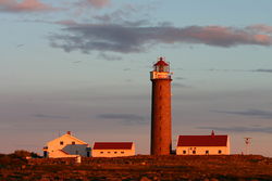
Lista Lighthouse (Norwegian : Lista fyr) is a coastal lighthouse located at the western side of the Lista peninsula, a short distance northwest of the village of Vestbygd in the municipality of Farsund in Agder county, Norway. The lighthouse sits on a cape on the edge of the Listafjorden which marks the extreme southwestern edge of the mainland of Norway. The lighthouse had a foghorn that was used from 1877 until 1987. In 1937, the station began emitting a racon signal of the morse code letter "G". [1]
Contents
The 34-metre (112 ft) tall unpainted granite tower was first lit in 1836, but it was rebuilt in 1853. The light sits at an elevation of 39.5 metres (130 ft) and it emits a white flash of light every four seconds. The 1,026,000-candela light can be seen in all directions for up to 17.5 nautical miles (32.4 km; 20.1 mi). [2] [3]
In 2003, the station was automated and the buildings were turned over to Vest-Agder county. The site is now used as a museum that is open daily during the summer months.


