
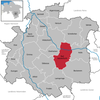
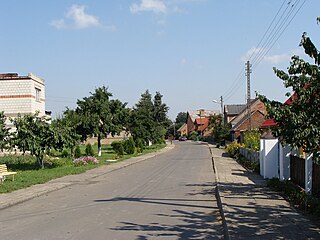
Listringen is a village of the municipality Bad Salzdetfurth in the district of Hildesheim, in Lower Saxony, Germany. It is situated approximately 9 km south of Hildesheim.
Listringen is a village of the municipality Bad Salzdetfurth in the district of Hildesheim, in Lower Saxony, Germany. It is situated approximately 9 km south of Hildesheim.
![]()
Villages of Bad Salzdetfurth | ||
|---|---|---|
Coordinates: 52°6′N10°04′E / 52.100°N 10.067°E
| This Hildesheim district location article is a stub. You can help Wikipedia by expanding it. |
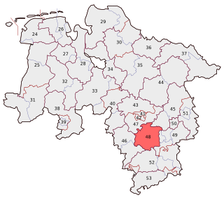
Peine is a district in Lower Saxony, Germany. It is bounded by the districts of Hildesheim, Hanover and Gifhorn, and the cities of Brunswick and Salzgitter.
Hildesheim is a district (Landkreis) in Lower Saxony, Germany. It is bounded by the districts of Hanover, Peine, Wolfenbüttel, Goslar, Northeim, Holzminden and Hamelin-Pyrmont.

The University of Hildesheim emerged from the Teacher's Training University of Lower Saxony.

The Mittelland Canal, also known as the Midland Canal, is a major canal in central Germany. It forms an important link in the waterway network of that country, providing the principal east-west inland waterway connection. Its significance goes beyond Germany as it links France, Switzerland and the Benelux countries with Poland, the Czech Republic and the Baltic Sea.
Bodenburg is a village in Lower Saxony, Germany. It is located about 20 km south of Hildesheim, and about 5 km from Bad Salzdetfurth. The community has a population of 2,000.

Wilczyn is a village in the administrative district of Gmina Biała Podlaska, within Biała Podlaska County, Lublin Voivodeship, in eastern Poland. It lies approximately 6 kilometres (4 mi) north-east of Biała Podlaska and 100 km (62 mi) north-east of the regional capital Lublin.

Kołbiel is a village in Otwock County, Masovian Voivodeship, in east-central Poland. It is the seat of the gmina called Gmina Kołbiel. It lies approximately 16 kilometres (10 mi) east of Otwock and 37 km (23 mi) south-east of Warsaw.
Binkowo is a village in the administrative district of Gmina Śrem, within Śrem County, Greater Poland Voivodeship, in west-central Poland. It lies approximately 6 kilometres (4 mi) east of Śrem and 40 km (25 mi) south of the regional capital Poznań.
Pysząca is a village in the administrative district of Gmina Śrem, within Śrem County, Greater Poland Voivodeship, in west-central Poland. It lies approximately 4 kilometres (2 mi) south-east of Śrem and 39 km (24 mi) south of the regional capital Poznań.
Żelice is a village in the administrative district of Gmina Wągrowiec, within Wągrowiec County, Greater Poland Voivodeship, in west-central Poland. It lies approximately 10 kilometres (6 mi) west of Wągrowiec and 48 km (30 mi) north of the regional capital Poznań.

Bogdaniec is a village in Gorzów County, Lubusz Voivodeship, in western Poland. It is the seat of the gmina called Gmina Bogdaniec. It lies approximately 14 km (9 mi) south-west of Gorzów Wielkopolski.
Czetowice is a village in the administrative district of Gmina Krosno Odrzańskie, within Krosno Odrzańskie County, Lubusz Voivodeship, in western Poland. It lies approximately 8 kilometres (5 mi) north of Krosno Odrzańskie, 35 km (22 mi) north-west of Zielona Góra, and 72 km (45 mi) south of Gorzów Wielkopolski.
The Hildesheim Börde is a natural region, 272 km2 in area, in the northern part of Hildesheim district, which is known for its especially rich black earth loess soil.
The Innerste Uplands is a landscape region up to 359 m high and covering an area of over 900 km² in the northern part of the German Central Uplands. It lies within the eastern part of the Weser-Leine Uplands in Lower Saxony (Germany).
The Hildesheim Forest is a range of hills up to 359 m above sea level (NN) in the district of Hildesheim in the German state of Lower Saxony.
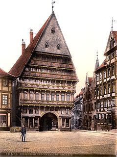
The Butchers' Guild Hall is a half-timbered house in Hildesheim in the federal state of Lower Saxony, Germany.
The Hildesheim loop, also known as the Sorsum curve or the Hildesheim curve, is a 3.7 km long German passenger railway. It is single-track and electrified throughout. The line was opened in 1991.

The 1st Mechanized Infantry Brigade in Hildesheim was a formation in the Bundeswehr, which was subordinated to the 1st Armoured Division in Hanover. The Brigade was disbanded on 31 December 2007. During its lifetime the Brigade was stationed between the Lüneburg Heath, Harz Mountains, the Solling hills and the River Weser.
Hildesheim is one of the 299 single member constituencies used for the German parliament, the Bundestag. One of thirty constituencies in the state of Lower Saxony, it is coterminous with the county of Hildesheim. The constituency elects one representative under the mixed member proportional representation (MMP) system. Under the current constituency numbering system, it is designated as constituency 48.