
Beaver River is a large river in east-central Alberta and central Saskatchewan, Canada. It flows east through Alberta and Saskatchewan and then turns sharply north to flow into Lac Île-à-la-Crosse on the Churchill River which flows into Hudson Bay.
Highway 924, also known as Elaine Lake Road, is a provincial highway in the north-west region of the Canadian province of Saskatchewan. It runs from Highway 55 near Cowan Dam Recreation Site at the source of the Cowan River to the community of Dore Lake on Doré Lake. The highway connects with Highway 916. It is about 64 kilometres (40 mi) long.
Highway 155 is a paved, undivided provincial highway in the Canadian province of Saskatchewan. It runs from Highway 55 near Green Lake until La Loche, where it intersects with Highway 955. The highway services several communities and provincial recreation sites and is entirely within the Northern Saskatchewan Administration District. It is about 299 kilometres (186 mi) long.
Highway 106, also known as the Hanson Lake Road, is a fully paved provincial highway in the Canadian province of Saskatchewan. It runs from Highway 55 at Smeaton to Highway 167 in Creighton. It is about 325 kilometres (202 mi) long and the speed limit is 100 km/h (62 mph).

Dore Lake is a northern hamlet located on the southern shore of South Bay of Doré Lake, which is one of the largest lakes in northern Saskatchewan. Its name is the French word for "walleye". The community is accessed by Highway 924 and by Dore Lake Airport.
Deschambault Lake is a freshwater lake in the north-eastern region of the Canadian province of Saskatchewan. The identically-named community of Deschambault Lake resides on its shore. There are also four Indian reserves on the lake — Kimosom Pwatinahk 203, Mistik Reserve, Pisiwiminiwatim 207, and Muskwaminiwatim 225 — and a provincial recreation site.
Highway 55 is a paved, undivided provincial highway in the Canadian province of Saskatchewan. It runs from the Alberta border west of Pierceland to Highway 9 near Mountain Cabin. Highway 55 is about 652 kilometres (405 mi) long and forms part of the interprovincial Northern Woods and Water Route.

The Rural Municipality of Meadow Lake No. 588 is a rural municipality (RM) in the Canadian province of Saskatchewan within Census Division No. 17 and SARM Division No. 6.

Peter Pond Lake is a glacial lake in the north-western part of the Canadian province of Saskatchewan. It is located in the boreal orest and Canadian Shield within the Churchill River drainage basin.

Amisk Lake is a lake in the east-central part of the Canadian province of Saskatchewan, about 22 kilometres (14 mi) south-west of Flin Flon, Manitoba. 'Amisk' means beaver in Cree. Along the lake's shores is the community of Denare Beach, a provincial recreation site with lake access and camping, and prehistoric limestone crevices. Access to the lake and its amenities is from Highway 167. Amisk Lake was on an important fur trade route in the 18th century.
Cowan Lake is a lake in the Canadian province of Saskatchewan in the Beaver River watershed. The primary inflow for the lake is Big River at the lake's southern end by the town of Big River and the outflow, located near the lake's northern end, is Cowan River at Cowan Lake Dam. The dam was originally built in 1937 and was upgraded in 1971. It is 4.2 metres (14 ft) high and the total volume of the reservoir created by the dam is 40,334 dam3 (32,699 acre⋅ft).
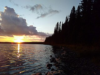
Doré Lake is a lake in the Canadian province of Saskatchewan in the basin of the Beaver River. Doré is the French Canadian term for 'walleye'. The lake is north-west of Smoothstone Lake and the Waskesiu Upland in the Mid-Boreal Upland ecozone of Canada and is surrounded by boreal forests. Saskatoon, Saskatchewan's largest city, is about 328 kilometres (204 mi) to the south. The northern village of Dore Lake is located on South Bay and is accessed from Highway 924 and Dore Lake Airport.

Narrow Hills Provincial Park is a northern boreal forest provincial recreational park in the Canadian province of Saskatchewan. It is located in a hilly plateau called the Cub Hills and contains several recreational facilities and over 25 accessible lakes within its boundaries. The geographical features of the park, including the lakes, valleys, and lowlands were formed over 10,000 years ago during the last ice age. The town of Smeaton is the closest community and it is located 70 kilometres (43 mi) to the south.
Lac Île-à-la-Crosse is a Y-shaped lake in the north-central region of the Canadian province of Saskatchewan along the course of the Churchill River. At the centre of the "Y" is the town of Île-à-la-Crosse, the second oldest town in Saskatchewan. Situated at the confluence of the Churchill and Beaver Rivers, the lake was an important fur trading centre in the 18th and 19th centuries. The lake, and the community of Île-à-la-Crosse, are named after the game of Lacrosse as French voyageurs had witnessed local Indians playing the game on an island in the lake.
Lac la Plonge is a glacial lake in the Canadian province of Saskatchewan in the basin of the Beaver River, near Lac Île-à-la-Crosse. It is located in the boreal forest near the Canadian Shield. On the lake's northern shore, the community of Lac La Plonge, a resort, and campgrounds are accessed via Highway 165.
Porcupine Hills Provincial Park is the newest provincial park in the Canadian Province of Saskatchewan. It was created in 2018 through the amalgamation of five pre-existing provincial recreation sites south-east of the town of Hudson Bay. The park is in the Porcupine Provincial Forest in the Porcupine Hills, which is a geographical feature in eastern Saskatchewan and western Manitoba. The hills are part of a range of hills called the Manitoba Escarpment.

Cowan River is a river in the west-central part of the Canadian province of Saskatchewan in the boreal forest ecozone of Canada. The river begins at Cowan Lake Dam near the northern end of Cowan Lake and flows north-west through muskeg and forest to meet Beaver River. Beaver River then flows into Lac Île-à-la-Crosse and the Churchill River. The entirety of Cowen River is within the Northern Saskatchewan Administration District and while there are no communities along its course, the towns of Big River and Spiritwood are in its watershed.
Big Shell Lake is a lake in the Canadian province of Saskatchewan. Officially known as Shell Lake, it is commonly called Big Shell Lake to differentiate it from Little Shell Lake, which is about 4.5 kilometres (2.8 mi) downstream. Big Shell Lake is in the RM of Spiritwood No. 496 and the resort villages of Big Shell and Echo Bay are on the south-eastern and eastern shore. Access to the lake and the villages is from Highway 12.
Chitek Lake is lake in the Canadian province of Saskatchewan. It is in the Mid-boreal Upland ecozone in the west-central part of Saskatchewan. Most of the lake is the RM of Big River No. 555 and only the very southernmost point is in the RM of Spiritwood No. 496. Along the lake's shores, there is the Chitek Lake Indian reserve, a community, provincial recreation area, resorts, and outfitters. The outflow is the Chitek River, which flows out from the northern end of the lake. Access is from Highway 24.
Little Amyot Lake is a lake in the Canadian province of Saskatchewan. It is situated in the Churchill River Upland ecozone surrounded by muskeg and boreal forest. The lake is in the Northern Saskatchewan Administration District near the southern tip of South Bay of Lac Île-à-la-Crosse. At the eastern end of Little Amyot Lake is the community of Little Amyot Lake and a provincial recreation site. Access is from Highway 155.
