
South Andaman Island is the southernmost island of the Great Andaman and is home to the majority of the population of the Andaman Islands. It belongs to the South Andaman administrative district, part of the Indian union territory of Andaman and Nicobar Islands. It is the location of Port Blair, capital of the Andaman and Nicobar Islands.
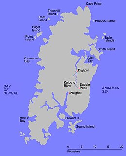
North Andaman Island is the northern island of Great Andaman of the Andaman Islands. It belongs to the North and Middle Andaman administrative district, part of the Indian union territory of Andaman and Nicobar Islands. the island is lying 137 km (85 mi) north from Port Blair.
Little Andaman Island is the fourth largest of the Andaman Islands of India with an area of 707 km², lying at the southern end of the archipelago. It belongs to the South Andaman administrative district, part of the Indian union territory of Andaman and Nicobar Islands. It lies 88 km (55 mi) south of Port Blair, the capital of Andaman and Nicobar Islands.
Middle Andaman Island is an island of the Andaman Islands. It belongs to the North and Middle Andaman administrative district, part of the Indian union territory of Andaman and Nicobar Islands.
Great Andaman is the main archipelago of the Andaman Islands of India. It comprises seven major islands. From north to south, these are North Andaman, Interview Island, Middle Andaman, Long Island, Baratang Island, South Andaman, and Rutland Island.
Rutland Island is an island of the Andaman Islands. It belongs to the South Andaman administrative district, part of the Indian union territory of Andaman and Nicobar Islands. the island lies 20 km (12 mi) south from Port Blair.
South Sentinel Island is one of the Andaman Islands in the Bay of Bengal. It is 1.6 km (0.99 mi) long northeast to southwest and up to 1 km (0.62 mi) wide. At only 1.61 km2 (0.62 sq mi), it is much smaller than its counterpart North Sentinel Island and is currently uninhabited. The island belongs to the Port Blair tehsil in the South Andaman administrative district, part of the Indian union territory of Andaman and Nicobar Islands, neighbouring North Sentinel Island.
Henry Lawrence Island is an island of the Andaman Islands. It belongs to the South Andaman administrative district, part of the Indian union territory of Andaman and Nicobar Islands. the island is located 60 km (37 mi) northeast of Port Blair.
Interview Island is an island of the Andaman Islands. It belongs to the North and Middle Andaman administrative district, part of the Indian union territory of Andaman and Nicobar Islands. It lies 125 km (78 mi) north of Port Blair.
Sister Islands are a group of uninhabited islands of the Andaman Islands. They belong to the South Andaman administrative district, part of the Indian union territory of Andaman and Nicobar Islands. the island is lying 57 km (35 mi) south from Port Blair.
Smith Island is an island of the Andaman Islands. It belongs to the North and Middle Andaman administrative district, part of the Indian union territory of Andaman and Nicobar Islands. The island lies 298 km (185 mi) north of Port Blair.
The Aerial Bay Islands are a group of islands in Aerial Bay in the Andaman Islands. This group belongs to the North and Middle Andaman administrative district, part of the Indian union territory of Andaman and Nicobar Islands. Smith Island is the largest and only inhabited one.
The Interview Islands is a group of islands located in Austin Harbour and Interview sound. These islands belong to the Andaman Islands. They belong to the North and Middle Andaman administrative district, part of the Indian union territory of Andaman and Nicobar Islands.
Spike Island is an island of the Andaman Islands. It belongs to the North and Middle Andaman administrative district, part of the Indian union territory of Andaman and Nicobar Islands. The island lies 63 km (39 mi) north from Port Blair.
North Passage Island is an island of the Andaman Islands. It belongs to the North and Middle Andaman administrative district, part of the Indian union territory of Andaman and Nicobar Islands. The island lies 80 km (50 mi) north from Port Blair.
Kyd Island is an island of the Andaman Islands. It belongs to the South Andaman administrative district, part of the Indian union territory of Andaman and Nicobar Islands. the island lies 30 km (19 mi) north from Port Blair.
Napier Bay Islands is a group of islands of the Andaman Islands. It belongs to the South Andaman administrative district, part of the Indian union territory of Andaman and Nicobar Islands. The islands are 30 km (19 mi) north of Port Blair.
Passage Island or Duncan Island is an uninhabited island of the Andaman Islands. It belongs to the South Andaman administrative district, part of the Indian union territory of Andaman and Nicobar Islands. The island is 53 km (33 mi) south from Port Blair.
North and South Brother Islands are uninhabited islands in the Indian Ocean, part of the Andaman Archipelago. They belong to the South Andaman administrative district, part of the Indian union territory of Andaman and Nicobar Islands. the island is lying 75 km (47 mi) south from Port Blair.
Nicholson Island is an island of the Andaman Islands. It belongs to the South Andaman administrative district, part of the Indian union territory of Andaman and Nicobar Islands. the island is lying 52 km (32 mi) northeast from Port Blair.


