
Honington is a village and civil parish located in Bardwell Ward and Pakenham and Troston Wards of West Suffolk District Council, Suffolk in eastern England It is near to the border with Norfolk. It lies on the River Black Bourn, about 8 miles (13 km) from Bury St Edmunds and 6 miles (10 km) from Thetford, Norfolk. Much of the farmland belongs to the estate of the Duke of Grafton. The village is known for its RAF station, RAF Honington. It is also near two joint RAF/USAF airfields: RAF Lakenheath and RAF Mildenhall. Honington was the birthplace of the poet Robert Bloomfield. In 2011 the parish had a population of 1472.
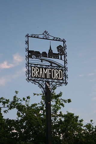
Bramford is a village in the Mid Suffolk district of Suffolk, England. It is three miles west of Ipswich of which it forms part of the wider Ipswich Built-up area. It was recorded in the Domesday Book as "Brunfort" or "Branfort". The River Gipping, runs at the bottom of the village and was a busy navigable waterway during the 19th century. A lock is still on the east of side of the village. The village has two churches; in the north west of the village on the B1067 road. Bramford railway station was originally on the Eastern Union Railway but closed in 1955.

Ecclesfield is a village and civil parish in the City of Sheffield, South Yorkshire, England, about 4 miles (6 km) north of Sheffield City Centre. Ecclesfield civil parish had a population of 32,073 at the 2011 Census. Ecclesfield wards of the City of Sheffield had a population of 35,994 in 2011. The population of Ecclesfield village stood at 7,163 in the most recent census.
Hemingstone is a village and civil parish in the Mid Suffolk district of Suffolk in eastern England located 6.5 miles (11 km) north of Ipswich.
Sapiston is a small village and civil parish in the West Suffolk district of Suffolk in eastern England, located near the Suffolk-Norfolk border. It is in northern Suffolk lying on the river Blackbourn. The place-name 'Sapiston' is first attested in the Domesday Book of 1086, where it appears as Sapestuna. The name is thought to mean 'village of soapmakers', but this is not certain.

Baylham is a village and civil parish, 1,349 acres size, in the Mid Suffolk district of Suffolk, England, about 7 miles (11 km) northwest of Ipswich and 6 miles (9.7 km) southeast of Stowmarket.

Sotterley, originally Southern-lea from its situation south of the river, is a village and civil parish in the East Suffolk district, in the English county of Suffolk, located approximately 4 miles (6 km) south-east of Beccles and 1.5 miles (2 km) east of Willingham St Mary and Shadingfield. The parish is primarily agricultural with a dispersed population of 113 at the 2011 census. The parish council operates to administer jointly the parishes of Shadingfield, Willingham St Mary, Sotterley and Ellough.
Kirby Cane is a scattered village and civil parish centred 3.8 miles (6.1 km) west northwest of Beccles and 2.7 miles (4.3 km) northeast of Bungay. It is in south-east Norfolk. It housed 375 people in 152 households as at 2001 – then 434 in 179 households at the 2011 Census, the increase in households being almost 18% – unusually large for England. Its north-eastern neighbourhood is often known as Kirby Green. The most populous part is often known as Kirby Row, which is 0.3 miles (0.48 km) from the heart of Ellingham, Norfolk and which is, narrowly, mainly in that parish – whether taken in its historical borders or on its similar boundaries of today. The land drains gently south to the Waveney which is the border with Suffolk.

Honing is a village and a civil parish in the English county of Norfolk. It is located 15 miles (24 km) north-north-east of Norwich, 13 miles (21 km) south-east of Cromer and 4 miles (6.4 km) east of North Walsham. The parish of Honing, which includes Crostwight, had a population of 319 in the 2001 census, but this fell to 312 at the 2011 Census. The village is part of the district of North Norfolk.

Woodmancote is a village and civil parish in the Horsham District of West Sussex, England. The village is 1 mile (1.5 km) southeast of Henfield on the A281 road. It should not be confused with the other West Sussex village of Woodmancote near Chichester.

Little Cornard is a village and civil parish in Suffolk, England. Located around 0.5 miles (0.8 km) from its larger sibling, Great Cornard, on the B1508 road between Sudbury and Colchester, it is part of Babergh district, and has a population of 305, reducing to 286 at the 2011 Census. The parish also includes the hamlet of Workhouse Green.

Great Wratting is a village and civil parish in England, about four miles from Haverhill, Suffolk, in the valley of the River Stour. There is a ford across the Stour in the centre of the village, where bathing and fishing are common pursuits. The river here is heavily populated by crayfish, a non native species long since escaped from farms near the mouth of the Stour.

Nettlestead is a dispersed village and civil parish in the Mid Suffolk district of Suffolk in eastern England.The surrounding villages of Nettlestead include Somersham, Little Blakenham, Baylham, Barking, Willisham and Offton.

Little Stonham, also known as Stonham Parva, is a village and civil parish in the Mid Suffolk district of Suffolk in eastern England. Located just off the A140, around three miles east of Stowmarket, in 2005 its population was 350.
Chedburgh is a village and civil parish in the West Suffolk district of Suffolk in eastern England. Located on the A143 around five miles south-west of Bury St Edmunds, in 2005 its population was 650, reducing to 597 at the 2011 Census.

Euston is a village and civil parish in the West Suffolk district of Suffolk in eastern England, on the A1088 two miles south of Thetford.

Little Whelnetham (well-NEE-thum) is a village and civil parish in the West Suffolk district of Suffolk in eastern England. Located around two miles south of Bury St Edmunds, in 2005 its population was 180.

Great Thurlow is a village and civil parish in the West Suffolk district of Suffolk in eastern England. It is situated in the far south-west of Suffolk, with the River Stour passing through the centre of the village.
Hawkedon is a village and civil parish in the West Suffolk district of Suffolk in eastern England. Located around 7 miles (11 km) south-south-west of Bury St Edmunds, the parish also contains the hamlet of Thurston End, and in 2005 had a population of 120. The majority of the village is classed as a conservation area.

Lackford is a village and civil parish in the West Suffolk district of Suffolk in eastern England. Located around four miles north-west of Bury St Edmunds on the A1101, in 2005 it had a population of 270.

