The Elk River is a 35.2-mile-long (56.6 km) tributary of the Neosho River in southwestern Missouri and northeastern Oklahoma in the United States. Its tributaries also drain a small portion of northwestern Arkansas. Via the Neosho and Arkansas rivers, the Elk is part of the Mississippi River watershed.

The Bohemia River is a 4.7-mile-long (7.6 km) tributary of the Elk River on the Delmarva Peninsula. It is located in Cecil County, Maryland, with its headwaters extending into New Castle County, Delaware.

The Elk River is a tidal tributary of the Chesapeake Bay on the Eastern Shore of Maryland and on the northern edge of the Delmarva Peninsula. It is about 15 miles (24 km) long. As the most northeastern extension of the Chesapeake Bay estuary, it has served as one entrance to the Chesapeake & Delaware Canal since the 19th century. The canal and river now serve as one boundary of the Elk Neck Peninsula. The river flows through Cecil County, Maryland, with its watershed extending into New Castle County, Delaware and Chester County, Pennsylvania. Elkton, the county seat of Cecil County, is located at its head. Its total watershed area is 143 square miles (370 km2), with 21 square miles (54 km2) of open water, so its watershed is 15% open water. It is south and east of the North East River, and north of the Sassafras River.
East Sandy Creek is a tributary of the Allegheny River in Northwestern Pennsylvania in the United States.

Black Moshannon Creek is a 22.9-mile-long (36.9 km) tributary of Moshannon Creek in Centre County, Pennsylvania in the United States.
Elk Creek is a 30.4-mile (48.9 km) tributary of Lake Erie in Erie County, Pennsylvania in the United States. The creek is part of the Lake Erie Watershed and has a drainage basin of 99.4 square miles (257 km2). Elk Creek is stocked with brown trout and steelhead by the Pennsylvania Fish and Boat Commission.

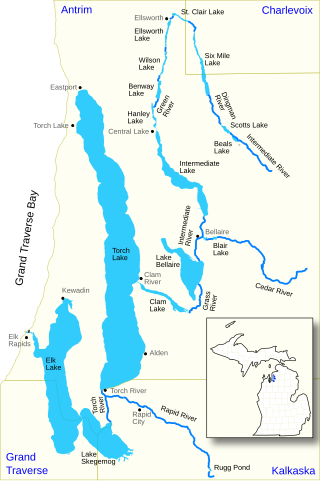
The Elk River Chain of Lakes Watershed, commonly known as the Chain of Lakes, is a 75-mile-long (121 km) waterway consisting of 14 lakes and connecting rivers in the northwestern section of the Lower Peninsula of the U.S. state of Michigan, which empty into Lake Michigan.

The Bridge Creek Wildlife Area is a wildlife management area located near Ukiah, Oregon, United States. The location was set aside in 1961 as a wintering area for elk.

The Dean Creek Wildlife Area is a wildlife management area located near Reedsport, Oregon, United States. Jointly managed by the Oregon Department of Fish and Wildlife and the United States Bureau of Land Management, it is the year-round residence for a herd of Roosevelt elk.

Snake Mountain is a mountain located along the border of North Carolina and Tennessee, east of the community of Zionville, in the southeastern United States. It is part of the Blue Ridge Mountains, and includes parts of Watauga County, North Carolina, and Johnson County, Tennessee. It has two peaks, the higher of which reaches an elevation of 5,564 feet (1,696 m). The lower peak, at 5,518 feet (1,682 m), is Johnson County's high point.
Elk Knob is a mountain in the North Carolina High Country, north of the community of Meat Camp. Its elevation reaches 5,538 feet (1,688 m).
The Pennsylvania State Game Lands Number 25 are Pennsylvania State Game Lands in Elk County in Pennsylvania in the United States providing hunting, bird watching, and other activities.
The Pennsylvania State Game Lands Number 28 are Pennsylvania State Game Lands in Elk, Forest and Jefferson Counties in Pennsylvania in the United States providing hunting, bird watching, and other activities.

Washington District, formerly Washington Magisterial District, is one of five historic magisterial districts in Jackson County, West Virginia, United States. The district was originally established as one of five civil townships in Jackson County after West Virginia became a state in 1863; in 1872, all of West Virginia's townships were converted into magisterial districts. When Jackson County was redistricted in the 1990s, Washington District was combined with the eastern portion of Ripley District, including the city of Ripley, to form the new Eastern Magisterial District. However, the county's historic magisterial districts continue to exist in the form of tax districts, serving all of their former administrative functions except for the election of county officials.

The Eastern Magisterial District is one of three magisterial districts in Jackson County, West Virginia, United States. It was established during a process of redistricting undertaken in the 1990s. In 2010, 9,882 people lived in the district.


