
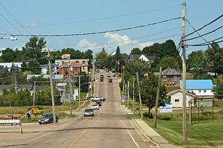
Sackville is a community in southeastern New Brunswick, Canada. It held town status prior to 2023.

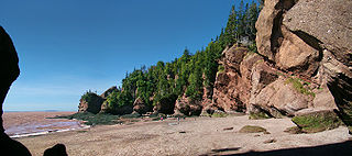
Chignecto Bay is an inlet of the Bay of Fundy located between the Canadian provinces of New Brunswick and Nova Scotia and separated from the waters of the Northumberland Strait by the Isthmus of Chignecto. It is a unit within the greater Gulf of Maine Watershed. Chignecto Bay forms the northeastern part of the Bay of Fundy which splits at Cape Chignecto and is delineated on the New Brunswick side by Martin Head. Chignecto bay was also the site of an unsuccessful railway and canal project of the 1880s and 1890s that would have intersected the landmass, thereby providing a transit passage between New England and Prince Edward Island. After several investigations into the feasibility of a new canal project, including most importantly by the Chignecto Canal Commission, the proposed Chignecto Canal was deemed commercially and economically unjustifiable and the project was abandoned. Some of the physical remnants of the 1880s project still continue to dot the landscape of Chignecto Bay today.
New Maryland is a suburban bedroom village of Fredericton in central New Brunswick, Canada; located directly south of Fredericton, south of Route 2 and Route 101. As of 2021, the population was 4,153, which means it is large enough to become a "town". New Maryland is one of the wealthiest communities in New Brunswick as it has a median household income of over $110,000, the highest of any municipality in the province.
Pemberton Ridge is a rural community in North Lake Parish, York County, New Brunswick, Canada.
Hillsborough is an unincorporated community in Albert County in the province of New Brunswick, Canada. It held village status prior to 2023. Hillsborough is on a hill overlooking the Petitcodiac River near the intersection of Route 910 and Route 114. It is the largest settlement in Hillsborough Parish.
Keswick Ridge is a Canadian rural community in York County, New Brunswick on Route 616.
Hopewell Cape is a Canadian village and headland in Albert County, New Brunswick at the northern end of Shepody Bay and the mouth of the Petitcodiac River.
Aulac is a Canadian community in Westmorland County, New Brunswick. It is located between the college town of Sackville and the provincial border with Nova Scotia.
Fort Lawrence is a Canadian rural community located on the Isthmus of Chignecto in Cumberland County, Nova Scotia, which is named after Fort Lawrence.
Hebron is a small community in Albert County overlooking the Bay of Fundy in the Canadian province of New Brunswick.
Mount Whatley is a community in the Canadian province of New Brunswick, located in Westmorland County on New Brunswick Highway 16. Mount Whatley is situated upon the Aulac Ridge, a prominent rise running west–east across the Tantramar Marshes on the Isthmus of Chignecto,on the shore of the Missaguash River which forms the southern part of the inter-provincial boundary with Nova Scotia.The community is linked by a small bridge to Fort Lawrence Nova Scotia.

Sackville is a civil parish in Westmorland County, New Brunswick, Canada.

Waterside is a Canadian community just outside Alma, New Brunswick on The Bay of Fundy. It has a population of almost 100, with summer cottages along the shore. It is near Cape Enrage, a popular tourist destination and a lighthouse.
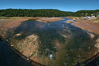
The Upper Salmon River divides Fundy National Park and the village of Alma, New Brunswick at its delta. Here, it is inundated with tidal water from the Salisbury Bay a kilometer to the site of a former dam, making for a large estuary and inter-tidal zone. Its watershed catchment drains a large area in and outside the park, made up of tributaries and their sub-units including Kinnie Brook, Laverty, Forty-five River, Lake Brook, Greenough Brook, and others.

Gordon is a civil parish in Victoria County, New Brunswick, Canada.

Kent is a civil parish in the northeastern corner of Carleton County, New Brunswick, Canada. It comprises one village, two local service districts, and part of one town, all of which are members of the Western Valley Regional Service Commission (WVRSC).

Canterbury is a civil parish in York County, New Brunswick, Canada.

Manners Sutton is a civil parish in York County, New Brunswick, Canada.
Turtle Creek is a community Southwest of Riverview, in Albert County, New Brunswick. The community is located on named after the Turtle Creek and is located on Route 910.

Dumbarton is a civil parish in Charlotte County, New Brunswick, Canada, located inland north of St. George and south of Harvey. It comprises a single local service district (LSD), which is a member of the Southwest New Brunswick Service Commission (SNBSC).
