Riverside-Albert, New Brunswick

Last updated

Riverside-Albert
RiversideAlbertStation 2011.jpg
Former train station in Riverside-Albert
Canada New Brunswick location map 2.svg
Red pog.svg
Riverside-Albert
Location of Riverside-Albert, New Brunswick
Coordinates: 45°45′5.1″N64°43′3.6″W / 45.751417°N 64.717667°W / 45.751417; -64.717667
CountryCanada
Province New Brunswick
County Albert County
Parish Hopewell Parish
Municipality Fundy Albert
Incorporated1966
Amalgamated2023
Government
  Type Village council
Area
[1]
  Land3.39 km2 (1.31 sq mi)
Population
 (2021) [1]
  Total348
  Density102.8/km2 (266/sq mi)
  Change (2016–21)
Decrease2.svg 0.6%
Electoral districts
   Federal Fundy Royal
   Provincial Albert
Time zone UTC-4 (Atlantic (AST))
  Summer (DST) UTC-3 (Atlantic (ADT))
Canadian Postal code
E4H
Area code(s) 506, 428
Telephone Exchange882
HighwayNB 114.svg Route 114
NB 915.svg Route 915
Website http://www.riverside-albert.ca

Riverside-Albert is a former village in Hopewell Parish of Albert County, New Brunswick, Canada. It was an incorporated village until the end of 2022 and is now part of the village of Fundy Albert.

Contents

Riverside-Albert is located on the Shepody River at the edge of the Shepody Marsh. The community of Harvey Parish is located across the river. It is approximately halfway between two major tourist destinations: Fundy National Park and the Hopewell Rocks.

Post office called Albert from 1875; Riverside from 1875 to 1932; Riverside from 1932.

The Trans Canada Trail passes through Riverside-Albert. [2]

History

Riverside and Albert both appear as communities on the cadastral land grant map of the area. [3]

Albert was originally called Hopewell Hill but the inhabitants resolved to rename it Albert in 1881 due to there being four communities named Hopewell within 12 miles of each other. In 1898 Albert was the terminus of the Salisbury and Harvey Railway, with a population of 500. [4]

Riverside, originally River Side, was a station on the Salisbury and Hillsborough Railway, with a population of 300 in 1871. The post office was renamed Riverside in 1932. [5]

The local improvement district of Riverside-Albert was incorporated on 29 December 1947. [6] The local improvement district became a village in 1966 under the new Municipalities Act. [7] [8]

On 1 January 2023, the village of Riverside-Albert amalgamated with the villages of Alma and Hillsborough and parts of five local service districts to form the new village of Fundy Albert. [9] [10] The community's name remains in official use. [11]

Demographics

In the 2021 Census of Population conducted by Statistics Canada, Riverside-Albert had a population of 348 living in 142 of its 154 total private dwellings, a change of

Notable people

Notable residents have included Abner Reid McClelan and Roscoe Fillmore.

See also

Related Research Articles

<span class="mw-page-title-main">Bay of Fundy</span> Bay on the east coast of North America

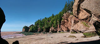
The Bay of Fundy is a bay between the Canadian provinces of New Brunswick and Nova Scotia, with a small portion touching the U.S. state of Maine. It is an arm of the Gulf of Maine. Its tidal range is the highest in the world. The name is probably a corruption of the French word fendu, meaning 'split'.

<span class="mw-page-title-main">Albert County, New Brunswick</span> County in New Brunswick, Canada

Albert County is New Brunswick's third-youngest county located on the Western side of the Petitcodiac River on the Chignecto Bay in the Bay of Fundy. Prior to the abolition of county government in 1967, the shire town was Hopewell Cape. The county was established in 1845 from parts of Westmorland County and Saint John County, and named after Prince Albert.

<span class="mw-page-title-main">Hillsborough, New Brunswick</span> Place in New Brunswick, Canada

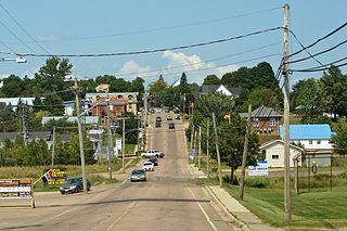
Hillsborough is a former village in Albert County in the province of New Brunswick, Canada. It was an incorporated village prior to 2023 but is now part of the much larger incorporated village of Fundy Albert.

<span class="mw-page-title-main">Alma, New Brunswick</span> Place in New Brunswick, Canada

Alma is a former village in the parish of Alma, Albert County, New Brunswick, Canada. It held village status prior to 2023, when it became part of the new village of Fundy Albert. Alma is centered on the small delta of the Upper Salmon River and Cleveland Brook, where they empty into Salisbury Bay.

Route 114 is a 137.6 km (85.5 mi) Canadian secondary highway in southeastern New Brunswick.

<span class="mw-page-title-main">Hopewell Cape, New Brunswick</span> Village in New Brunswick, Canada

Hopewell Cape is a Canadian village and headland in Albert County, New Brunswick at the northern end of Shepody Bay and the mouth of the Petitcodiac River.

Harvey is a Canadian rural community in Albert County, New Brunswick. Harvey has a wharf, and is situated on Shepody Bay, an arm of the Bay of Fundy. It has a population of about 150, and is about 50 minutes from Moncton. The village of Riverside-Albert is nearby.

Shepody Bay is a tidal embayment, an extension of the Bay of Fundy in New Brunswick, Canada, which consists of 77 square kilometres (30 sq mi) of open water and 40 km2 (15 sq mi) of mudflats, with 4 km2 (1.5 sq mi) of saline marsh on the west, and eroding sand and gravel beaches covering an area of approximately 1 km2 (0.39 sq mi) on the eastern shore. The intertidal mudflats "support internationally important numbers of the crustacean Corophium volutator, the principal food source for millions of fall migrating shorebirds".

<span class="mw-page-title-main">Coverdale Parish, New Brunswick</span> Parish in New Brunswick, Canada

Coverdale is a civil parish in Albert County, New Brunswick, Canada, located along the Petitcodiac River opposite Moncton and Dieppe.

<span class="mw-page-title-main">Mary's Point</span> Wetland in Albert County, New Brunswick, Canada

Mary's Point is a 12 square kilometres (4.6 sq mi) wetland in Albert County, New Brunswick, Canada. It is at the head of the Bay of Fundy, just outside the small community of Harvey and approximately 40 km (25 mi) south of Moncton. Designated a Ramsar wetland of international importance on May 24, 1982, it is also part of the Fundy biosphere reserve established in 2007, which also contains the Shepody Bay wetland. It was also the first Canadian site in the Western Hemisphere Shorebird Reserve, as part of the Bay of Fundy Hemisphere Shorebird Reserve. It is within the Shepody Bay National Wildlife Area, which is administered by the Canadian Wildlife Service.

<span class="mw-page-title-main">Hillsborough Parish, New Brunswick</span> Parish in New Brunswick, Canada

Hillsborough is a civil parish in eastern Albert County, New Brunswick, Canada.

<span class="mw-page-title-main">Elgin Parish, New Brunswick</span> Parish in New Brunswick, Canada

Elgin is a civil parish in the interior of Albert County, New Brunswick, Canada, the only one of the county's parishes that does not border either the Bay of Fundy or the Petitcodiac River.

<span class="mw-page-title-main">Hopewell Parish, New Brunswick</span> Parish in New Brunswick, Canada

Hopewell is a civil parish in eastern Albert County, New Brunswick, Canada.

<span class="mw-page-title-main">Harvey Parish, New Brunswick</span> Parish in New Brunswick, Canada

Harvey is a civil parish in southern Albert County, New Brunswick, Canada.

<span class="mw-page-title-main">Alma Parish, New Brunswick</span> Parish in New Brunswick, Canada

Alma is a civil parish on the Bay of Fundy in the southwestern corner of Albert County, New Brunswick, Canada.

<span class="mw-page-title-main">Salisbury Parish, New Brunswick</span> Parish in New Brunswick, Canada

Salisbury is a civil parish in Westmorland County, New Brunswick, Canada.

<span class="mw-page-title-main">Saint Martins Parish, New Brunswick</span> Parish in New Brunswick, Canada

Saint Martins is a civil parish in Saint John County, New Brunswick, Canada.

<span class="mw-page-title-main">Administrative divisions of New Brunswick</span> Local governance in New Brunswick

The Canadian province of New Brunswick is divided into 89 local entities, consisting of 77 local governments and 12 rural districts.

<span class="mw-page-title-main">Fundy Albert</span> Village in New Brunswick, Canada

Fundy Albert is a village in the Canadian province of New Brunswick created by the consolidation of the former villages of Alma, Riverside-Albert and Hillsborough as well as the concurrent annexation of adjacent unincorporated areas.

References

  1. 1 2 3 "Census Profile of Riverside-Albert, Village (VL)". Statistics Canada. 6 December 2022. Retrieved 21 January 2023.
  2. Sentier NB Trails
  3. "No. 143". Provincial Archives of New Brunswick. Retrieved 1 April 2023.
  4. "Albert". Provincial Archives of New Brunswick. Retrieved 1 April 2023.
  5. "Riverside-Albert". Provincial Archives of New Brunswick. Retrieved 1 April 2023.
  6. "Local Improvement Districts". The Royal Gazette. 106: 48–49. 4 February 1948.
  7. Municipalities Act of 1966, Second Schedule, p. 151.
  8. Hamilton, William (1978). The Macmillan Book of Canadian Place Names. Toronto: Macmillan. p. 84. ISBN   0-7715-9754-1.
  9. "Local Governments Establishment Regulation – Local Governance Act". Government of New Brunswick. 12 October 2022. Retrieved 21 January 2023.
  10. "RSC 7 Southeast Regional Service Commission". Government of New Brunswick. Retrieved 21 January 2023.
  11. "Proposed entity names reflect strong ties to nature and history" (Press release). Irishtown, New Brunswick: Government of New Brunswick. 25 May 2022. Retrieved 21 January 2023.