Hillsborough, New Brunswick

Last updated

Hillsborough
Hillsborough NB.JPG
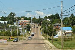
Main Street (Route 114) looking north
Hillsborough NB seal.png
Canada New Brunswick location map 2.svg
Red pog.svg
Hillsborough
Location of Hillsborough, New Brunswick
Coordinates: 45°55′22″N64°38′43″W / 45.92277°N 64.64523°W / 45.92277; -64.64523
CountryCanada
Province New Brunswick
County Albert County
Parish Hillsborough Parish
Municipality Fundy Albert
Founded1700s
Incorporated Village1966
Area
[1]
  Total12.81 km2 (4.95 sq mi)
  Land12.81 km2 (4.95 sq mi)
Population
 (2021) [1]
  Total1,348
  Density105.2/km2 (272/sq mi)
  Change (2016–21)
Increase2.svg 5.6%
Time zone UTC-4 (Atlantic (AST))
  Summer (DST) UTC-3 (Atlantic (ADT))
Canadian Postal code
E
Area code 506
Telephone Exchange203 734
HighwayNB 114.svg Route 114
NB 910.svg Route 910
Website villageofhillsborough.ca

Hillsborough is a former village in Albert County in the province of New Brunswick, Canada. It was an incorporated village prior to 2023 but is now part of the much larger incorporated village of Fundy Albert.

Contents

Hillsborough is on a hill overlooking the Petitcodiac River near the intersection of Route 910 and Route 114. It is the largest settlement in Hillsborough Parish.

History

Originally established around 1700 as "Blanchard's Village" by Acadian farmers, they lived here for sixty years, building dykes that are still in use. Before the Great Expulsion of the Acadians in 1755, the area was almost 100% French. Now, few Acadians live there, though there are several Acadian settlements on the opposite bank of the Petitcodiac River, such as Pre d'en Haut, New Brunswick.

On September 4, 1755, the Battle of Petitcodiac was fought near Hillsborough. After the capture of Fort Beausejour during the Seven Years' War, in an attempt to gain control over the region, the British sent a punitive expedition consisting of two companies of British colonial troops into the Petitcodiac River Valley to destroy the Acadian settlements located there. While the main body finished their operation on the eastern bank, a detachment was dispatched to the western bank. When the detachment under Major Joseph Frye approached Blanchard's Village, located near where Hillsborough now stands, it encountered French forces under the command of Captain Charles Deschamps de Boishébert and was driven off with heavy losses. The site is marked by a National Historic Sites and Monument plaque.

In 1766, a group of settlers arrived in the area led by Matthias Somers, Michael Lutz, Jacob Trietz (Trites), Charles Jones, and Heinrich Stieff (Steeves). [2] Heinrich Steeves had seven sons and the name Steeves is still common among residents.

On 1 January 2023, Hillsborough amalgamated with the villages of Alma and Riverside-Albert and parts of five local service districts to form the new village of Fundy Albert. [3] [4] The community's name remains in official use. [5]

Demographics

In the 2021 Census of Population conducted by Statistics Canada, Hillsborough had a population of 1,348 living in 559 of its 590 total private dwellings, a change of

Historical population
YearPop.±%
19811,239    
19861,214−2.0%
1996 1,272+4.8%
2001 1,288+1.3%
2006 1,292+0.3%
2011 1,350+4.5%
20161,277−5.4%
20211,348+5.6%

Places of note

View of St. Marys Anglican Church in Hillsborough, New Brunswick. Note the bell under the peak in the roof. StMarysChurchHillsborough.jpg
View of St. Marys Anglican Church in Hillsborough, New Brunswick. Note the bell under the peak in the roof.

Education

Notable people

See also

Related Research Articles

<span class="mw-page-title-main">Dieppe, New Brunswick</span> City in New Brunswick, Canada

Dieppe is a city in the Canadian maritime province of New Brunswick. Statistics Canada counted the population at 28,114 in 2021, making it the fourth-largest city in the province. On 1 January 2023, Dieppe annexed parts of two neighbouring local service districts; revised census figures have not been released.

<span class="mw-page-title-main">Sackville, New Brunswick</span> Place in New Brunswick, Canada

Sackville is a former town in southeastern New Brunswick, Canada. It held town status prior to 2023 and is now part of the town of Tantramar.

<span class="mw-page-title-main">Memramcook</span> Village in New Brunswick, Canada

Memramcook, sometimes also spelled Memramcouke or Memramkouke, is a village in Westmorland County, New Brunswick, Canada. Located in south-eastern New Brunswick, the community is predominantly people of Acadian descent who speak the Chiac derivative of the French language. An agricultural village, it has a strong local patrimony, key to the history of the region. It was home to Mi'kmaqs for many years and was the arrival site of Acadians in 1700. A large part of these Acadians were deported in 1755, but the village itself survived.

<span class="mw-page-title-main">Petitcodiac River</span> River in south-eastern New Brunswick, Canada

The Petitcodiac River is a river located in south-eastern New Brunswick, Canada. Local tourist businesses often refer to it as the "chocolate river" due to its distinctive brown mud floor and brown waters. Stretching across a meander length of 79 kilometres, the river traverses Westmorland, Albert, and Kings counties, draining a watershed area of about 2,071 square kilometres (800 sq mi). The watershed features valleys, ridges, and rolling hills, and is home to a diverse population of terrestrial and aquatic species. Ten named tributaries join the river in its course toward its mouth in Shepody Bay. Prior to the construction of a causeway in 1968, the Petitcodiac River had one of the world's largest tidal bores, which ranged from 1 to 2 metres (3.3–6.6 ft) in height and moved at speeds of 5 to 13 kilometres per hour (3.1–8.1 mph). With the opening of the causeway gates in April 2010, the river is flushing itself of ocean silts, and the bore is returning to its former size.

Beaubassin was an important Acadian village and trading centre on the Isthmus of Chignecto in what is now Nova Scotia, Canada. The area was a significant place in the geopolitical struggle between the British and French empires. It was established in the 1670s on an upland close to an extensive area of saltwater marsh. Settlers reclaimed the land to engage in cattle ranching and trade.

<span class="mw-page-title-main">Alma, New Brunswick</span> Place in New Brunswick, Canada

Alma is a disincorporated Village in Fundy Albert, New Brunswick, Canada. It resides in the territorial divisions of parish of Alma, Albert County. Alma is centered on the small delta of the Upper Salmon River and Cleveland Brook, where they empty into Salisbury Bay.

<span class="mw-page-title-main">Charles Deschamps de Boishébert et de Raffetot</span>

Charles Deschamps de Boishébert was a member of the Compagnies Franches de la Marine and was a significant leader of the Acadian militia's resistance to the Expulsion of the Acadians. He settled and tried to protect Acadians refugees along the rivers of New Brunswick. At Beaubears National Park on Beaubears Island, New Brunswick he settled refugee Acadians during the Expulsion of the Acadians.

<span class="mw-page-title-main">Riverside-Albert</span> Place in New Brunswick, Canada

Riverside-Albert is a disincorporated village in Fundy Albert, New Brunswick, Canada. It resides in the geographic parish of Hopewell in Albert County.

<span class="mw-page-title-main">Elgin, New Brunswick</span> Unincorporated rural village in New Brunswick, Canada

Elgin, sometimes referred to as Elgin Centre, is a small unincorporated rural village located in Albert County, New Brunswick, Canada. It was first settled in 1811 by John Geldart, followed by other pioneers in subsequent years. The heart of Elgin is situated at the "Four Corners", which refers to the intersection of Route 895, River Road, and Gowland Mountain Road. In the past, this central part of Elgin housed various businesses such as stores, small shops, hotels, factories, as well as a race track. Presently, the sole remaining establishment at the Four Corners is a general store, which was built in 1948 and opened in 1949. It closed for a period of four years before reopening on February 26, 2020, under new ownership. It now operates as the Elgin Country Kitchen and General Store, serving both as a general store and a restaurant. Prior to the 2023 New Brunswick local governance reform, Elgin was categorized as a local service district. It is now part of the village of Three Rivers.

Route 114 is a 137.6 km (85.5 mi) Canadian secondary highway in southeastern New Brunswick.

<span class="mw-page-title-main">Hopewell Cape, New Brunswick</span> Village in New Brunswick, Canada

Hopewell Cape is a Canadian village and headland in Albert County, New Brunswick at the northern end of Shepody Bay and the mouth of the Petitcodiac River.

<span class="mw-page-title-main">History of Moncton</span>

The history of Moncton extends back thousands of years, with its first inhabitants being the First Nations of the region, such as the Mi'kmaq. Located in New Brunswick, Moncton's motto is Resurgo, which is Latin for I rise again. This motto was originally chosen in celebration of the city's rebirth in 1875 after the recovery of the economy from the collapse of the shipbuilding industry. The city again lived up to its motto in more recent times, when the economy of the city was devastated once more during the 1980s as a result of the city's largest employers all departing the city in short order. The city has since rebounded due to growth in the light manufacturing, technology, distribution, tourism, and retail sectors of the economy and is now the fastest growing city in Canada east of Toronto.

<span class="mw-page-title-main">Coverdale Parish, New Brunswick</span> Parish in New Brunswick, Canada

Coverdale is a geographic parish in Albert County, New Brunswick, Canada, located along the Petitcodiac River opposite Moncton and Dieppe.

<span class="mw-page-title-main">Battle of Petitcodiac</span>

The Battle of Petitcodiac was an engagement which occurred during the Bay of Fundy campaign of the French and Indian War. The battle was fought between the British colonial forces from Massachusetts and Acadian militiamen led by French officer Charles Deschamps de Boishébert et de Raffetot on September 4, 1755. It took place at the Acadian village of Village-des-Blanchard on the Petitcodiac River.

<span class="mw-page-title-main">Timeline of Moncton history</span>

This is a timeline of the history of Moncton. This page includes major weather, progress, and infrastructure events in Greater Moncton. You may also want to see List of entertainment events in Greater Moncton, or History of Moncton.

<span class="mw-page-title-main">Shepody, New Brunswick</span>

Shepody is a rural community in southeastern New Brunswick, Canada, situated on Shepody Bay, along Route 114 between Hopewell Hill and Lower Cape to the east.

<span class="mw-page-title-main">Petitcodiac River campaign</span>

The Petitcodiac River campaign was a series of British military operations from June to November 1758, during the French and Indian War, to deport the Acadians that either lived along the Petitcodiac River or had taken refuge there from earlier deportation operations, such as the Ile Saint-Jean campaign. Under the command of George Scott, William Stark's company of Rogers Rangers, Benoni Danks and Gorham's Rangers carried out the operation.

<span class="mw-page-title-main">Hillsborough Parish, New Brunswick</span> Parish in New Brunswick, Canada

Hillsborough is a geographic parish in eastern Albert County, New Brunswick, Canada.

<span class="mw-page-title-main">Elgin Parish, New Brunswick</span> Parish in New Brunswick, Canada

Elgin is a geographic parish in the interior of Albert County, New Brunswick, Canada, the only one of the county's parishes that does not border either the Bay of Fundy or the Petitcodiac River.

<span class="mw-page-title-main">Fundy Albert</span> Village municipality in New Brunswick, Canada

Fundy Albert is a village municipality in the Canadian province of New Brunswick. The jurisdiction was formed through the 2023 New Brunswick local governance reforms which saw the consolidation of local government entities into regions or districts.

References

  1. 1 2 3 "Census Profile of Hillsborough". Statistics Canada. 6 December 2022. Retrieved 17 January 2023.
  2. Online book excerpt
  3. "Local Governments Establishment Regulation – Local Governance Act". Government of New Brunswick. 12 October 2022. Retrieved 11 January 2023.
  4. "RSC 7 Southeast Regional Service Commission". Government of New Brunswick. Retrieved 17 January 2023.
  5. "Proposed entity names reflect strong ties to nature and history" (Press release). Irishtown, New Brunswick: Government of New Brunswick. 25 May 2022. Retrieved 20 January 2023.
  6. New Brunswick Railway Museum website

45°55′N64°39′W / 45.917°N 64.650°W / 45.917; -64.650 (Hillsborough)